List of listed buildings in Fyvie, Aberdeenshire
List
| Name | Location | Date Listed | Grid Ref. [note 1] | Geo-coordinates | Notes | LB Number [note 2] | Image |
|---|---|---|---|---|---|---|---|
| Fyvie Castle, Racquets Court | 57°26′36″N 2°23′46″W | Category B | 13411 |  | |||
| South Lodge, Rothie-Norman | 57°24′26″N 2°27′26″W | Category C(S) | 9584 | | |||
| Fastern's Een Cross, Fyvie | 57°26′01″N 2°23′24″W | Category C(S) | 9597 | | |||
| Clydesdale Bank, Fyvie | 57°25′46″N 2°23′45″W | Category C(S) | 9611 | | |||
| Fyvie Castle | 57°26′36″N 2°23′42″W | Category A | 9615 | 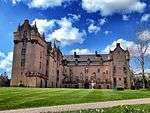 | |||
| Laundry House, Fyvie Castle | 57°26′39″N 2°23′24″W | Category C(S) | 9617 | | |||
| Folla Rule Village Hall | 57°23′13″N 2°26′55″W | Category B | 47442 | | |||
| Maryfield | 57°25′51″N 2°23′38″W | Category C(S) | 9599 | | |||
| Priory Cross, Fyvie | 57°25′47″N 2°23′36″W | Category C(S) | 9612 | | |||
| Manse Of Fyvie, Garden Walls | 57°25′49″N 2°23′16″W | Category C(S) | 9596 | | |||
| Ivy Bridge Over River Ythan W.N.W. Of Fyvie Castle | 57°26′38″N 2°23′50″W | Category B | 9616 | | |||
| East Gate And Lodge Fyvie Castle | 57°26′28″N 2°22′55″W | Category B | 9622 | | |||
| St. George's Rectory Folla Rule | 57°23′14″N 2°26′53″W | Category B | 9587 | | |||
| Masonic Lodge, Lewes, Fyvie | 57°25′45″N 2°23′43″W | Category C(S) | 9598 | | |||
| Old Home Farm, Fyvie Castle | 57°26′37″N 2°23′25″W | Category B | 9618 | | |||
| All Saints Episcopal Church, Woodhead | 57°26′11″N 2°21′05″W | Category B | 9624 | | |||
| Manse (Formerly Woodhead Manse) | 57°26′13″N 2°20′47″W | Category C(S) | 9626 | | |||
| Fyvie Parish Church | 57°25′47″N 2°23′14″W | Category B | 9630 | | |||
| Tifty, Waterwheelhouse | 57°27′24″N 2°22′30″W | Category C(S) | 13720 | | |||
| Manse Of Fyvie, Sundial | 57°25′48″N 2°23′17″W | Category C(S) | 9595 | | |||
| Fyvie Castle South Gates | 57°26′02″N 2°23′53″W | Category C(S) | 9613 | | |||
| Fyvie Castle Boathouse | 57°26′22″N 2°23′25″W | Category B | 9614 | | |||
| Walled Garden, Fyvie Castle | 57°26′35″N 2°23′25″W | Category C(S) | 9619 | | |||
| Fyvie, Main Street, Old School Building | 57°25′53″N 2°23′42″W | Category B | 6749 | | |||
| Fyvie Castle, Disused Privy Between Castle And Ivy Bridge | 57°26′37″N 2°23′48″W | Category C(S) | 6750 | | |||
| North Lodge, Kinbroon, By Rothienorman | 57°24′30″N 2°27′58″W | Category C(S) | 9585 | | |||
| St. George's Episcopal Church, Folla Rule | 57°23′12″N 2°26′51″W | Category B | 9586 | | |||
| Ardlogie House (Former Manse Of Fyvie) | 57°25′49″N 2°23′18″W | Category C(S) | 9594 | | |||
| Oldwood Cottage, Fyvie Castle | 57°26′31″N 2°23′07″W | Category B | 9621 | | |||
| Woodhead Tolbooth (Old Farm House, Woodhead) | 57°26′12″N 2°21′09″W | Category B | 9625 | | |||
| Millbrex Church | 57°28′44″N 2°18′00″W | Category B | 9629 | | |||
| Fyvie Parish Church, Old Churchyard, (Excluding Modern Cemetery) | 57°25′46″N 2°23′14″W | Category C(S) | 9631 | | |||
| Statue, S. Of Walled Garden Fyvie Castle | 57°26′30″N 2°23′29″W | Category B | 9620 | | |||
| North Lodge, Fyvie Castle | 57°26′54″N 2°23′52″W | Category B | 9623 | | |||
| Fetterletter, Twin Circular Structures N.W. Of Farmhouse | 57°26′25″N 2°19′42″W | Category C(S) | 9627 | | |||
| Gight Castle | 57°26′34″N 2°17′27″W | Category B | 9628 | |
Key
The scheme for classifying buildings in Scotland is:
- Category A: "buildings of national or international importance, either architectural or historic; or fine, little-altered examples of some particular period, style or building type."[1]
- Category B: "buildings of regional or more than local importance; or major examples of some particular period, style or building type, which may have been altered."[1]
- Category C: "buildings of local importance; lesser examples of any period, style, or building type, as originally constructed or moderately altered; and simple traditional buildings which group well with other listed buildings."[1]
In March 2016 there were 47,288 listed buildings in Scotland. Of these, 8% were Category A, and 50% were Category B, with the remaining 42% being Category C.[2]
gollark: Why the "structures” folder? Is this typescript?
gollark: Αλε32Βιτ
gollark: Anyway, δοεs the meshnet work?
gollark: WINdows; LOSEnux.
gollark: I don't actually have my sound on. Why would you?
Notes
- Sometimes known as OSGB36, the grid reference (where provided) is based on the British national grid reference system used by the Ordnance Survey.
• "Guide to National Grid". Ordnance Survey. Retrieved 2007-12-12.
• "Get-a-map". Ordnance Survey. Retrieved 2007-12-17. - Historic Environment Scotland assign a unique alphanumeric identifier to each designated site in Scotland, for listed buildings this always begins with "LB", for example "LB12345".
References
- All entries, addresses and coordinates are based on data from Historic Scotland. This data falls under the Open Government Licence
- "What is Listing?". Historic Environment Scotland. Retrieved 29 May 2018.
- Scotland's Historic Environment Audit 2016 (PDF). Historic Environment Scotland and the Built Environment Forum Scotland. pp. 15–16. Retrieved 29 May 2018.
This article is issued from Wikipedia. The text is licensed under Creative Commons - Attribution - Sharealike. Additional terms may apply for the media files.