List of listed buildings in Foveran, Aberdeenshire
List
| Name | Location | Date Listed | Grid Ref. [note 1] | Geo-coordinates | Notes | LB Number [note 2] | Image |
|---|---|---|---|---|---|---|---|
| Foveran House | 57°18′32″N 2°00′57″W | Category B | 9168 | 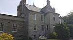 | |||
| Knockhall Castle | 57°19′43″N 2°00′43″W | Category B | 9171 |  | |||
| Newburgh House Main Street | 57°18′55″N 2°00′17″W | Category B | 9174 | | |||
| Udny Family Vault, Old Churchyard, Newburgh | 57°19′17″N 1°59′48″W | Category B | 9175 | | |||
| Foveran House Lodge, Gates And Gatepiers | 57°18′27″N 2°01′33″W | Category C(S) | 9170 | | |||
| Ythan Lodge | 57°19′43″N 2°00′31″W | Category B | 9172 | | |||
| Newburgh Village, Main Street And School Road, Holyrood Chapel | 57°19′02″N 2°00′13″W | Category B | 6797 | 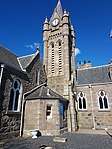 | |||
| Tillery House | 57°17′47″N 2°08′34″W | Category B | 9176 | | |||
| Mill Of Foveran, Farmhouse | 57°18′23″N 2°02′32″W | Category B | 9169 | | |||
| Foveran Parish Church Turing Slab | 57°18′28″N 2°01′36″W | Category A | 9166 | | |||
| Shanghai, 31 Main Street, Newburgh | 57°19′04″N 2°00′14″W | Category B | 9173 | | |||
| Foveran Parish Church | 57°18′28″N 2°01′36″W | Category B | 9165 | 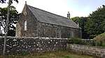 | |||
| Foveran Churchyard | 57°18′28″N 2°01′35″W | Category C(S) | 9167 | |
Key
The scheme for classifying buildings in Scotland is:
- Category A: "buildings of national or international importance, either architectural or historic; or fine, little-altered examples of some particular period, style or building type."[1]
- Category B: "buildings of regional or more than local importance; or major examples of some particular period, style or building type, which may have been altered."[1]
- Category C: "buildings of local importance; lesser examples of any period, style, or building type, as originally constructed or moderately altered; and simple traditional buildings which group well with other listed buildings."[1]
In March 2016 there were 47,288 listed buildings in Scotland. Of these, 8% were Category A, and 50% were Category B, with the remaining 42% being Category C.[2]
gollark: I think this is a reasonable way to do copyright in general; some (much shorter than now!) length where you get exclusivity, which can be extended somewhat if you give the copyright office the source to release at the end of this perioid.
gollark: This isn't really "repair"y, inasmuch as you can't fix it if it breaks unless you happen to be really good at reverse engineering.
gollark: Maybe what you mean is banning DRM-ish things, so you can definitely copy the program and run it elsewhere and such?
gollark: Well, you can't actually run the program if you don't have... the program, DRM or no.
gollark: A lot of things now do the fourth.
Notes
- Sometimes known as OSGB36, the grid reference (where provided) is based on the British national grid reference system used by the Ordnance Survey.
• "Guide to National Grid". Ordnance Survey. Retrieved 2007-12-12.
• "Get-a-map". Ordnance Survey. Retrieved 2007-12-17. - Historic Environment Scotland assign a unique alphanumeric identifier to each designated site in Scotland, for listed buildings this always begins with "LB", for example "LB12345".
References
- All entries, addresses and coordinates are based on data from Historic Scotland. This data falls under the Open Government Licence
- "What is Listing?". Historic Environment Scotland. Retrieved 29 May 2018.
- Scotland's Historic Environment Audit 2016 (PDF). Historic Environment Scotland and the Built Environment Forum Scotland. pp. 15–16. Retrieved 29 May 2018.
This article is issued from Wikipedia. The text is licensed under Creative Commons - Attribution - Sharealike. Additional terms may apply for the media files.