List of listed buildings in Falkland, Fife
List
| Name | Location | Date Listed | Grid Ref. [note 1] | Geo-coordinates | Notes | LB Number [note 2] | Image |
|---|---|---|---|---|---|---|---|
| Graveyard, High Street West Port | 56°15′09″N 3°12′39″W | Category C(S) | 31290 |  | |||
| Dovecot (House), Pleasance | 56°15′12″N 3°12′17″W | Category C(S) | 31295 |  | |||
| Crinan, Back Wynd (Including Garden Walls) | 56°15′10″N 3°12′25″W | Category C(S) | 31298 | | |||
| House (Messrs Thomas & Alexander Pedder), Back Wynd | 56°15′08″N 3°12′23″W | Category C(S) | 31304 | | |||
| Wellbrae, South Street At Corner Of Well Brae (Including Garden Wall To Well Brae) | 56°15′07″N 3°12′23″W | Category B | 31318 | | |||
| House And Shop (Markinch And District Co-Operative Society Ltd) Horsemarket (Including Garden Wall) | 56°15′07″N 3°12′25″W | Category C(S) | 31325 | | |||
| Wester Brunton House (National Trust Formerly Colin Hamilton) Brunton Street, (Including Outbuilding And Garden Walls) | 56°15′09″N 3°12′30″W | Category B | 31329 | | |||
| House (Mr Ross), South Street West | 56°15′09″N 3°12′32″W | Category C(S) | 31333 | | |||
| West Cottage And The Cottage West Port | 56°15′11″N 3°12′44″W | Category C(S) | 31343 | | |||
| Viewhill, West Port | 56°15′11″N 3°12′45″W | Category C(S) | 31344 | | |||
| House Of Falkland East Lodge And Gates West Port | 56°15′13″N 3°12′57″W | Category B | 31350 |  | |||
| 2-6 Royal Terrace | 56°15′01″N 3°12′13″W | Category B | 31358 | | |||
| Falkland Parish Church High Street | 56°15′12″N 3°12′29″W | Category B | 31254 | | |||
| St Andrew House High Street (Including Garden Walls) | 56°15′13″N 3°12′26″W | Category B | 31257 | | |||
| Stag Inn, High Street And Mill Wynd | 56°15′11″N 3°12′31″W | Category B | 31262 | | |||
| House (Mrs Elizabeth Bayne) And Embo, High Street, West Port Opposite Foot Of Lomonds Road | 56°15′11″N 3°12′42″W | Category B | 31271 | | |||
| Old Tollhouse Newton Of Falkland | 56°15′03″N 3°10′54″W | Category C(S) | 8770 | | |||
| 1 Malt Loan (Or Row) Off Jubilee Crescent Newton Of Falkland | 56°15′07″N 3°11′00″W | Category C(S) | 8773 | | |||
| Courtside, High Street West (Including Garage And Garden Walls) | 56°15′10″N 3°12′41″W | Category C(S) | 31292 | | |||
| Oaklea, East Port | 56°15′12″N 3°12′21″W | Category C(S) | 31297 | | |||
| Dunira, Back Wynd | 56°15′11″N 3°12′26″W | Category C(S) | 31305 | | |||
| Lomond Tavern, Horsemarket | 56°15′08″N 3°12′27″W | Category C(S) | 31319 | | |||
| Rosedale, Horsemarket | 56°15′08″N 3°12′26″W | Category C(S) | 31320 | | |||
| Lomond Cottage, West Port | 56°15′10″N 3°12′43″W | Category C(S) | 31347 | | |||
| Rosebank, West Port | 56°15′11″N 3°12′46″W | Category C(S) | 31349 | | |||
| 7, 8 Royal Terrace | 56°14′59″N 3°12′13″W | Category C(S) | 31359 | | |||
| Parish Church Manse Including Garden Wall And Offices, Chapel Yard | 56°14′55″N 3°11′52″W | Category B | 31361 | | |||
| House (Mr Henry Dolly), High Street | 56°15′10″N 3°12′34″W | Category B | 31263 | | |||
| Moncrief House, High Street | 56°15′12″N 3°12′24″W | Category A | 31274 | .jpg) | |||
| Covenanter Hotel (Formerly Commercial Hotel), High Street | 56°15′11″N 3°12′27″W | Category B | 31278 | | |||
| "Betty's" Fashion And Footwear Shop (Mrs Elizabeth Crawford High Street | 56°15′10″N 3°12′31″W | Category B | 31279 | | |||
| Houses (Ross And Drysdale), High Street (Including Garden Walls) | 56°15′10″N 3°12′30″W | Category B | 31282 | | |||
| Newtown Of Falkland Bonthrone Maltings ( Formerly Newton Old Brewery) | 56°15′03″N 3°10′56″W | Category B | 13311 | | |||
| Balmblae Cottage Including Garden Walls Balmblae, Falkland | 56°15′13″N 3°12′31″W | Category B | 8802 | | |||
| Bellfield Cottage, Jubilee Crescent Newton Of Falkland | 56°15′07″N 3°11′02″W | Category C(S) | 8811 | | |||
| House And Shop (H Grant) High Street, Freuchie | 56°14′52″N 3°09′31″W | Category B | 8816 | | |||
| Albert Tavern, High Street, Freuchie | 56°14′53″N 3°09′22″W | Category C(S) | 8817 | | |||
| Freuchie Mill - Miller's House | 56°14′49″N 3°08′50″W | Category C(S) | 8821 | | |||
| Drums Farmhouse | 56°14′06″N 3°10′45″W | Category C(S) | 8823 | | |||
| Pittillock House | 56°13′56″N 3°09′49″W | Category B | 8825 | | |||
| Millfield House, Falkland | 56°15′05″N 3°12′43″W | Category B | 8769 | | |||
| Freuchie, Eden Valley Row, Former Eden Valley Linen Works Including Gate Piers And Boundary Walls | 56°14′59″N 3°09′21″W | Category B | 49305 | | |||
| Newton Of Falkland, Jubilee Crescent And Main Street, Water Pumps And Wells | 56°15′03″N 3°10′59″W | Category C(S) | 45583 | | |||
| Cottages (Drysdale And Davidson), East Port | 56°15′13″N 3°12′19″W | Category B | 31296 | | |||
| House And Stable And Store Building (Miss Smith) Back Wynd | 56°15′10″N 3°12′25″W | Category C(S) | 31306 | | |||
| Seton House, Cross Wynd | 56°15′11″N 3°12′28″W | Category C(S) | 31308 | | |||
| Millbank (Formerly Miller's House Of Bruce's Mill) Mill Wynd | 56°15′12″N 3°12′33″W | Category C(S) | 31338 | | |||
| House (Elizabeth Douglas) Victoria Place | 56°15′04″N 3°12′15″W | Category C(S) | 31354 | | |||
| Gowanbank Well Brae | 56°15′02″N 3°12′16″W | Category C(S) | 31356 | | |||
| High Street, Old Post Office (Miss Middleton) Including Garden Walls | 56°15′12″N 3°12′27″W | Category B | 31258 | | |||
| Falkland Palace Royal Stables And Tennis Court Or Caichpule | 56°15′20″N 3°12′21″W | Category A | 8800 |  | |||
| Balerno And Adjoining Cottage (Archibald Laing). Jubilee Crescent, Newton Of Falkland | 56°15′08″N 3°11′02″W | Category C(S) | 8810 | | |||
| Freuchie Mill | 56°14′48″N 3°08′51″W | Category C(S) | 8820 | | |||
| House Of Falkland, Bridge Over Roaring Or Mill Burn And Adjoining Gatepiers | 56°15′07″N 3°13′26″W | Category B | 8766 | | |||
| Braeside Off Jubilee Crescent Newton Of Falkland | 56°15′06″N 3°11′00″W | Category C(S) | 8772 | | |||
| High Street, West Port, House (Stewart) Including Garden Walls | 56°15′10″N 3°12′38″W | Category C(S) | 31289 | | |||
| Parish Church Hall, New Road | 56°15′14″N 3°12′16″W | Category B | 31293 | | |||
| Hillview (Nelson), Back Wynd (Including Garden Walls) | 56°15′09″N 3°12′24″W | Category C(S) | 31300 | | |||
| Youth Hostel, Back Wynd (Including Garden Walls) | 56°15′09″N 3°12′24″W | Category C(S) | 31301 | | |||
| House (Mrs Lilias Chisholm), Cross Wynd | 56°15′10″N 3°12′28″W | Category B | 31310 | | |||
| The Shien (James Kilbane), Parliament Square, Cross Wynd | 56°15′09″N 3°12′27″W | Category C(S) | 31313 | | |||
| House (Miss Elizabeth Skinner), South Street | 56°15′07″N 3°12′22″W | Category B | 31317 | | |||
| Southbank And Chemist's Shop (Leven) Together With Outbuilding To South Street, Horsemarket | 56°15′08″N 3°12′24″W | Category B | 31326 | | |||
| Brunton House, Brunton Street (Including Garden Walls) | 56°15′09″N 3°12′29″W | Category A | 31328 |  | |||
| Houses (Partly Restored As Cottage Craft Centre And Partly In Ruins) Sharp's Close, Off Brunton Street | 56°15′09″N 3°12′31″W | Category B | 31330 | | |||
| Stable Yard Of Bruce's Mill House, (Now Demolished) | 56°15′12″N 3°12′33″W | Category C(S) | 31337 | | |||
| Mill Wynd Bridge, Over Maspie Burn | 56°15′12″N 3°12′32″W | Category C(S) | 31340 | | |||
| Lilac Bank (2 Houses) West Port | 56°15′10″N 3°12′44″W | Category C(S) | 31348 | | |||
| Key House (Formerly Palace Inn) And Key Cottage, High Street | 56°15′13″N 3°12′26″W | Category B | 31256 | | |||
| The Wee Hoose, High Street, West Port | 56°15′11″N 3°12′39″W | Category C(S) | 31268 | | |||
| Mrs Elizabeth Crawford's Premises (Richard Howden's Shop) High St | 56°15′10″N 3°12′29″W | Category C(S) | 31280 | | |||
| House (Vacant, Mrs Grieve) High Street, North Side, East Of Bridge, Freuchie | 56°14′56″N 3°09′40″W | Category B | 8815 | | |||
| House (G Houston) Lomond Road, Freuchie | 56°14′51″N 3°09′35″W | Category B | 8819 | | |||
| Temple, Green Hill | 56°15′00″N 3°14′33″W | Category C(S) | 8768 | | |||
| Spittal And Son's Property, High Street And South Street West | 56°15′10″N 3°12′32″W | Category B | 31285 | | |||
| House (Mr Alexander Young), High Street (Including Garden Walls) | 56°15′10″N 3°12′35″W | Category B | 31287 | | |||
| House (Mr Mackie, Formerly National Trust For Scotland), Cross Wynd | 56°15′10″N 3°12′28″W | Category B | 31309 | | |||
| Kind Kyttock's Kitchen (Mrs Chisholm) Cross Wynd | 56°15′08″N 3°12′32″W | Category C(S) | 31311 | | |||
| House (Mrs Christina Wylie), Cross Wynd At Corner Of Horse Market | 56°15′08″N 3°12′28″W | Category C(S) | 31314 | | |||
| House (Mr Robert Craig) Horsemarket | 56°15′08″N 3°12′26″W | Category C(S) | 31321 | | |||
| Dundrennan, Horsemarket | 56°15′08″N 3°12′25″W | Category C(S) | 31322 | | |||
| Glenvale House, Mill Wynd | 56°15′12″N 3°12′32″W | Category B | 31335 | | |||
| Millyard House Millyard Off Mill Wynd, Including Garden Walls | 56°15′11″N 3°12′34″W | Category B | 31339 | | |||
| Floraves, West Port | 56°15′11″N 3°12′43″W | Category C(S) | 31342 | | |||
| Hope Cottage, West Port | 56°15′11″N 3°12′47″W | Category C(S) | 31346 | | |||
| House Of Falkland, Fish Pond Bridges | 56°15′13″N 3°13′00″W | Category B | 31351 | | |||
| House Of Falkland, Memorial Chapel | 56°15′08″N 3°13′00″W | Category B | 31352 |  | |||
| 1 Royal Terrace | 56°15′02″N 3°12′15″W | Category B | 31357 | | |||
| Bruce Fountain, High Street | 56°15′11″N 3°12′29″W | Category B | 31255 | | |||
| House (Miss Margaret Shields), High Street, West Port | 56°15′10″N 3°12′40″W | Category C(S) | 31269 | | |||
| Beeways, High Street West | 56°15′11″N 3°12′41″W | Category B | 31270 | | |||
| Bank Of Scotland (Formerly British Linen) And Town Clerk's Office High Street And Back Wynd.(Including Garden Walls) | 56°15′12″N 3°12′25″W | Category B | 31276 | | |||
| Falkland Palace - Castle | 56°15′17″N 3°12′22″W | Category B | 8799 | | |||
| Bellfield Cottage - Outbuilding Jubilee Crescent, Newton Of Falkland | 56°15′06″N 3°11′01″W | Category C(S) | 8812 | | |||
| St Katharine's Church Place, Freuchie | 56°14′51″N 3°09′23″W | Category C(S) | 8818 | | |||
| Freuchie Mill Bridge | 56°14′49″N 3°08′49″W | Category C(S) | 8822 | | |||
| House Of Falkland - Bruce Monument On Black Hill | 56°15′15″N 3°14′49″W | Category B | 8767 | | |||
| Electricity Sub-Station High Street | 56°15′10″N 3°12′32″W | Category B | 31284 | | |||
| House (Empty, Formerly Mrs Jean Clark), Back Wynd | 56°15′08″N 3°12′23″W | Category C(S) | 31303 | | |||
| House (David Bett) Parliament Square, Cross Wynd, Including Buildings Of Courtyard At Rear | 56°15′09″N 3°12′28″W | Category B | 31312 | | |||
| Ivy Cottage And Kirken Cross Wynd | 56°15′07″N 3°12′28″W | Category C(S) | 31315 | | |||
| Three Houses (Mrs Honeyman And National Trust), Brunton Street, At Corner Of Cross Wynd | 56°15′08″N 3°12′29″W | Category B | 31327 | | |||
| House (Mr Walker, Formerly 2 Houses) South Street West Including Garden Walls (Mutual On West Side With Belmont, South Street West) | 56°15′09″N 3°12′31″W | Category C(S) | 31332 | | |||
| Maspie Cottage, Mill Wynd | 56°15′12″N 3°12′32″W | Category C(S) | 31336 | | |||
| Victoria Cottage Victoria Place | 56°15′02″N 3°12′14″W | Category C(S) | 31355 | | |||
| Chapel Yard House, Chapel Yard | 56°14′56″N 3°11′55″W | Category B | 31362 | | |||
| The Saddlers, High Street | 56°15′12″N 3°12′27″W | Category B | 31259 | | |||
| Fountain House, High Street | 56°15′11″N 3°12′30″W | Category B | 31260 | | |||
| Tornaveen, High Street | 56°15′12″N 3°12′21″W | Category B | 31272 | | |||
| Ladieburn Cottage, High Street | 56°15′12″N 3°12′23″W | Category C(S) | 31273 | | |||
| Bruce Arms Inn, High Street (Including Garden Walls) | 56°15′12″N 3°12′24″W | Category B | 31275 | | |||
| Falkland Palace, Walls Enclosing Palace Garden And Stables Including Gates And Tyndall Bruce Statue | 56°15′13″N 3°12′23″W | Category B | 10796 | | |||
| Private Bridge Between Palace And House Of Falkland Over Castle Shotts Drive, With Wall And Gateway On East Side Of Castle Shotts Drive | 56°15′15″N 3°12′33″W | Category B | 8801 | | |||
| In A Nook, High Street, Freuchie | 56°14′55″N 3°09′40″W | Category B | 8814 | | |||
| House Of Falkland - Stables | 56°15′14″N 3°13′04″W | Category B | 8764 | 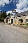 | |||
| Wayside Cottage Jubilee Crescent Newton Of Falkland | 56°15′04″N 3°11′02″W | Category C(S) | 8771 | | |||
| East Lomond Limekiln | 56°14′20″N 3°13′52″W | Category B | 51769 | | |||
| House (John Craig), High Street (Including Garden Walls Mutual With Belmont In South Street West On East Side) | 56°15′09″N 3°12′33″W | Category C(S) | 31286 | | |||
| High Street, Bruce`S Buildings Including Garden Walls | 56°15′10″N 3°12′35″W | Category C(S) | 31288 | | |||
| House (Miss Margaret Shields) High Street West Port (Including Garden Walls) | 56°15′10″N 3°12′40″W | Category B | 31291 | | |||
| Beechgrove, Pleasance | 56°15′13″N 3°12′17″W | Category B | 31294 | | |||
| House (Stebbings), Back Wynd (Including Garden Walls) | 56°15′10″N 3°12′25″W | Category C(S) | 31299 | | |||
| Smith & Anderson's Stable And Store, Back Wynd | 56°15′08″N 3°12′25″W | Category C(S) | 31307 | | |||
| House (Mr William Collins), Horsemarket At Corner Of Back Wynd | 56°15′08″N 3°12′25″W | Category B | 31323 | | |||
| Backdykes, Sharp's Close Off Brunton Street | 56°15′09″N 3°12′30″W | Category C(S) | 31331 | | |||
| Premises (Spittal & Son) South Street West | 56°15′10″N 3°12′32″W | Category B | 31334 | | |||
| Hillerye Cottages, West Port | 56°15′11″N 3°12′46″W | Category C(S) | 31345 | | |||
| Royal Terrace, South Section | 56°14′59″N 3°12′13″W | Category C(S) | 31360 | | |||
| House (National Trust, Empty In 1971), High Street West | 56°15′10″N 3°12′35″W | Category B | 31264 | | |||
| Bellsehill, High Street, West Port | 56°15′10″N 3°12′38″W | Category C(S) | 31267 | | |||
| Falkland Town Hall, High Street | 56°15′11″N 3°12′27″W | Category A | 31277 | | |||
| Newton Of Falkland, Jubilee Crescent, Rose Cottage | 56°15′08″N 3°11′04″W | Category C(S) | 10797 | | |||
| Falkland Palace | 56°15′13″N 3°12′23″W | Category A | 8798 | .JPG) | |||
| Castle Shotts, Including Garden Walls Balmblae, Falkland | 56°15′14″N 3°12′33″W | Category B | 8803 | | |||
| Bridgend, East End, Balmblae, Falkland | 56°15′13″N 3°12′33″W | Category B | 8804 | | |||
| Balreavie, House And Steading | 56°14′43″N 3°11′03″W | Category B | 8813 | | |||
| Drums Doocot | 56°14′04″N 3°10′42″W | Category C(S) | 8824 | | |||
| 2 Malt Loan (Or Row) Off Jubilee Crescent Newton Of Falkland | 56°15′07″N 3°11′00″W | Category C(S) | 8774 | | |||
| Claredale, Rottenrow, Off High Street (Including Outbuildings With Garage On South Street West) | 56°15′10″N 3°12′31″W | Category C(S) | 31283 | | |||
| The Haven, Back Wynd | 56°15′08″N 3°12′24″W | Category B | 31302 | | |||
| Ravenscraig, South Street | 56°15′07″N 3°12′23″W | Category B | 31316 | | |||
| House (Mrs Jane Drysdale), Horsemarket | 56°15′07″N 3°12′25″W | Category C(S) | 31324 | | |||
| The Den, West Port | 56°15′11″N 3°12′43″W | Category C(S) | 31341 | | |||
| House (James Ross) Victoria Place | 56°15′05″N 3°12′15″W | Category C(S) | 31353 | | |||
| Savings Bank And Co-Operative Building, High Street | 56°15′11″N 3°12′30″W | Category C(S) | 31261 | | |||
| Millyard, Off High Street At Rear Of Above | 56°15′11″N 3°12′35″W | Category C(S) | 31265 | | |||
| The Weaver's Cottage (Mrs Jane Goodfellow), High Street, West Port | 56°15′10″N 3°12′37″W | Category B | 31266 | | |||
| Cameron House, High St (Including Garden Walls) | 56°15′10″N 3°12′30″W | Category B | 31281 | | |||
| Balreavie Cottage, Jubilee Crescent Newton Of Falkland | 56°15′07″N 3°11′02″W | Category C(S) | 13695 | | |||
| House Of Falkland (St Ninian's Rc School) Including Terraces And Garden Ornaments | 56°15′11″N 3°13′28″W | Category A | 8763 | 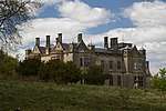 | |||
| House Of Falkland - Gilderland Bridge Over Maspie Burn | 56°15′12″N 3°13′30″W | Category B | 8765 | |
Key
The scheme for classifying buildings in Scotland is:
- Category A: "buildings of national or international importance, either architectural or historic; or fine, little-altered examples of some particular period, style or building type."[1]
- Category B: "buildings of regional or more than local importance; or major examples of some particular period, style or building type, which may have been altered."[1]
- Category C: "buildings of local importance; lesser examples of any period, style, or building type, as originally constructed or moderately altered; and simple traditional buildings which group well with other listed buildings."[1]
In March 2016 there were 47,288 listed buildings in Scotland. Of these, 8% were Category A, and 50% were Category B, with the remaining 42% being Category C.[2]
gollark: User code and random frivolous details.
gollark: The uninstaller RNG is the native and probably problematic Java one.
gollark: xoshiro128++ or something, it's not really used much.
gollark: From what I can tell, though, it's using SHA256 internally.
gollark: Huh, I'm accidentally using an unminified version of the ECC library, that's mildly space-inefficient.
See also
Notes
- Sometimes known as OSGB36, the grid reference (where provided) is based on the British national grid reference system used by the Ordnance Survey.
• "Guide to National Grid". Ordnance Survey. Retrieved 2007-12-12.
• "Get-a-map". Ordnance Survey. Retrieved 2007-12-17. - Historic Environment Scotland assign a unique alphanumeric identifier to each designated site in Scotland, for listed buildings this always begins with "LB", for example "LB12345".
References
- All entries, addresses and coordinates are based on data from Historic Scotland. This data falls under the Open Government Licence
- "What is Listing?". Historic Environment Scotland. Retrieved 29 May 2018.
- Scotland's Historic Environment Audit 2016 (PDF). Historic Environment Scotland and the Built Environment Forum Scotland. pp. 15–16. Retrieved 29 May 2018.
This article is issued from Wikipedia. The text is licensed under Creative Commons - Attribution - Sharealike. Additional terms may apply for the media files.