List of listed buildings in Dunnottar, Aberdeenshire
List
| Name | Location | Date Listed | Grid Ref. [note 1] | Geo-coordinates | Notes | LB Number [note 2] | Image |
|---|---|---|---|---|---|---|---|
| Dunnottar Castle - Stables | 56°56′44″N 2°11′51″W | Category B | 2900 |  | |||
| Dunnottar Castle - Entrance Gateway And Guardrooms | 56°56′46″N 2°11′54″W | Category A | 2919 | | |||
| Dunnottar Castle - Benholms Lodgings | 56°56′46″N 2°11′54″W | Category A | 2920 | | |||
| Stonehaven Radio Station | 56°56′47″N 2°12′46″W | Category C(S) | 49976 | | |||
| Dunnottar Castle - Well | 56°56′46″N 2°11′47″W | Category B | 2905 | 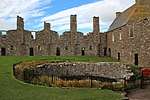 | |||
| Dunnottar Castle - Smithy | 56°56′45″N 2°11′52″W | Category B | 2899 | 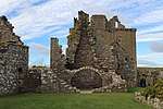 | |||
| Dunnottar Castle - Quadrangle | 56°56′46″N 2°11′46″W | Category B | 2904 | | |||
| Glaslaw Bridge Over Glaslaw Burn | 56°57′01″N 2°13′33″W | Category C(S) | 2907 | | |||
| Bracklaywaird Farmhouse | 56°56′51″N 2°17′15″W | Category C(S) | 2908 | | |||
| By Stonehaven, Green Den | 56°57′31″N 2°12′55″W | Category B | 6640 | | |||
| Dunnottar Castle - Priest's House | 56°56′45″N 2°11′51″W | Category B | 2901 | | |||
| Dunnottar Castle - Grave-Yard Walls | 56°56′45″N 2°11′49″W | Category B | 2902 | | |||
| Dunnottar Castle - East Guardhouse | 56°56′44″N 2°11′46″W | Category B | 2906 | | |||
| Auquhirie Farmhouse | 56°57′24″N 2°17′05″W | Category C(S) | 2909 | | |||
| War Memorial, Black Hill | 56°57′18″N 2°12′10″W | Category C(S) | 2918 | 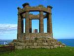 | |||
| Marischal Aisle | 56°57′28″N 2°13′36″W | Category B | 2915 | | |||
| Dunnottar House | 56°57′26″N 2°13′37″W | Category C(S) | 2916 | | |||
| Invercarron Tollhouse | 56°57′39″N 2°12′47″W | Category C(S) | 2917 | | |||
| Dunnottar House (Former) Walled Gardens And Shell House | 56°57′21″N 2°13′21″W | Category B | 6609 | | |||
| Dunnottar Castle - Approach Tunnels | 56°56′45″N 2°11′52″W | Category B | 2897 | | |||
| Dunnottar Castle - Keep | 56°56′45″N 2°11′53″W | Category A | 2898 | | |||
| Dunnottar Castle - Chapel | 56°56′45″N 2°11′47″W | Category B | 2903 | | |||
| Dunnottar Parish Kirk | 56°57′28″N 2°13′38″W | Category B | 2914 | |
Key
The scheme for classifying buildings in Scotland is:
- Category A: "buildings of national or international importance, either architectural or historic; or fine, little-altered examples of some particular period, style or building type."[1]
- Category B: "buildings of regional or more than local importance; or major examples of some particular period, style or building type, which may have been altered."[1]
- Category C: "buildings of local importance; lesser examples of any period, style, or building type, as originally constructed or moderately altered; and simple traditional buildings which group well with other listed buildings."[1]
In March 2016 there were 47,288 listed buildings in Scotland. Of these, 8% were Category A, and 50% were Category B, with the remaining 42% being Category C.[2]
gollark: What?
gollark: Prosperity is going up, extreme poverty down, sort of thing.
gollark: By most metrics, things are generally improving.
gollark: I am not convinced that you could make it all work properly just by having some other political system in the meantime.
gollark: I agree.
Notes
- Sometimes known as OSGB36, the grid reference (where provided) is based on the British national grid reference system used by the Ordnance Survey.
• "Guide to National Grid". Ordnance Survey. Retrieved 2007-12-12.
• "Get-a-map". Ordnance Survey. Retrieved 2007-12-17. - Historic Environment Scotland assign a unique alphanumeric identifier to each designated site in Scotland, for listed buildings this always begins with "LB", for example "LB12345".
References
- All entries, addresses and coordinates are based on data from Historic Scotland. This data falls under the Open Government Licence
- "What is Listing?". Historic Environment Scotland. Retrieved 29 May 2018.
- Scotland's Historic Environment Audit 2016 (PDF). Historic Environment Scotland and the Built Environment Forum Scotland. pp. 15–16. Retrieved 29 May 2018.
This article is issued from Wikipedia. The text is licensed under Creative Commons - Attribution - Sharealike. Additional terms may apply for the media files.