List of listed buildings in Dunnichen, Angus
List
| Name | Location | Date Listed | Grid Ref. [note 1] | Geo-coordinates | Notes | LB Number [note 2] | Image |
|---|---|---|---|---|---|---|---|
| Hall Of Letham, The Square | 56°37′45″N 2°46′10″W | Category C(S) | 4605 |  | |||
| Old Church, Off The Square, Letham | 56°37′42″N 2°46′05″W | Category C(S) | 4606 | | |||
| Letham, 21 The Den, Blunt Neuk | 56°37′38″N 2°45′45″W | Category C(S) | 6469 | | |||
| Craichie Old Cornmill | 56°36′37″N 2°48′35″W | Category C(S) | 4601 | 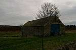 | |||
| Letham Den Cottages | 56°37′40″N 2°45′41″W | Category C(S) | 4607 | | |||
| Parish Kirk Manse | 56°37′39″N 2°48′01″W | Category B | 4619 | | |||
| Dunnichen Parish Kirk | 56°37′42″N 2°48′04″W | Category B | 4618 | 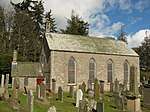 | |||
| Bractullo Bridge Over Bractullomill Burn | 56°36′20″N 2°47′01″W | Category C(S) | 4604 | | |||
| Letham Den Bridge Over Vinny Water | 56°37′37″N 2°45′44″W | Category B | 4608 | | |||
| 20 Blairs Road | 56°37′36″N 2°46′29″W | Category C(S) | 4610 | | |||
| 7 Braehead Road | 56°37′27″N 2°46′03″W | Category C(S) | 4609 | | |||
| Craichie Mill Farmhouse | 56°36′36″N 2°48′37″W | Category C(S) | 4620 | |
Key
The scheme for classifying buildings in Scotland is:
- Category A: "buildings of national or international importance, either architectural or historic; or fine, little-altered examples of some particular period, style or building type."[1]
- Category B: "buildings of regional or more than local importance; or major examples of some particular period, style or building type, which may have been altered."[1]
- Category C: "buildings of local importance; lesser examples of any period, style, or building type, as originally constructed or moderately altered; and simple traditional buildings which group well with other listed buildings."[1]
In March 2016 there were 47,288 listed buildings in Scotland. Of these, 8% were Category A, and 50% were Category B, with the remaining 42% being Category C.[2]
gollark: Oh, yes, that. I don't know how it works.
gollark: You can't upload more.
gollark: All you can do is pick music from my library, which you don't like.
gollark: Why would you want to control OIR, anyway?
gollark: I fixed that.
See also
Notes
- Sometimes known as OSGB36, the grid reference (where provided) is based on the British national grid reference system used by the Ordnance Survey.
• "Guide to National Grid". Ordnance Survey. Retrieved 2007-12-12.
• "Get-a-map". Ordnance Survey. Retrieved 2007-12-17. - Historic Environment Scotland assign a unique alphanumeric identifier to each designated site in Scotland, for listed buildings this always begins with "LB", for example "LB12345".
References
- All entries, addresses and coordinates are based on data from Historic Scotland. This data falls under the Open Government Licence
- "What is Listing?". Historic Environment Scotland. Retrieved 29 May 2018.
- Scotland's Historic Environment Audit 2016 (PDF). Historic Environment Scotland and the Built Environment Forum Scotland. pp. 15–16. Retrieved 29 May 2018.
This article is issued from Wikipedia. The text is licensed under Creative Commons - Attribution - Sharealike. Additional terms may apply for the media files.