List of listed buildings in Dunlop, East Ayrshire
List
| Name | Location | Date Listed | Grid Ref. [note 1] | Geo-coordinates | Notes | LB Number [note 2] | Image |
|---|---|---|---|---|---|---|---|
| 75 Main Street, Manse Cottage | 55°42′42″N 4°32′23″W | Category C(S) | 5198 |  | |||
| 64 And 66 Main Street | 55°42′43″N 4°32′19″W | Category C(S) | 5199 | | |||
| 86, 88, And 90 Main Street With Boundary Walls, Gatepiers And Railings | 55°42′43″N 4°32′23″W | Category C(S) | 5200 | | |||
| 2 And 4 Lugton Road | 55°42′46″N 4°31′59″W | Category C(S) | 5202 | | |||
| Mains Of Aiket With Flanking Byres, Ancillary Buildings, Treetops Cottage, Boundary Walls, Gates And Gatepiers | 55°42′13″N 4°32′22″W | Category B | 50088 | | |||
| 81 Main Street, Oran | 55°42′43″N 4°32′20″W | Category C(S) | 50097 | | |||
| 87 Main Street, Newfield | 55°42′43″N 4°32′22″W | Category C(S) | 50100 | | |||
| 91 Main Street | 55°42′43″N 4°32′23″W | Category C(S) | 50102 | | |||
| 95 Main Street | 55°42′42″N 4°32′24″W | Category C(S) | 50104 | | |||
| Muirshiel With Ancillary Buildings | 55°43′39″N 4°29′45″W | Category C(S) | 5180 | | |||
| 2 Stewarton Road And 19 Main Street, The Village Inn | 55°42′43″N 4°32′05″W | Category C(S) | 5197 | | |||
| 92 Main Street, Kirkgate, With Boundary Wall | 55°42′43″N 4°32′24″W | Category C(S) | 5201 | | |||
| Aiket Castle With Adjoining Cottage, Barmkin Wall, Aiket Mill, And Former Mill Lades | 55°42′19″N 4°34′02″W | Category C(S) | 50079 | 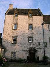 | |||
| Leahead With Byres, Boundary Walls, Gates And Gatepiers | 55°42′09″N 4°34′32″W | Category C(S) | 50081 | | |||
| 67 Main Street | 55°42′43″N 4°32′14″W | Category C(S) | 50083 | | |||
| 30 Main Street With Boundary Wall, Gates And Railings | 55°42′45″N 4°32′06″W | Category C(S) | 50087 | | |||
| Low Borland With Byres, Former Threshing Barn And Other Ancillary Buildings | 55°42′15″N 4°33′35″W | Category B | 5185 | | |||
| Main Street, Clandeboye School | 55°42′42″N 4°32′26″W | Category A | 5192 | | |||
| Dunlop House, West Lodge With Boundary Walls, Gatepiers And Railings | 55°42′48″N 4°30′53″W | Category C(S) | 50080 | | |||
| 14 Lugton Road With Gatepiers And Boundary Wall | 55°42′47″N 4°31′59″W | Category C(S) | 50082 | | |||
| 83 Main Street | 55°42′43″N 4°32′21″W | Category C(S) | 50098 | | |||
| 78 And 80 Main Street | 55°42′43″N 4°32′20″W | Category C(S) | 50108 | | |||
| 84 Main Street | 55°42′43″N 4°32′21″W | Category C(S) | 50110 | | |||
| Braehead With Former Threshing Barn, Boundary Wall, Gates And Gatepiers | 55°42′19″N 4°34′18″W | Category C(S) | 5189 | | |||
| 69 Main Street | 55°42′43″N 4°32′15″W | Category C(S) | 50084 | | |||
| 71 Main Street | 55°42′43″N 4°32′16″W | Category C(S) | 50085 | | |||
| 17 Newmill Road, Struthers, With Ancillary Buildings | 55°42′48″N 4°31′47″W | Category C(S) | 50089 | | |||
| Pollick | 55°45′40″N 4°30′06″W | Category C(S) | 50091 | | |||
| 79 Main Street | 55°42′43″N 4°32′20″W | Category C(S) | 50096 | | |||
| 89 Main Street | 55°42′43″N 4°32′22″W | Category C(S) | 50101 | | |||
| East Halket With Ancillary Buildings, Boundary Wall, Gates And Gatepiers | 55°44′24″N 4°30′23″W | Category C(S) | 5179 | | |||
| Over Borland With Byres, Walled Garden, Boundary Wall And Gatepiers | 55°42′36″N 4°32′57″W | Category C(S) | 5186 | | |||
| Main Street, Parish Church Graveyard, Hans Hamilton's Tomb | 55°42′42″N 4°32′26″W | Category A | 5191 | 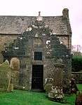 | |||
| 73 Main Street, The Old Manse, With Former Stable And Coach House, Boundary Walls, Gates And Gatepiers | 55°42′42″N 4°32′17″W | Category C(S) | 5193 | | |||
| 62 Main Street, Kirkland With Former Coach House And Stables, Boundary Wall, Gates And Gatepiers | 55°42′45″N 4°32′17″W | Category A | 5194 | | |||
| North Borland With Gates And Gatepiers And North Borland Cottage | 55°42′47″N 4°32′55″W | Category C(S) | 50090 | | |||
| Stewarton Road, Viaduct | 55°42′35″N 4°32′00″W | Category C(S) | 50092 | | |||
| Stewarton Road, Windyridge | 55°42′29″N 4°31′57″W | Category C(S) | 50093 | | |||
| Craignaught With Flanking Byres And Former Threshing Barn | 55°43′51″N 4°28′45″W | Category B | 5181 | | |||
| Dunlop House With Bridge | 55°42′42″N 4°30′17″W | Category A | 5187 | | |||
| Bourock With Ancillary Buildings | 55°43′44″N 4°32′08″W | Category C(S) | 5204 | | |||
| 85 Main Street | 55°42′43″N 4°32′21″W | Category C(S) | 50099 | | |||
| 82 Main Street | 55°42′43″N 4°32′21″W | Category C(S) | 50109 | | |||
| The Hill With Ancillary Buildings, Boundary Walls, Gates And Gatepiers | 55°42′25″N 4°31′40″W | Category A | 5184 | | |||
| Loanhead Including Byres, Boundary Walls, Gates And Gatepiers | 55°42′25″N 4°34′10″W | Category B | 5188 | | |||
| Main Street, Dunlop Parish Church (Church Of Scotland) With Boundary Walls, Gatepiers, And Graveyard | 55°42′43″N 4°32′27″W | Category B | 5190 | | |||
| Main Street, Church Hall (Former Free Church) With Boundary Wall, Gates And Railings | 55°42′45″N 4°32′12″W | Category C(S) | 5195 | | |||
| Straightbow Bridge | 55°42′42″N 4°32′29″W | Category C(S) | 50094 | | |||
| 93 Main Street, Edenville | 55°42′43″N 4°32′23″W | Category C(S) | 50103 | | |||
| 68 And 70 Main Street, The Auld Hoose | 55°42′43″N 4°32′18″W | Category C(S) | 50105 | | |||
| 72 And 74 Main Street | 55°42′43″N 4°32′19″W | Category C(S) | 50106 | | |||
| 76 Main Street, Cobble Cottage | 55°42′43″N 4°32′20″W | Category C(S) | 50107 | | |||
| 33 Main Street, The Old Schoolhouse, With Ancillary Buildings And Boundary Walls | 55°42′43″N 4°32′08″W | Category C(S) | 5196 | | |||
| 77 Main Street | 55°42′43″N 4°32′19″W | Category C(S) | 50095 | |
Key
The scheme for classifying buildings in Scotland is:
- Category A: "buildings of national or international importance, either architectural or historic; or fine, little-altered examples of some particular period, style or building type."[1]
- Category B: "buildings of regional or more than local importance; or major examples of some particular period, style or building type, which may have been altered."[1]
- Category C: "buildings of local importance; lesser examples of any period, style, or building type, as originally constructed or moderately altered; and simple traditional buildings which group well with other listed buildings."[1]
In March 2016 there were 47,288 listed buildings in Scotland. Of these, 8% were Category A, and 50% were Category B, with the remaining 42% being Category C.[2]
gollark: Unless you already did so or were planning to do so, in which case do so.
gollark: <@!309787486278909952> Multiply matrices already.
gollark: What community guidelines forbid 4D geometry?
gollark: &colour 0bee00
gollark: &colour abcdef
Notes
- Sometimes known as OSGB36, the grid reference (where provided) is based on the British national grid reference system used by the Ordnance Survey.
• "Guide to National Grid". Ordnance Survey. Retrieved 2007-12-12.
• "Get-a-map". Ordnance Survey. Retrieved 2007-12-17. - Historic Environment Scotland assign a unique alphanumeric identifier to each designated site in Scotland, for listed buildings this always begins with "LB", for example "LB12345".
References
- All entries, addresses and coordinates are based on data from Historic Scotland. This data falls under the Open Government Licence
- "What is Listing?". Historic Environment Scotland. Retrieved 29 May 2018.
- Scotland's Historic Environment Audit 2016 (PDF). Historic Environment Scotland and the Built Environment Forum Scotland. pp. 15–16. Retrieved 29 May 2018.
This article is issued from Wikipedia. The text is licensed under Creative Commons - Attribution - Sharealike. Additional terms may apply for the media files.