List of listed buildings in Dunbar, East Lothian
List
| Name | Location | Date Listed | Grid Ref. [note 1] | Geo-coordinates | Notes | LB Number [note 2] | Image |
|---|---|---|---|---|---|---|---|
| Queen's Road, 6-11 (Inclusive Nos) Bowmont Terrace | 55°59′54″N 2°30′30″W | Category B | 24847 |  | |||
| Roxburghe Terrace, Kirkhill House | 55°59′51″N 2°30′14″W | Category B | 24849 | | |||
| Station Road, Dunbar Railway Station And Station Lodge | 55°59′54″N 2°30′47″W | Category B | 24857 | | |||
| 2-9 (Inclusive Nos) Victoria Street | 56°00′14″N 2°30′59″W | Category B | 24860 | | |||
| 1 Delisle Street | 56°00′08″N 2°31′04″W | Category C(S) | 24758 | | |||
| East Links Road, St Ronans With Garden Walls And Gateway | 56°00′01″N 2°30′41″W | Category B | 24765 | | |||
| 23 High Street, Bamburgh Castle (Through Close Of 21-25 High Street) | 56°00′03″N 2°30′51″W | Category B | 24774 | | |||
| 27 And 29 High Street (Formerly Known As 1 And 2 Templelands) | 56°00′03″N 2°30′52″W | Category B | 24775 | | |||
| 73 And 75 High Street (Eagle Inn) | 56°00′07″N 2°30′56″W | Category B | 24787 | | |||
| High Street, Courtyard Through 71-75 High Street | 56°00′07″N 2°30′55″W | Category A | 24788 | | |||
| 97 And 99 High Street | 56°00′09″N 2°30′57″W | Category B | 24792 | | |||
| 165 High Street And 1 Victoria Street, Castle Hotel | 56°00′13″N 2°31′00″W | Category C(S) | 24796 | | |||
| 40 High Street | 56°00′05″N 2°30′56″W | Category B | 24803 | | |||
| High Street (Close Through 90 High Street) | 56°00′08″N 2°30′59″W | Category B | 24816 | | |||
| High Street Close Of 106 | 56°00′09″N 2°31′01″W | Category B | 24820 | | |||
| 110 And 112 High Street | 56°00′10″N 2°31′03″W | Category B | 24822 | | |||
| 136 And 138 High Street | 56°00′11″N 2°31′02″W | Category C(S) | 24826 | | |||
| High Street, Lauderdale House | 56°00′13″N 2°31′03″W | Category A | 24829 | 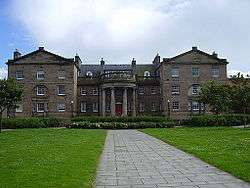 | |||
| 21 And 23 Lamer Street | 56°00′16″N 2°30′52″W | Category C(S) | 24833 | | |||
| 25 Lamer Street, Jersey Arms | 56°00′16″N 2°30′52″W | Category C(S) | 24834 | | |||
| 10 And 12 Lamer Street | 56°00′11″N 2°30′50″W | Category C(S) | 24836 | | |||
| Belhaven Belhaven Hill Boys School, Stables, Lodge Walled Garden And Gate Piers | 56°00′06″N 2°32′09″W | Category B | 24733 | | |||
| Belhaven, 5 Duke Street | 55°59′56″N 2°32′23″W | Category B | 24736 | | |||
| Belhaven, 7 And 9 Duke Street, Outbuilding, Walls And Piers | 55°59′56″N 2°32′25″W | Category B | 24737 | | |||
| Belhaven, 22 Duke Street, Charnwood | 55°59′54″N 2°32′29″W | Category B | 24739 | | |||
| Belhaven, Edinburgh Road, Seafield Crescent | 55°59′53″N 2°32′28″W | Category B | 24740 | | |||
| Barns Ness Lighthouse With Keepers' Cottages And Retaining Walls | 55°59′13″N 2°26′44″W | Category B | 1465 | | |||
| Broxmouth Park, Observatory (Also Known As Sloe Bigging Lookout Tower) | 55°59′35″N 2°28′56″W | Category C(S) | 1472 | | |||
| Oxwellmains Windmill | 55°58′44″N 2°28′45″W | Category B | 1475 | | |||
| 1-8 (Inclusive Nos) Eweford Farm Cottages | 55°59′21″N 2°32′15″W | Category C(S) | 1506 | | |||
| Hedderwick Hill Stables With Dairy Pavilion | 55°59′43″N 2°34′49″W | Category B | 1510 | | |||
| 3-9 (Odd Nos) Victoria Place | 56°00′18″N 2°30′53″W | Category B | 51777 | | |||
| 19A,19B, 19C Victoria Street, 10 And 12 Writer's Court Including Boundary Walls | 56°00′16″N 2°30′53″W | Category B | 51779 | | |||
| Roxburghe Terrace, Newhouse Farm Steading And Horsemill | 55°59′51″N 2°30′21″W | Category B | 24850 | | |||
| Victoria Street, Volunteer Arms | 56°00′16″N 2°30′53″W | Category C(S) | 24861 | | |||
| 12-30 (Even Nos) Victoria Street | 56°00′17″N 2°30′53″W | Category B | 24862 | | |||
| 9 West Port | 56°00′08″N 2°31′02″W | Category B | 24865 | | |||
| 13 West Port | 56°00′08″N 2°31′03″W | Category B | 24866 | | |||
| 15 Church Street, Beach House | 56°00′08″N 2°30′51″W | Category B | 24753 | | |||
| Church Street, Old Assembly Rooms | 56°00′07″N 2°30′50″W | Category B | 24754 | | |||
| Delisle Street, Friar's Croft Dovecot | 56°00′05″N 2°31′05″W | Category A | 24764 | 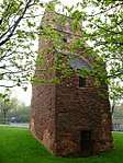 | |||
| East Links Road, St Ninians, Inchgarth And Retaining Wall | 56°00′00″N 2°30′40″W | Category B | 24766 | | |||
| 7 High Street, Port Lodge | 56°00′02″N 2°30′48″W | Category B | 24770 | | |||
| 31-35 (Odd Nos) High Street | 56°00′04″N 2°30′53″W | Category B | 24776 | | |||
| 55 And 59 High Street | 56°00′05″N 2°30′54″W | Category B | 24782 | | |||
| 61 And 63 High Street | 56°00′06″N 2°30′55″W | Category B | 24783 | | |||
| 105 High Street | 56°00′10″N 2°30′58″W | Category C(S) | 24793 | | |||
| 56-60 (Even Nos) High Street | 56°00′06″N 2°30′58″W | Category A | 24806 | | |||
| 58 High Street Monkswalk And G W Day's House (Through Close Of No 56-60) High Street | 56°00′06″N 2°30′59″W | Category C(S) | 24807 | | |||
| 62-66 (Even Nos) High Street | 56°00′06″N 2°30′58″W | Category B | 24808 | | |||
| High Street Close Of 102 | 56°00′09″N 2°31′00″W | Category B | 24818 | | |||
| 104 High Street | 56°00′09″N 2°31′00″W | Category B | 24819 | | |||
| 114 And 116 High Street | 56°00′10″N 2°31′00″W | Category B | 24824 | | |||
| Lawson Place, Baker's Croft (Formerly St Anne's Rectory) | 56°00′11″N 2°31′07″W | Category B | 24837 | | |||
| Old Harbour, Spott's Granary | 56°00′18″N 2°30′46″W | Category B | 24840 | | |||
| Belhaven, 11 High Street | 55°59′56″N 2°32′16″W | Category C(S) | 24745 | | |||
| Belhaven, 7 North Street | 55°59′56″N 2°32′31″W | Category B | 24748 | | |||
| Belton Lodge With Gatepiers And Quadrant Walls | 55°58′56″N 2°34′02″W | Category B | 1468 | | |||
| Broxburn, Thistle Inn | 55°59′14″N 2°29′32″W | Category B | 1469 | | |||
| Broxmouth Park (Broxmouth House) With Boundary Walls, Gatepiers And Bridge | 55°59′25″N 2°29′19″W | Category B | 1470 | | |||
| East Barns Cartshed And Granary, Power House And Stalk | 55°58′41″N 2°27′17″W | Category B | 1504 | | |||
| Hallhill Farmhouse | 55°59′33″N 2°31′23″W | Category B | 1508 | | |||
| Hedderwick Farmhouse | 55°59′14″N 2°35′21″W | Category B | 1509 | | |||
| North Belton Farmhouse | 55°59′11″N 2°34′49″W | Category C(S) | 1518 | | |||
| 101, 103 High Street | 56°00′09″N 2°30′58″W | Category C(S) | 51160 | | |||
| 1-4 (Consecutive Nos) Buncles Court, 30-38 (Even Nos) Lamer Street | 56°00′15″N 2°30′52″W | Category B | 51775 | | |||
| 1 And 3 Shore Street, Also Known As Old Harbour | 56°00′14″N 2°30′49″W | Category B | 24851 | | |||
| 21 West Port | 56°00′08″N 2°31′03″W | Category B | 24867 | | |||
| 3 Delisle Street, Croft House | 56°00′08″N 2°31′06″W | Category B | 24759 | | |||
| Golf House Road, Beachcote | 55°59′54″N 2°30′21″W | Category C(S) | 24769 | | |||
| 137 And 139 High Street | 56°00′12″N 2°30′58″W | Category B | 24795 | | |||
| 50-54 (Even Numbers) High Street | 56°00′06″N 2°30′58″W | Category C(S) | 24805 | | |||
| 76 High Street | 56°00′07″N 2°30′58″W | Category B | 24812 | | |||
| 80-84 (Even Nos) High Street | 56°00′07″N 2°30′59″W | Category B | 24813 | | |||
| 86 And 88 High Street | 56°00′08″N 2°30′59″W | Category C(S) | 24814 | | |||
| 90 And 92 High Street | 56°00′08″N 2°30′59″W | Category B | 24815 | | |||
| 126 And 128 High Street | 56°00′10″N 2°31′01″W | Category B | 24825 | | |||
| Queen's Road, 3-5 (Inclusive Nos) Bowmont Terrace | 55°59′53″N 2°30′27″W | Category B | 24846 | | |||
| Bayswell Park Drinking Fountain | 56°00′17″N 2°31′28″W | Category C(S) | 24728 | | |||
| Belhaven, Edinburgh Road Summerfield And Lodge | 55°59′58″N 2°32′07″W | Category C(S) | 24742 | | |||
| Belhaven, 2 North Street | 55°59′56″N 2°32′30″W | Category C(S) | 24750 | | |||
| Broxmouth Stable Court And Gatepiers | 55°59′28″N 2°29′15″W | Category B | 1473 | | |||
| West Barns, Bielside South Lodge With Gatepiers And Quadrants | 55°59′42″N 2°33′21″W | Category C(S) | 1479 | | |||
| West Barns Inn | 55°59′42″N 2°33′18″W | Category B | 1481 | | |||
| Hallhill Cottages | 55°59′41″N 2°31′23″W | Category C(S) | 1507 | | |||
| Hedderwick Hill Walled Garden | 55°59′34″N 2°34′56″W | Category C(S) | 1511 | | |||
| Lochend Gatepiers And Boundary Walls | 55°59′40″N 2°31′22″W | Category C(S) | 1513 | | |||
| Ninewar With Walled Garden, Gardener's Cottage And Gatepiers | 55°59′14″N 2°36′14″W | Category B | 1516 | | |||
| 7 Shore Street, Also Known As Old Harbour | 56°00′13″N 2°30′48″W | Category B | 24853 | | |||
| 3 Silver Street | 56°00′07″N 2°30′55″W | Category B | 24856 | | |||
| Belhaven Road, Eden Hotel | 56°00′04″N 2°31′19″W | Category B | 24751 | | |||
| 2 Colvin Street, Foresters Arms | 56°00′09″N 2°30′52″W | Category C(S) | 24755 | | |||
| Off Countess Road, The Retreat With Stables And Walled Garden | 55°59′49″N 2°31′04″W | Category B | 24757 | | |||
| East Links Road, St Julians (Formerly 1-3 Clyde Villas) | 55°59′59″N 2°30′37″W | Category C(S) | 24768 | | |||
| 41 High Street | 56°00′04″N 2°30′54″W | Category B | 24777 | | |||
| 41C High Street (Through Close) | 56°00′05″N 2°30′53″W | Category B | 24778 | | |||
| 77 High Street | 56°00′07″N 2°30′56″W | Category B | 24789 | | |||
| 133 And 135 High Street | 56°00′11″N 2°30′59″W | Category C(S) | 24794 | | |||
| High Street, Abbey Church, Retaining Walls And Lamp Standards | 56°00′01″N 2°30′52″W | Category B | 24797 | | |||
| Knockenhair Road, Knockenhair House, Old Windmill, Lodge And Gatepiers | 56°00′08″N 2°31′51″W | Category B | 24830 | | |||
| Old Harbour Fishermen's Monument | 56°00′15″N 2°30′46″W | Category B | 24841 | | |||
| Queen's Road Parish Church And Graveyard, Church Of Scotland | 55°59′57″N 2°30′42″W | Category A | 24842 | 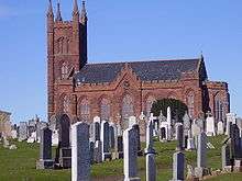 | |||
| Belhaven, 1 And 3 Duke Street | 55°59′56″N 2°32′22″W | Category B | 24735 | | |||
| Belhaven, 4 Duke Street | 55°59′55″N 2°32′23″W | Category C(S) | 24738 | | |||
| Belhaven, 7 High Street | 55°59′56″N 2°32′17″W | Category C(S) | 24743 | | |||
| Broxmouth Park, Walled Garden With Tool Sheds And Kitchen Garden And Gatepiers | 55°59′20″N 2°29′05″W | Category C(S) | 1471 | | |||
| Broxmouth South Lodge With Gatepiers And Quadrants | 55°59′08″N 2°29′10″W | Category A | 1474 | | |||
| Meikle Pinkerton Dovecot | 55°58′23″N 2°28′40″W | Category B | 1515 | | |||
| 1 And 2, 3 And 4 5 And 6 North Belton Cottages | 55°59′10″N 2°34′49″W | Category C(S) | 1517 | | |||
| 15A, 15B, 15C, 15D Victoria Street, 8 Writer's Court Including Boundary Walls | 56°00′15″N 2°30′55″W | Category B | 51778 | | |||
| Victoria Harbour, Yellowcraig | 56°00′18″N 2°30′56″W | Category B | 24859 | | |||
| Victoria Street Well-Head | 56°00′16″N 2°30′54″W | Category C(S) | 24863 | | |||
| 5 Delisle Street | 56°00′07″N 2°31′07″W | Category B | 24761 | | |||
| Delisle Street, Castellau | 56°00′07″N 2°31′10″W | Category B | 24762 | | |||
| 71 High Street | 56°00′07″N 2°30′56″W | Category C(S) | 24786 | | |||
| High Street, 3 Abbeylands | 56°00′02″N 2°30′54″W | Category C(S) | 24799 | | |||
| High Street, Abbeylands, The Priory | 56°00′02″N 2°30′59″W | Category B | 24801 | | |||
| 98 And 100 High Street And 1 West Port | 56°00′09″N 2°31′00″W | Category B | 24817 | | |||
| High Street Close Of 110 | 56°00′09″N 2°31′01″W | Category B | 24823 | | |||
| High Street, St Anne's Church (Episcopal) | 56°00′12″N 2°31′04″W | Category B | 24828 | | |||
| Lamer Street Warehouse (Dreadnought) | 56°00′14″N 2°30′51″W | Category B | 24835 | | |||
| Belhaven, Belhaven Brewery (Maltings, Kilns, Vaults, Brewhouse, Boilerhouse, Chimney, Office, Former Stable And Mill) | 55°59′50″N 2°32′16″W | Category A | 24730 | | |||
| Belhaven, 8 High Street, Masons Arms | 55°59′56″N 2°32′17″W | Category C(S) | 24744 | | |||
| Belhaven, North Street, Garden Pavilion Of 1 North Street And Conservatory | 55°59′56″N 2°32′29″W | Category B | 24747 | | |||
| Belhaven, 9-12 (Inclusive Nos) North Street | 55°59′57″N 2°32′32″W | Category B | 24749 | | |||
| Belton Dovecot | 55°58′59″N 2°34′10″W | Category B | 1466 | | |||
| Belton, Gardiner's House | 55°58′51″N 2°34′09″W | Category B | 1467 | | |||
| Tynefield With Retaining Walls | 55°59′31″N 2°35′46″W | Category B | 1476 | | |||
| West Barns House With Gatepiers, Railings, And Retaining Walls | 55°59′40″N 2°33′24″W | Category B | 1480 | | |||
| Countess Road, Viewfield | 55°59′59″N 2°30′54″W | Category B | 24756 | | |||
| 4 Delisle Street | 56°00′07″N 2°31′07″W | Category B | 24760 | | |||
| 9 High Street, Barnlea | 56°00′02″N 2°30′49″W | Category B | 24771 | | |||
| 15 High Street And Stable | 56°00′02″N 2°30′50″W | Category B | 24772 | | |||
| 21 And 25 High Street | 56°00′03″N 2°30′51″W | Category C(S) | 24773 | | |||
| 47 And 49 High Street | 56°00′05″N 2°30′54″W | Category B | 24779 | | |||
| 67 High Street | 56°00′06″N 2°30′54″W | Category B | 24784 | | |||
| 69 High Street St George Hotel | 56°00′07″N 2°30′55″W | Category B | 24785 | | |||
| High Street, Town House (Tolbooth) | 56°00′08″N 2°30′56″W | Category A | 24790 | 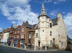 | |||
| High Street, 1 And 2 Abbeylands | 56°00′02″N 2°30′54″W | Category B | 24798 | | |||
| 68 And 70 High Street | 56°00′07″N 2°30′58″W | Category C(S) | 24809 | | |||
| Building At Rear 72 High Street Through Close To North | 56°00′07″N 2°30′59″W | Category B | 24811 | | |||
| 146 And 148 High Street | 56°00′12″N 2°31′02″W | Category C(S) | 24827 | | |||
| Queen's Road, Parish War Memorial | 55°59′58″N 2°30′43″W | Category B | 24843 | | |||
| Queen's Road, 1 And 2 Bowmont Terrace | 55°59′53″N 2°30′25″W | Category B | 24845 | | |||
| Belhaven, Beveridge Row Sycamore Lodge | 55°59′50″N 2°32′26″W | Category B | 24729 | | |||
| Belhaven, Brewery Lane, Monkscroft, Garden Pavilion/Bothy | 55°59′52″N 2°32′16″W | Category B | 24731 | | |||
| West Barns, Ardshiel | 55°59′42″N 2°33′19″W | Category C(S) | 1477 | | |||
| West Barns, Bielside House With Former Windmill | 55°59′47″N 2°33′18″W | Category B | 1478 | | |||
| Catcraig Limekilns | 55°59′15″N 2°27′30″W | Category B | 1502 | | |||
| Dunbar Links, The Vaults | 55°59′45″N 2°28′46″W | Category B | 1503 | | |||
| East Barns, Grieve's House With Garden Walls | 55°58′43″N 2°27′17″W | Category B | 1505 | | |||
| Lochend Gardener's House And Walled Garden | 55°59′43″N 2°31′02″W | Category C(S) | 1512 | | |||
| Station Road, Lodge (Former Station Lodge) | 55°59′55″N 2°30′48″W | Category B | 24858 | | |||
| 28B And 28C Castle Street | 56°00′13″N 2°30′57″W | Category C(S) | 24752 | | |||
| East Links Road, Lismore And Oriel Cottage | 56°00′00″N 2°30′39″W | Category C(S) | 24767 | | |||
| 51 And 53 High Street | 56°00′05″N 2°30′54″W | Category B | 24780 | | |||
| High Street, Abbeylands, Bield | 56°00′01″N 2°30′57″W | Category B | 24800 | | |||
| 72 And 74 High Street | 56°00′07″N 2°30′58″W | Category B | 24810 | | |||
| Lamer Island, The Battery | 56°00′22″N 2°30′47″W | Category B | 24831 | | |||
| 15-19 Lamer Street (Odd Nos) Warehouse/Workshop | 56°00′15″N 2°30′51″W | Category B | 24832 | | |||
| Marine Road, St Rule's, St Relugas | 56°00′21″N 2°31′34″W | Category B | 24838 | | |||
| Old Harbour, Quays And Piers (Cromwell Harbour) | 56°00′18″N 2°30′45″W | Category B | 24839 | | |||
| Queen's Road, Hotel Bellevue | 55°59′55″N 2°30′36″W | Category B | 24844 | | |||
| Belhaven, Belhaven Road Belhaven Church, Church Of Scotland | 56°00′02″N 2°31′58″W | Category B | 24732 | | |||
| Belhaven, 1 North Street | 55°59′55″N 2°32′29″W | Category B | 24746 | | |||
| West Barns, Sherriff Works With Stalk | 55°59′38″N 2°33′18″W | Category B | 1483 | | |||
| The Brunt Steading | 55°57′20″N 2°30′18″W | Category B | 1501 | | |||
| 1-6 (Consecutive Nos) Harbour Court, Castle Gate | 56°00′18″N 2°30′55″W | Category B | 51776 | | |||
| Queen's Road, 12 Bowmont Terrace | 55°59′55″N 2°30′31″W | Category B | 24848 | | |||
| 5 Shore Street, Also Known As Old Harbour | 56°00′14″N 2°30′49″W | Category C(S) | 24852 | | |||
| Shore Street, Warehouse | 56°00′14″N 2°30′51″W | Category B | 24854 | | |||
| 2 Silver Street | 56°00′08″N 2°30′56″W | Category B | 24855 | | |||
| 7 West Port | 56°00′08″N 2°31′02″W | Category B | 24864 | | |||
| Delisle Street, Friar's Croft Steading And Horsemill | 56°00′06″N 2°31′08″W | Category B | 24763 | | |||
| 51A High Street (Through Close) | 56°00′06″N 2°30′55″W | Category B | 24781 | | |||
| High Street, Mercat Cross | 56°00′07″N 2°30′57″W | Category B | 24791 | | |||
| 34 High Street | 56°00′04″N 2°30′55″W | Category A | 24802 | | |||
| 44 High Street | 56°00′05″N 2°30′57″W | Category C(S) | 24804 | | |||
| 106 And 108 High Street | 56°00′09″N 2°31′00″W | Category B | 24821 | | |||
| Belhaven, Duke Street, Belhaven House, Lodge, Garden Arch, Entrance Gates, Piers And Walls | 55°59′57″N 2°32′22″W | Category B | 24734 | | |||
| Belhaven, Edinburgh Road Southfield | 56°00′00″N 2°32′00″W | Category B | 24741 | | |||
| West Barns, Red Tiles | 55°59′42″N 2°33′20″W | Category C(S) | 1482 | | |||
| Lochend House, The Ruins Of | 55°59′37″N 2°31′06″W | Category A | 1514 | |
Key
The scheme for classifying buildings in Scotland is:
- Category A: "buildings of national or international importance, either architectural or historic; or fine, little-altered examples of some particular period, style or building type."[1]
- Category B: "buildings of regional or more than local importance; or major examples of some particular period, style or building type, which may have been altered."[1]
- Category C: "buildings of local importance; lesser examples of any period, style, or building type, as originally constructed or moderately altered; and simple traditional buildings which group well with other listed buildings."[1]
In March 2016 there were 47,288 listed buildings in Scotland. Of these, 8% were Category A, and 50% were Category B, with the remaining 42% being Category C.[2]
gollark: The constituency thing is weird and broken *too*, in my opinion.
gollark: If it's meant to protect some group or other, it should probably do a better job, since as things stand now the electoral college appears to just wildly distort things in favour of some random states.
gollark: (re: economic systems)
gollark: I don't think a centrally planned system would work *better*.
gollark: I roughly agree with that. Though competence is hard to measure, so people tend to fall back to bad metrics for it.
Notes
- Sometimes known as OSGB36, the grid reference (where provided) is based on the British national grid reference system used by the Ordnance Survey.
• "Guide to National Grid". Ordnance Survey. Retrieved 12 December 2007.
• "Get-a-map". Ordnance Survey. Retrieved 17 December 2007. - Historic Environment Scotland assign a unique alphanumeric identifier to each designated site in Scotland, for listed buildings this always begins with "LB", for example "LB12345".
References
- All entries, addresses and coordinates are based on data from Historic Scotland. This data falls under the Open Government Licence
- "What is Listing?". Historic Environment Scotland. Retrieved 29 May 2018.
- Scotland's Historic Environment Audit 2016 (PDF). Historic Environment Scotland and the Built Environment Forum Scotland. pp. 15–16. Retrieved 29 May 2018.
This article is issued from Wikipedia. The text is licensed under Creative Commons - Attribution - Sharealike. Additional terms may apply for the media files.