List of listed buildings in Dirleton, East Lothian
List
| Name | Location | Date Listed | Grid Ref. [note 1] | Geo-coordinates | Notes | LB Number [note 2] | Image |
|---|---|---|---|---|---|---|---|
| Congalton Dovecote | 56°00′41″N 2°44′15″W | Category B | 4837 |  | |||
| 1-4 (Inclusive Nos) Congalton Cottages | 56°01′12″N 2°44′13″W | Category B | 1522 | | |||
| Dirleton Village, 1-12 (Inclusive Nos) Fidra Avenue | 56°02′51″N 2°46′35″W | Category B | 1529 | | |||
| Dirleton Village, Main Road, 3, 4, 5, 6 And 7 Castle Mains Cottages | 56°02′50″N 2°46′42″W | Category B | 1531 | | |||
| Dirleton Village, Main Road, Oatfield | 56°02′57″N 2°46′46″W | Category B | 1535 | | |||
| Gullane, 29 And 31, 33 And 35, 37 And 39, 32 And 34, 36 And 38, 40 And 42, Hopetoun Terrace | 56°02′13″N 2°49′51″W | Category B | 1359 | | |||
| Gullane, Nisbet Road, Seaforth | 56°02′11″N 2°50′12″W | Category B | 1367 | | |||
| Gullane, Sandy Loan, The Glebe | 56°02′12″N 2°50′11″W | Category B | 1372 | | |||
| Dirleton Village, Main Road, Woodside, Rockery Cottage, And Fidra Cottage | 56°02′50″N 2°46′40″W | Category B | 1373 | | |||
| Queenston Bank Steading And Cartshed | 56°02′15″N 2°47′44″W | Category B | 1384 | | |||
| Gullane, East Links Road, Belmore | 56°01′59″N 2°49′45″W | Category B | 1386 | | |||
| Dirleton Village, Manse Road, Castle Inn | 56°02′44″N 2°46′55″W | Category C(S) | 1339 | | |||
| Dirleton Village, Manse Road, Dirleton, Church Hall | 56°02′53″N 2°47′01″W | Category B | 1340 | | |||
| Dirleton Village, Manse Road, Dirleton House, (Former Manse), Including Coach-House And Retaining Walls | 56°02′53″N 2°46′54″W | Category B | 1341 | | |||
| Dirleton Village, Manse Road, The Red House | 56°02′44″N 2°46′56″W | Category B | 1343 | | |||
| Fenton Barns Farmhouse With Gatepiers And Quadrant Walls | 56°01′30″N 2°46′48″W | Category B | 1353 | | |||
| Gullane, Hill Road Corner House, East Corner House, Garage And Boundary Wall | 56°02′08″N 2°50′39″W | Category B | 1357 | | |||
| Dirleton Village, Main Road, Easter Slap | 56°02′41″N 2°46′56″W | Category B | 1532 | | |||
| Gullane, Main Street, Templar Lodge | 56°02′05″N 2°50′01″W | Category B | 1364 | | |||
| North Berwick, Abbotsford Road, Westerdunes With Summer House, Garden Screen, Garden Sculpture, Terrace And Boundary Walls, Gates And Gatepiers | 56°03′26″N 2°45′17″W | Category A | 1380 | | |||
| North Berwick, Williamstone Steading | 56°03′10″N 2°44′27″W | Category B | 1383 | | |||
| Kingston Stables | 56°01′51″N 2°44′29″W | Category C(S) | 1396 | | |||
| Newhouse Farmhouse | 56°02′42″N 2°44′41″W | Category B | 1398 | | |||
| Rockville, South Lodge With Retaining Walls. (Formerly Balgone South Lodge) | 56°00′59″N 2°43′28″W | Category B | 1401 | | |||
| 3-6 And 7-10 (Inclusive Nos) West Fenton Cottages | 56°01′36″N 2°48′09″W | Category B | 1403 | | |||
| Gullane, Duncur Road, Greywalls With Lodges, Garden Walls, Gateway And Gatepiers | 56°02′32″N 2°49′10″W | Category A | 1337 | 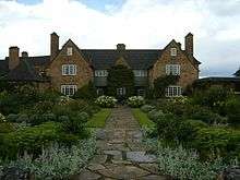 | |||
| Dirleton Village, Manse Road, Auburn, Walled Garden And Retaining Wall | 56°02′53″N 2°46′59″W | Category B | 1338 | | |||
| Dirleton Village, Manse Road, Swiss Cottage | 56°02′45″N 2°46′56″W | Category B | 1344 | | |||
| Dirleton Village, Manse Road, War Memorial | 56°02′51″N 2°46′59″W | Category C(S) | 1345 | | |||
| Eldbottle Wood, Marine Villa | 56°03′49″N 2°48′00″W | Category B | 1347 | | |||
| 14 Fenton Barns Cottages | 56°01′33″N 2°46′51″W | Category C(S) | 1352 | | |||
| Dirleton Road, Invereil House [1] | 56°03′26″N 2°45′47″W[2]) | Category B | 4838 | | |||
| Archerfield, Home Farm | 56°02′38″N 2°48′21″W | Category B | 1521 | | |||
| Gullane, Saltcoats Road, Saltcoats Castle Dovecot | 56°01′39″N 2°49′40″W | Category C(S) | 1369 | | |||
| Gullane, Sandy Loan, St Adrians Episcopal Church | 56°02′08″N 2°50′11″W | Category B | 1371 | | |||
| North Berwick, Abbotsford Road, Carlekemp With Boundary Walls | 56°03′36″N 2°44′43″W | Category A | 1375 | 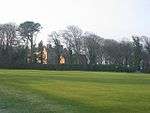 | |||
| North Berwick, Abbotsford Road, Teviotdale, (Formerly Grey Home) | 56°03′29″N 2°44′51″W | Category B | 1379 | | |||
| Fidra Lighthouse With Houses And Walls | 56°04′24″N 2°47′06″W | Category C(S) | 1336 | | |||
| 10, 11 And 12 Fenton Barns Cottages | 56°01′34″N 2°46′51″W | Category B | 1351 | | |||
| Dirleton Village Dirleton Castle, Dovecot, Castle Gate, Tower And North And West Gateways And Boundary Walls | 56°02′48″N 2°46′40″W | Category A | 1525 | .jpg) | |||
| Dirleton Village Main Road, Boonslie | 56°02′42″N 2°46′53″W | Category B | 1530 | | |||
| Gullane, Main Street, Muirfield Lodge | 56°02′18″N 2°49′13″W | Category B | 1362 | | |||
| Gullane, Nisbet Road, Chartwell, With Garage And Gatepiers | 56°02′08″N 2°50′14″W | Category B | 1366 | | |||
| North Berwick, Abbotsford Road, Bunkerhill Lodge, With Gates And Gatepiers | 56°03′27″N 2°45′02″W | Category B | 1374 | | |||
| North Berwick, Williamstone Farmhouse | 56°03′09″N 2°44′26″W | Category B | 1382 | | |||
| Gullane, Duncur Road, Muirfield Gate And Gatehouse/Garage (Formerly Known As The Pleasance) | 56°02′30″N 2°49′17″W | Category A | 1385 | | |||
| Gullane, Erskine Road, Solsgirth | 56°02′20″N 2°49′51″W | Category B | 1387 | | |||
| Kingston Steading With Engine House And Stalk | 56°01′56″N 2°44′52″W | Category B | 1397 | | |||
| 1 And 2, 3 And 4, Fenton Barns Cottages | 56°01′34″N 2°46′57″W | Category C(S) | 1349 | | |||
| 5 And 6, 7 And 8, And 9 Fenton Barns Cottages | 56°01′34″N 2°46′55″W | Category C(S) | 1350 | | |||
| Fenton Barns, Fenbar Garage | 56°01′46″N 2°46′58″W | Category B | 1354 | | |||
| Fenton Barns, Model Farm | 56°01′49″N 2°46′57″W | Category B | 1355 | | |||
| 4-9 (Inclusive Nos) Ferrygate Cottages | 56°03′05″N 2°45′58″W | Category C(S) | 1356 | | |||
| Archerfield, West Lodge | 56°02′29″N 2°48′24″W | Category C(S) | 1519 | | |||
| Dirleton Village, Main Road, Holly Bank | 56°02′43″N 2°46′53″W | Category C(S) | 1533 | | |||
| Archerfield, East Lodge | 56°02′48″N 2°46′58″W | Category B | 1537 | | |||
| Dirleton Village, Main Road, Rose Cottage | 56°02′49″N 2°46′49″W | Category C(S) | 1498 | | |||
| Dirleton Village, Main Road, Dirleton Village School, With Boundary Walls And Gateway | 56°02′37″N 2°47′06″W | Category B | 1499 | | |||
| Gullane, Hummel Road, The Manse Boundary Wall | 56°02′06″N 2°50′21″W | Category B | 1360 | | |||
| Gullane, Main Street, Golf Inn Hotel And Former Stable | 56°02′07″N 2°49′52″W | Category B | 1361 | | |||
| Gullane, Saltcoats Road Saltcoats Castle, Vaulted Chamber And Boundary Walls | 56°01′37″N 2°49′38″W | Category B | 1368 | | |||
| North Berwick, Abbotsford Road, Carlekemp Stables And Gatepiers | 56°03′33″N 2°44′40″W | Category B | 1378 | | |||
| Gullane, Sandy Loan, Purvesholm | 56°02′14″N 2°50′16″W | Category B | 1390 | | |||
| Highfield Farmhouse | 56°02′15″N 2°44′02″W | Category C(S) | 1394 | | |||
| New Mains North And West Ranges With Engine House And Stalk | 56°01′23″N 2°47′32″W | Category B | 1399 | | |||
| East Fenton, Farm House | 56°01′25″N 2°46′14″W | Category B | 1346 | | |||
| Gullane, Hill Road, Whatton Lodge | 56°02′10″N 2°50′32″W | Category B | 1358 | | |||
| 7 Archerfield Estate | 56°02′41″N 2°48′13″W | Category B | 1520 | 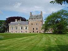 | |||
| Dirleton Village, Church Session House (Former Gate House) And Former Mortuary | 56°02′53″N 2°47′02″W | Category B | 1527 | | |||
| Dirleton Village, Dirleton Road, Cedar Grove | 56°02′54″N 2°46′25″W | Category C(S) | 1528 | | |||
| Dirleton Village, Main Road, Ivy Bank | 56°02′41″N 2°46′55″W | Category B | 1534 | | |||
| Dirleton Village, Main Road, Vine Cottage | 56°02′50″N 2°46′40″W | Category B | 1500 | | |||
| Gullane, Main Street, Parish Church Hall | 56°02′06″N 2°49′50″W | Category A | 1363 | | |||
| North Berwick, Abbotsford Road, Carlekemp Lodge With Gates And Gatepiers | 56°03′31″N 2°44′43″W | Category A | 1376 | | |||
| North Berwick, Abbotsford Road, Carlekemp Engine Cottage | 56°03′32″N 2°44′52″W | Category B | 1377 | | |||
| 1 And 2, 11 And 12 West Fenton Cottages With Retaining Wall | 56°01′36″N 2°48′07″W | Category B | 1402 | | |||
| West Fenton Farmhouse | 56°01′35″N 2°48′22″W | Category B | 1404 | | |||
| Archerfield With Pavilion Wings | 56°02′50″N 2°47′43″W | Category A | 1536 | 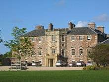 | |||
| Gullane, Main Street, The Smithy | 56°02′04″N 2°49′57″W | Category B | 1365 | | |||
| Gullane, Hill Road, Whim Lodge And The Bents | 56°02′13″N 2°50′15″W | Category C(S) | 1388 | | |||
| Gullane, Whim Road, Seton Court | 56°01′59″N 2°50′33″W | Category B | 1391 | | |||
| Gullane, Whim Road, Whiteholm | 56°02′00″N 2°50′30″W | Category B | 1393 | | |||
| Kingston Farmhouse With Walled Garden And Summer House | 56°01′49″N 2°44′32″W | Category B | 1395 | | |||
| North Berwick, Abbotsford Road, Bunkerhill (Bunkershill) And Boundary Walls | 56°03′27″N 2°45′07″W | Category A | 1400 | | |||
| West Fenton Steading And Stalk | 56°01′36″N 2°48′24″W | Category B | 1405 | | |||
| Ferrygate Farmhouse With Gatepiers, Boundary Walls, East And West Steading Ranges | 56°03′03″N 2°45′45″W | Category B | 1335 | | |||
| Dirleton Village, Manse Road, The Old Manse | 56°02′46″N 2°46′56″W | Category B | 1342 | | |||
| Eldbottle Wood, Marine Villa Cottage | 56°03′48″N 2°48′04″W | Category C(S) | 1348 | | |||
| Dirleton Road, Invereil Coach-House | 56°03′23″N 2°45′41″W | Category C(S) | 1523 | | |||
| Dirleton Road Invereil Lodge, Quadrant Walls And Gatepiers | 56°03′10″N 2°45′42″W | Category C(S) | 1524 | | |||
| Dirleton Village, Dirleton Parish Church, Gateway And Graveyard Walls | 56°02′54″N 2°47′02″W | Category A | 1526 | 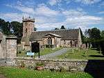 | |||
| Gullane, Saltcoats Road, Saltcoats Market Garden House | 56°01′38″N 2°49′40″W | Category B | 1370 | | |||
| North Berwick, 1 And 2 Williamstone Cottages | 56°03′11″N 2°44′26″W | Category C(S) | 1381 | | |||
| Hill Road, Tern Cottage, (Formerly Coldstones Cottage) Including Terrace, Gateways And Boundary Walls | 56°02′09″N 2°50′36″W | Category B | 1389 | | |||
| Gullane, Whim Road, The Whim | 56°02′03″N 2°50′39″W | Category C(S) | 1392 | |
Key
The scheme for classifying buildings in Scotland is:
- Category A: "buildings of national or international importance, either architectural or historic; or fine, little-altered examples of some particular period, style or building type."[3]
- Category B: "buildings of regional or more than local importance; or major examples of some particular period, style or building type, which may have been altered."[3]
- Category C: "buildings of local importance; lesser examples of any period, style, or building type, as originally constructed or moderately altered; and simple traditional buildings which group well with other listed buildings."[3]
In March 2016 there were 47,288 listed buildings in Scotland. Of these, 8% were Category A, and 50% were Category B, with the remaining 42% being Category C.[4]
gollark: Great!
gollark: Are the .5 games meant to go really fast, then?
gollark: CEASE THINE ABUSIVE DELETINATION OF MINE COMMENTATIONS!
gollark: Besides, you might forget about SCP-055.
gollark: But you might posess anti-bee/anti-me/anti-SCP-055 bias.
Notes
- Sometimes known as OSGB36, the grid reference (where provided) is based on the British national grid reference system used by the Ordnance Survey.
• "Guide to National Grid". Ordnance Survey. Retrieved 2007-12-12.
• "Get-a-map". Ordnance Survey. Retrieved 2007-12-17. - Historic Environment Scotland assign a unique alphanumeric identifier to each designated site in Scotland, for listed buildings this always begins with "LB", for example "LB12345".
References
- All entries, addresses and coordinates are based on data from Historic Scotland. This data falls under the Open Government Licence
- "Invereil House" (PDF).
- "Invereil House" (PDF).
- "What is Listing?". Historic Environment Scotland. Retrieved 29 May 2018.
- Scotland's Historic Environment Audit 2016 (PDF). Historic Environment Scotland and the Built Environment Forum Scotland. pp. 15–16. Retrieved 29 May 2018.
This article is issued from Wikipedia. The text is licensed under Creative Commons - Attribution - Sharealike. Additional terms may apply for the media files.