List of listed buildings in Darvel, East Ayrshire
List
| Name | Location | Date Listed | Grid Ref. [note 1] | Geo-coordinates | Notes | LB Number [note 2] | Image |
|---|---|---|---|---|---|---|---|
| Ranoldcoup Bridge | 55°36′22″N 4°16′55″W | Category B | 24485 |  | |||
| 1-5 (Inclusive Nos) Hastings Square | 55°36′34″N 4°16′55″W | Category B | 24480 | | |||
| Dalquharn | 55°36′24″N 4°17′22″W | Category C(S) | 24486 | | |||
| 1 Mair's Road Former Fish Farm | 55°36′27″N 4°16′55″W | Category B | 24489 | | |||
| Mair's Free School, Front Boundary Walls, Gatepiers And Gates Ranoldcoup Road | 55°36′29″N 4°16′57″W | Category B | 24495 | | |||
| Nos. 6, 7, 8 And 9 Hastings Square | 55°36′34″N 4°17′00″W | Category B | 24481 | 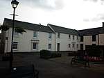 | |||
| No. 106 East Main Street | 55°36′38″N 4°16′30″W | Category B | 24484 | | |||
| The Black Bull Hotel, Hastings | 55°36′35″N 4°16′59″W | Category B | 24482 | 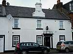 | |||
| Darvel Church | 55°36′33″N 4°16′57″W | Category B | 24479 | 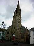 | |||
| Railway Viaduct Over Glen Water | 55°36′48″N 4°16′24″W | Category B | 24487 | | |||
| 1, 3 Ranaldcoup Road Former Co-Op Building | 55°36′34″N 4°16′54″W | Category B | 24494 | | |||
| Turf Hotel, Main Street | 55°36′35″N 4°17′07″W | Category B | 24483 | | |||
| Greenbank | 55°36′28″N 4°15′59″W | Category B | 24488 | | |||
| 4 Mair's Road | 55°36′28″N 4°17′01″W | Category B | 24490 | | |||
| 2, 4, 6 East Main Street And Ranaldcoup Road Co-Op Building | 55°36′34″N 4°16′54″W | Category C(S) | 24491 | | |||
| East Main Street And Kirkland Road Kirkland Park | 55°36′44″N 4°16′29″W | Category B | 24492 | | |||
| 10 12 West Main Street Darvel Town Hall And Library | 55°36′36″N 4°16′56″W | Category B | 24493 | |
Key
The scheme for classifying buildings in Scotland is:
- Category A: "buildings of national or international importance, either architectural or historic; or fine, little-altered examples of some particular period, style or building type."[1]
- Category B: "buildings of regional or more than local importance; or major examples of some particular period, style or building type, which may have been altered."[1]
- Category C: "buildings of local importance; lesser examples of any period, style, or building type, as originally constructed or moderately altered; and simple traditional buildings which group well with other listed buildings."[1]
In March 2016 there were 47,288 listed buildings in Scotland. Of these, 8% were Category A, and 50% were Category B, with the remaining 42% being Category C.[2]
gollark: The madman behind it (@Incin or something) made a HTML/CSS parser/renderer or something and made the shop use it.
gollark: I prefer Xenon. It's more flexible though configuration is harder.
gollark: You should not work on a shop if you need someone to explain the docs to you and write the code for you.
gollark: That is what I *said*.
gollark: <@186486131565527040> A shop is probably not a great project for those newish to CC.
Notes
- Sometimes known as OSGB36, the grid reference (where provided) is based on the British national grid reference system used by the Ordnance Survey.
• "Guide to National Grid". Ordnance Survey. Retrieved 12 December 2007.
• "Get-a-map". Ordnance Survey. Retrieved 17 December 2007. - Historic Environment Scotland assign a unique alphanumeric identifier to each designated site in Scotland, for listed buildings this always begins with "LB", for example "LB12345".
References
- All entries, addresses and coordinates are based on data from Historic Scotland. This data falls under the Open Government Licence
- "What is Listing?". Historic Environment Scotland. Retrieved 29 May 2018.
- Scotland's Historic Environment Audit 2016 (PDF). Historic Environment Scotland and the Built Environment Forum Scotland. pp. 15–16. Retrieved 29 May 2018.
This article is issued from Wikipedia. The text is licensed under Creative Commons - Attribution - Sharealike. Additional terms may apply for the media files.