List of listed buildings in Dalgety, Fife
List
| Name | Location | Date Listed | Grid Ref. [note 1] | Geo-coordinates | Notes | LB Number [note 2] | Image |
|---|---|---|---|---|---|---|---|
| St Colme, Coachhouse And Walled Garden, Including Gates | 56°02′40″N 3°18′52″W | Category B | 6616 |  | |||
| Donibristle House | 56°01′53″N 3°20′58″W | Category A | 3647 | | |||
| Mount Laura Tower | 56°03′21″N 3°20′18″W | Category C(S) | 3656 | | |||
| Donibristle Ice-House | 56°01′59″N 3°21′20″W | Category B | 3651 | | |||
| Fordell Chapel | 56°03′12″N 3°22′19″W | Category A | 3653 | | |||
| Donibristle Chapel | 56°01′50″N 3°21′08″W | Category A | 3650 |  | |||
| Fordell Castle | 56°03′13″N 3°22′16″W | Category A | 3652 | | |||
| Cockairnie House | 56°03′09″N 3°20′09″W | Category B | 3657 | | |||
| 'The Monk's Cave', Charles Hill, St. Colme House Policies | 56°02′21″N 3°18′31″W | Category B | 3661 | | |||
| 'Ardmhor' (Formerly Dalgety Manse) | 56°02′43″N 3°20′06″W | Category C(S) | 3665 | | |||
| Vantage Farm Fordell Estate Coach House, Dairy, Dairy Cottage, Granary And Gate Piers | 56°03′21″N 3°21′55″W | Category C(S) | 3662 | | |||
| St Colme House Sundial | 56°02′39″N 3°18′48″W | Category B | 6617 | | |||
| Fordell Sun-Dial | 56°03′14″N 3°22′15″W | Category C(S) | 3654 | | |||
| Otterston Tower | 56°03′11″N 3°20′31″W | Category C(S) | 3659 | | |||
| St. Bridget's Church | 56°02′23″N 3°20′04″W | Category A | 3667 | 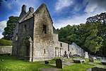 | |||
| Donibristle Estate Boundary Wall And Fordell Railway | 56°02′21″N 3°21′36″W | Category C(S) | 43861 | | |||
| Dalgety Bay, Gardens Cottage | 56°02′13″N 3°21′28″W | Category C(S) | 3648 | | |||
| Lochside Cottages, Otterston Loch | 56°03′09″N 3°20′20″W | Category C(S) | 3658 | | |||
| Vantage Farm Fordell Estate Dovecot | 56°03′19″N 3°21′56″W | Category B | 3663 | | |||
| Dalgety Kirk | 56°02′48″N 3°20′20″W | Category B | 3664 | | |||
| Barns Farmhouse | 56°02′39″N 3°20′18″W | Category C(S) | 3666 | | |||
| St Colme House | 56°02′40″N 3°18′49″W | Category B | 6615 | | |||
| Watch-House, St. Bridget's Churchyard | 56°02′23″N 3°20′05″W | Category B | 3646 | | |||
| Donibristle Stables | 56°01′57″N 3°20′46″W | Category B | 3649 | | |||
| Ansonhill House | 56°05′00″N 3°21′42″W | Category B | 3655 | | |||
| Markfield Tower | 56°03′00″N 3°20′37″W | Category C(S) | 3660 | |
Key
The scheme for classifying buildings in Scotland is:
- Category A: "buildings of national or international importance, either architectural or historic; or fine, little-altered examples of some particular period, style or building type."[1]
- Category B: "buildings of regional or more than local importance; or major examples of some particular period, style or building type, which may have been altered."[1]
- Category C: "buildings of local importance; lesser examples of any period, style, or building type, as originally constructed or moderately altered; and simple traditional buildings which group well with other listed buildings."[1]
In March 2016 there were 47,288 listed buildings in Scotland. Of these, 8% were Category A, and 50% were Category B, with the remaining 42% being Category C.[2]
gollark: No trigonometry somehow, just vector maths.
gollark: The speed of light is such that if they were off by a fraction of a second the distances would probably be unusably wrong.
gollark: Then you use the known position of the satellites and distances to each to work out where you are.
gollark: GPS operates on multilateration. It works out the distance to each satellite based on ~~its computed orbital position and~~ differences in time to receive the signal from each satellite.
gollark: No it isn't. That would entirely break it.
See also
Notes
- Sometimes known as OSGB36, the grid reference (where provided) is based on the British national grid reference system used by the Ordnance Survey.
• "Guide to National Grid". Ordnance Survey. Retrieved 2007-12-12.
• "Get-a-map". Ordnance Survey. Retrieved 2007-12-17. - Historic Environment Scotland assign a unique alphanumeric identifier to each designated site in Scotland, for listed buildings this always begins with "LB", for example "LB12345".
References
- All entries, addresses and coordinates are based on data from Historic Scotland. This data falls under the Open Government Licence
- "What is Listing?". Historic Environment Scotland. Retrieved 29 May 2018.
- Scotland's Historic Environment Audit 2016 (PDF). Historic Environment Scotland and the Built Environment Forum Scotland. pp. 15–16. Retrieved 29 May 2018.
This article is issued from Wikipedia. The text is licensed under Creative Commons - Attribution - Sharealike. Additional terms may apply for the media files.