List of listed buildings in Cumnock And Holmhead, East Ayrshire
This is a list of listed buildings in the parish of Cumnock and Holmhead, in East Ayrshire, Scotland.
List
| Name | Location | Date Listed | Grid Ref. [note 1] | Geo-coordinates | Notes | LB Number [note 2] | Image |
|---|---|---|---|---|---|---|---|
| Old Cumnock Old Church | 55°27′15″N 4°15′58″W | Category B | 24092 | 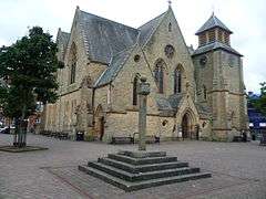 | |||
| The Snug Bar The Square | 55°27′16″N 4°15′59″W | Category C(S) | 24103 |  | |||
| The Royal Hotel 44, 45, 46 The Square | 55°27′16″N 4°15′56″W | Category C(S) | 24107 | | |||
| The Craighead Inn | 55°27′15″N 4°15′54″W | Category C(S) | 24108 | | |||
| No 15 Glaisnock Street | 55°27′16″N 4°15′53″W | Category C(S) | 24113 | | |||
| No 18 Glaisnock Street | 55°27′13″N 4°15′54″W | Category C(S) | 24116 | | |||
| Congregational Church And Manse Auchinleck Road | 55°27′20″N 4°16′07″W | Category C(S) | 24130 | | |||
| Bank (Or Templand) Railway Viaduct Over Lugar Water In Woodroad Park | 55°27′31″N 4°15′24″W | Category A | 24133 |  | |||
| No 22 The Square | 55°27′15″N 4°15′59″W | Category B | 24101 | | |||
| Cumnock, 65 And 67 Glaisnock Street, Royal Bank Of Scotland | 55°27′12″N 4°15′51″W | Category B | 24111 | | |||
| Crichton Church Of Scotland Ayr Road | 55°27′11″N 4°15′57″W | Category B | 24123 | | |||
| Nos 1, 2 The Square | 55°27′14″N 4°15′56″W | Category C(S) | 24094 | | |||
| The Mercat Hotel, Formerly The Black Bull Hotel, The Square | 55°27′16″N 4°15′56″W | Category B | 24106 | | |||
| Cumnock, Glaisnock Street, Dumfries Arms Hotel | 55°27′10″N 4°15′50″W | Category B | 24112 | | |||
| No 17 Glaisnock Street | 55°27′15″N 4°15′54″W | Category C(S) | 24114 | | |||
| Nos 12-16 Glaisnock Street | 55°27′14″N 4°15′54″W | Category C(S) | 24115 | | |||
| Cumnock, 21 Ayr Road, Including Gatepiers And Boundary Wall | 55°27′08″N 4°15′57″W | Category B | 24121 | | |||
| Strathcylde Regional Supplies Department (Former United Session Church), Tanyard | 55°27′10″N 4°16′02″W | Category C(S) | 24125 | | |||
| Former Railway Viaduct Now Footbridge, Murray Park | 55°26′55″N 4°15′24″W | Category B | 24134 | | |||
| Nos 18, 19, 20 The Square | 55°27′14″N 4°15′59″W | Category C(S) | 24099 | | |||
| No 38 The Square | 55°27′17″N 4°15′57″W | Category C(S) | 24105 | | |||
| Town Hall, Glaisnock Street | 55°27′08″N 4°15′50″W | Category C(S) | 24119 | | |||
| Nos 38-42 Ayr Road | 55°27′11″N 4°15′55″W | Category B | 24122 | | |||
| Lugar (Or Stepends) Bridge Over Lugar Water | 55°27′18″N 4°16′04″W | Category B | 24129 | | |||
| Mercat Cross, The Square | 55°27′14″N 4°15′58″W | Category A | 24093 | 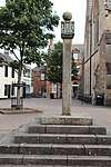 | |||
| The Sun Inn, The Square | 55°27′15″N 4°15′59″W | Category B | 24102 | | |||
| Cumnock, 61 And 63 Glaisnock Street | 55°27′12″N 4°15′50″W | Category B | 24110 | | |||
| No 20 24 Glaisnock Street | 55°27′13″N 4°15′54″W | Category C(S) | 24117 | | |||
| Nos 1-3 Ayr Road | 55°27′12″N 4°15′52″W | Category C(S) | 24118 | | |||
| Broomfield, Auchinleck Road | 55°27′17″N 4°16′25″W | Category B | 24131 | | |||
| Nos 9, 10, 11 The Square | 55°27′14″N 4°15′58″W | Category C(S) | 24098 | | |||
| No 21 The Square | 55°27′15″N 4°15′59″W | Category C(S) | 24100 | | |||
| The Clydesdale Bank The Square | 55°27′16″N 4°15′58″W | Category B | 24104 | | |||
| Strathclyde Regional Council Area Office, Off Lugar Street | 55°27′20″N 4°15′58″W | Category C(S) | 24126 | | |||
| Nos 3, 4 5 The Square Gospel Hall | 55°27′14″N 4°15′57″W | Category B | 24095 | | |||
| No 6 The Square | 55°27′14″N 4°15′57″W | Category B | 24096 | | |||
| St John's R.C. Church Glaisnock Street | 55°26′58″N 4°15′41″W | Category B | 24120 | | |||
| Graveyard Barrhill Road | 55°27′20″N 4°15′45″W | Category C(S) | 24132 | | |||
| 3 Lugar Street, The Baird Institute | 55°27′16″N 4°16′01″W | Category C(S) | 50889 | | |||
| No 7, 8 The Square | 55°27′14″N 4°15′58″W | Category B | 24097 | | |||
| Cumnock, 55 And 57 Glaisnock Street | 55°27′13″N 4°15′51″W | Category C(S) | 24109 | | |||
| Riverside, Lugar Street | 55°27′18″N 4°16′02″W | Category C(S) | 24128 | | |||
| Auchinleck Road Lochnorris | 55°27′18″N 4°16′21″W | Category B | 24135 | |
Key
The scheme for classifying buildings in Scotland is:
- Category A: "buildings of national or international importance, either architectural or historic; or fine, little-altered examples of some particular period, style or building type."[1]
- Category B: "buildings of regional or more than local importance; or major examples of some particular period, style or building type, which may have been altered."[1]
- Category C: "buildings of local importance; lesser examples of any period, style, or building type, as originally constructed or moderately altered; and simple traditional buildings which group well with other listed buildings."[1]
In March 2016 there were 47,288 listed buildings in Scotland. Of these, 8% were Category A, and 50% were Category B, with the remaining 42% being Category C.[2]
gollark: I was thinking that hepta*grams* should be dangerous somehow, but the obvious way of "it lets you summon demons" is kind of overplayed?
gollark: I should do apioforms next, or expand on the Royal Astrothaumic Institute, engineers, Memetics War, heptagrams or wheels.
gollark: <https://discordapp.com/oauth2/authorize?&client_id=509849474647064576&scope=bot&permissions=68608>
gollark: This server should have autobotrobot for non-evil reasons.
gollark: Probably!
Notes
- Sometimes known as OSGB36, the grid reference (where provided) is based on the British national grid reference system used by the Ordnance Survey.
• "Guide to National Grid". Ordnance Survey. Retrieved 12 December 2007.
• "Get-a-map". Ordnance Survey. Retrieved 17 December 2007. - Historic Environment Scotland assign a unique alphanumeric identifier to each designated site in Scotland, for listed buildings this always begins with "LB", for example "LB12345".
References
- All entries, addresses and coordinates are based on data from Historic Scotland. This data falls under the Open Government Licence
- "What is Listing?". Historic Environment Scotland. Retrieved 29 May 2018.
- Scotland's Historic Environment Audit 2016 (PDF). Historic Environment Scotland and the Built Environment Forum Scotland. pp. 15–16. Retrieved 29 May 2018.
This article is issued from Wikipedia. The text is licensed under Creative Commons - Attribution - Sharealike. Additional terms may apply for the media files.