List of listed buildings in Crimond, Aberdeenshire
List
| Name | Location | Date Listed | Grid Ref. [note 1] | Geo-coordinates | Notes | LB Number [note 2] | Image |
|---|---|---|---|---|---|---|---|
| Old School And Schoolhouse, Crimond | 57°36′05″N 1°54′49″W | Category B | 3029 |  | |||
| Rattray House, Outbuildings Walled Gardens, And 3 Sets Of Gatepiers Attached Thereto | 57°35′43″N 1°50′45″W | Category B | 3039 | | |||
| Middleton Of Rattray, Farmhouse | 57°36′07″N 1°50′43″W | Category C(S) | 3036 | | |||
| Avaig (Former Manse Of Crimond) | 57°36′02″N 1°54′42″W | Category C(S) | 3031 | | |||
| Parish Church Of Crimond Including Enclosing Walls Railings And Gates | 57°36′03″N 1°54′41″W | Category A | 3028 | 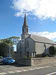 | |||
| Haddo House Mains Of Haddo | 57°36′16″N 1°52′19″W | Category A | 3034 | | |||
| Rattray House Lodge And Gates | 57°35′38″N 1°51′26″W | Category B | 3037 | | |||
| Mill Of Crimond | 57°36′34″N 1°56′04″W | Category C(S) | 3043 | | |||
| Old Parish Church Of Crimond And Graveyard | 57°36′29″N 1°54′51″W | Category B | 3030 | | |||
| Hillhead Farmhouse | 57°36′15″N 1°53′50″W | Category C(S) | 3032 | | |||
| Dipplebrae Farmhouse | 57°36′01″N 1°52′10″W | Category C(S) | 3033 | | |||
| Mains Of Haddo Steading | 57°36′16″N 1°52′18″W | Category C(S) | 3035 | | |||
| Rattray House | 57°35′43″N 1°50′46″W | Category B | 3038 | | |||
| Rattray House Home Farm And 2 Houses (One Unoccupied 1967) | 57°35′38″N 1°50′45″W | Category B | 3040 | | |||
| Rattray Head Lighthouse The Ron | 57°36′36″N 1°48′59″W | Category B | 3042 | | |||
| Rattray, St Mary's Chapel And Graveyard | 57°36′28″N 1°51′33″W | Category B | 46 | | |||
| Rattray House, Laundry (Disused) N. Of House | 57°35′46″N 1°50′45″W | Category C(S) | 3041 | |
Key
The scheme for classifying buildings in Scotland is:
- Category A: "buildings of national or international importance, either architectural or historic; or fine, little-altered examples of some particular period, style or building type."[1]
- Category B: "buildings of regional or more than local importance; or major examples of some particular period, style or building type, which may have been altered."[1]
- Category C: "buildings of local importance; lesser examples of any period, style, or building type, as originally constructed or moderately altered; and simple traditional buildings which group well with other listed buildings."[1]
In March 2016 there were 47,288 listed buildings in Scotland. Of these, 8% were Category A, and 50% were Category B, with the remaining 42% being Category C.[2]
gollark: Added to your robotic profile.
gollark: That information is classified to POTAT-O7 level.
gollark: <@738361430763372703> *You* should "join" heavserver!
gollark: I have actual service files.
gollark: It would be five but icecast actually bad and not good
Notes
- Sometimes known as OSGB36, the grid reference (where provided) is based on the British national grid reference system used by the Ordnance Survey.
• "Guide to National Grid". Ordnance Survey. Retrieved 2007-12-12.
• "Get-a-map". Ordnance Survey. Retrieved 2007-12-17. - Historic Environment Scotland assign a unique alphanumeric identifier to each designated site in Scotland, for listed buildings this always begins with "LB", for example "LB12345".
References
- All entries, addresses and coordinates are based on data from Historic Scotland. This data falls under the Open Government Licence
- "What is Listing?". Historic Environment Scotland. Retrieved 29 May 2018.
- Scotland's Historic Environment Audit 2016 (PDF). Historic Environment Scotland and the Built Environment Forum Scotland. pp. 15–16. Retrieved 29 May 2018.
This article is issued from Wikipedia. The text is licensed under Creative Commons - Attribution - Sharealike. Additional terms may apply for the media files.