List of listed buildings in Crichton, Midlothian
List
| Name | Location | Date Listed | Grid Ref. [note 1] | Geo-coordinates | Notes | LB Number [note 2] | Image |
|---|---|---|---|---|---|---|---|
| Crichton Castle, Stables | 55°50′20″N 2°59′29″W | Category A | 755 | 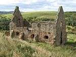 | |||
| Ford, Ford House And Walled Garden | 55°52′07″N 2°58′39″W | Category A | 756 | 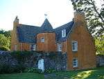 | |||
| Crichton House, East And West Wings | 55°51′06″N 2°57′34″W | Category A | 757 |  | |||
| Crichton, Crichton Mains | 55°50′50″N 2°58′46″W | Category B | 47759 | 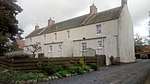 | |||
| Pathhead, 7 Main Street | 55°52′08″N 2°58′17″W | Category C(S) | 47763 | | |||
| Pathhead, 23 Main Street, Boundary Wall And Wrought-Iron Railings | 55°52′07″N 2°58′13″W | Category C(S) | 47764 | | |||
| Saughland Farm Cottages And Boundary Walls | 55°50′23″N 2°56′00″W | Category C(S) | 47771 | | |||
| Tynebank And Cottages | 55°51′18″N 2°58′54″W | Category B | 47772 | | |||
| Crichton Castle | 55°50′22″N 2°59′30″W | Category A | 754 | 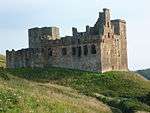 | |||
| Costerton, Former Costerton House, Doocot | 55°51′35″N 2°54′04″W | Category C(S) | 758 | | |||
| Crichton Village, Cottages 10-14 (Inclusive Numbers) | 55°50′49″N 2°58′59″W | Category B | 765 | | |||
| Pathhead, 75-77 (Odd Numbers) Main Street | 55°52′03″N 2°58′02″W | Category C(S) | 47767 | | |||
| Cakemuir Castle, Including Walled Garden, Stable Range And Cottage | 55°49′17″N 2°56′20″W | Category B | 764 | | |||
| Tynehead, Station Cottage | 55°49′19″N 2°58′09″W | Category C(S) | 47773 | | |||
| 12 Fala Dam, White House | 55°50′38″N 2°54′49″W | Category C(S) | 760 | | |||
| 8 Fala Dam, The Dam House | 55°50′38″N 2°54′50″W | Category C(S) | 112 | | |||
| Crichton Manse Including Garden Buildings, Railings And Garden Walls | 55°50′39″N 2°59′28″W | Category B | 6681 | | |||
| Pathhead, 71-73 (Odd Numbers) Main Street | 55°52′03″N 2°58′02″W | Category C(S) | 5092 | | |||
| 10 Fala Dam, Laggan Cottage | 55°50′38″N 2°54′50″W | Category C(S) | 759 | | |||
| Longfaugh Farm House | 55°50′47″N 2°56′47″W | Category C(S) | 763 | | |||
| Costerton, Former Costerton House Icehouse | 55°51′35″N 2°54′09″W | Category B | 47757 | | |||
| Pathhead, 39 Main Street | 55°52′06″N 2°58′08″W | Category C(S) | 47765 | | |||
| Pathhead, 57 Main Street, Grey's House | 55°52′05″N 2°58′05″W | Category C(S) | 47766 | | |||
| Pathhead, 119 Main Street | 55°51′58″N 2°57′56″W | Category C(S) | 47768 | | |||
| Pathhead, 172 Main Street | 55°51′53″N 2°57′52″W | Category C(S) | 47770 | | |||
| Costerton, Costerton House (Former Gardener's Cottage) And Walled Garden | 55°51′31″N 2°54′15″W | Category C(S) | 47756 | | |||
| Pathhead, 159 Main Street | 55°51′55″N 2°57′51″W | Category C(S) | 47769 | | |||
| Lothian Bridge, Tyne Valley | 55°52′12″N 2°58′29″W | Category A | 5090 | 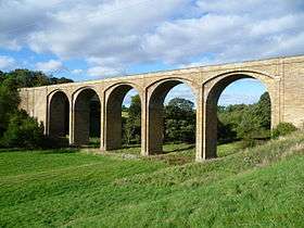 | |||
| Crichton Kirk (Formerly Collegiate Church Of S.S. Mary And Kentigern) Including Graveyard | 55°50′37″N 2°59′25″W | Category A | 753 | 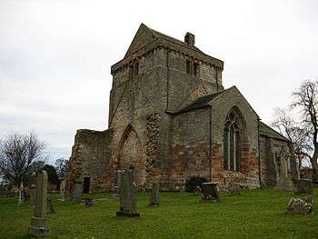 | |||
| 14 Fala Dam, Falaburn House | 55°50′38″N 2°54′47″W | Category C(S) | 761 | | |||
| Pathhead, 47 Main Street | 55°52′05″N 2°58′07″W | Category C(S) | 5091 | | |||
| Bridge, Fala Dam Burn | 55°50′39″N 2°54′46″W | Category C(S) | 762 | | |||
| Crichton Limekilns, Pathhead | 55°50′37″N 2°58′15″W | Category C(S) | 47758 | |
Key
The scheme for classifying buildings in Scotland is:
- Category A: "buildings of national or international importance, either architectural or historic; or fine, little-altered examples of some particular period, style or building type."[1]
- Category B: "buildings of regional or more than local importance; or major examples of some particular period, style or building type, which may have been altered."[1]
- Category C: "buildings of local importance; lesser examples of any period, style, or building type, as originally constructed or moderately altered; and simple traditional buildings which group well with other listed buildings."[1]
In March 2016 there were 47,288 listed buildings in Scotland. Of these, 8% were Category A, and 50% were Category B, with the remaining 42% being Category C.[2]
gollark: ++exec```pythonraise Exception("Oops")```
gollark: Let me guess, that was 1000 zero width spaces?
gollark: ++delete π
gollark: ++delete 🌵
gollark: I should really make it escape formatting and limit entry length.
Notes
- Sometimes known as OSGB36, the grid reference (where provided) is based on the British national grid reference system used by the Ordnance Survey.
• "Guide to National Grid". Ordnance Survey. Retrieved 2007-12-12.
• "Get-a-map". Ordnance Survey. Retrieved 2007-12-17. - Historic Environment Scotland assign a unique alphanumeric identifier to each designated site in Scotland, for listed buildings this always begins with "LB", for example "LB12345".
References
- All entries, addresses and coordinates are based on data from Historic Scotland. This data falls under the Open Government Licence
- "What is Listing?". Historic Environment Scotland. Retrieved 29 May 2018.
- Scotland's Historic Environment Audit 2016 (PDF). Historic Environment Scotland and the Built Environment Forum Scotland. pp. 15–16. Retrieved 29 May 2018.
This article is issued from Wikipedia. The text is licensed under Creative Commons - Attribution - Sharealike. Additional terms may apply for the media files.