List of listed buildings in Creich, Fife
List
| Name | Location | Date Listed | Grid Ref. [note 1] | Geo-coordinates | Notes | LB Number [note 2] | Image |
|---|---|---|---|---|---|---|---|
| The Beeches | 56°22′32″N 3°05′56″W | Category C(S) | 2179 |  | |||
| Creich Castle, Tower | 56°22′44″N 3°05′21″W | Category B | 2141 | | |||
| Annfield, Village Shop Row | 56°22′30″N 3°05′58″W | Category C(S) | 2176 | | |||
| "Druid Circle" Manse Of Creich | 56°22′36″N 3°06′14″W | Category B | 2139 | | |||
| Creich Castle | 56°22′44″N 3°05′19″W | Category B | 2140 | | |||
| Old Smiddy House Luthrie | 56°21′50″N 3°05′03″W | Category C(S) | 2144 | | |||
| Carphin House | 56°21′47″N 3°06′09″W | Category C(S) | 2151 | | |||
| Carphin Doocot | 56°21′52″N 3°06′06″W | Category B | 2152 | | |||
| Burnside, Formerly Hayslop | 56°22′31″N 3°05′52″W | Category C(S) | 2155 | | |||
| Cherrybank | 56°22′36″N 3°05′48″W | Category C(S) | 2158 | | |||
| Brunton Village, Village Shop Property | 56°22′30″N 3°05′58″W | Category C(S) | 4281 | | |||
| Manse Of Creich | 56°22′34″N 3°06′12″W | Category B | 2138 | | |||
| Parbroath House | 56°20′49″N 3°05′43″W | Category B | 2146 | | |||
| Brunton Village, Old Weaving Shed Opposite Village Shop | 56°22′30″N 3°05′58″W | Category C(S) | 4282 | | |||
| Carphin House, Lodge And Gates | 56°21′41″N 3°05′39″W | Category C(S) | 2150 | | |||
| Creich Castle Doocot | 56°22′45″N 3°05′23″W | Category A | 2173 | | |||
| Weavers' Sheds Property Of Metcalfe, The Beeches | 56°22′33″N 3°05′56″W | Category C(S) | 2180 | | |||
| Creich Parish Kirk Stables And Gighouse | 56°22′01″N 3°05′23″W | Category C(S) | 2143 | | |||
| Parbroath Castle | 56°20′46″N 3°05′57″W | Category C(S) | 2147 | | |||
| Parbroath Castle Doocot | 56°20′51″N 3°05′59″W | Category B | 2148 | | |||
| Lilac Cottage | 56°22′31″N 3°05′51″W | Category C(S) | 2156 | | |||
| The Croft (Revalski) | 56°22′33″N 3°05′52″W | Category C(S) | 2157 | | |||
| School Row Comprising Former Free School Now Mchaven And Mr Young's Cottages | 56°22′30″N 3°05′55″W | Category C(S) | 2174 | | |||
| Dendale Farm House | 56°22′30″N 3°05′56″W | Category C(S) | 2175 | | |||
| Reid, Village Shop Row | 56°22′30″N 3°05′57″W | Category C(S) | 2177 | | |||
| Detached Out-Building, Village Shop Row (Mr Reid's) | 56°22′30″N 3°05′56″W | Category C(S) | 2178 | | |||
| Balmeadowside Farm House | 56°21′04″N 3°06′23″W | Category C(S) | 2149 | | |||
| Old Parish Kirk Of St Devenic And Churchyard, Creich (Excluding Modern Cemetery Extension) | 56°22′48″N 3°05′30″W | Category B | 2153 | | |||
| Anzac, Brunton | 56°22′31″N 3°05′53″W | Category C(S) | 2154 | | |||
| Creich Farm Steading (Mountquhanie Farms) | 56°22′44″N 3°05′24″W | Category B | 43883 | | |||
| Creich Parish Kirk Including Churchyard, Walls And Gates | 56°22′02″N 3°05′22″W | Category B | 2142 | 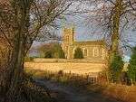 | |||
| Lower Luthrie House (Luthrie House On Map) | 56°21′44″N 3°04′58″W | Category C(S) | 2145 | |
Key
The scheme for classifying buildings in Scotland is:
- Category A: "buildings of national or international importance, either architectural or historic; or fine, little-altered examples of some particular period, style or building type."[1]
- Category B: "buildings of regional or more than local importance; or major examples of some particular period, style or building type, which may have been altered."[1]
- Category C: "buildings of local importance; lesser examples of any period, style, or building type, as originally constructed or moderately altered; and simple traditional buildings which group well with other listed buildings."[1]
In March 2016 there were 47,288 listed buildings in Scotland. Of these, 8% were Category A, and 50% were Category B, with the remaining 42% being Category C.[2]
gollark: At least spoil it tomorrow?
gollark: I suppose so. Or read the code to spoil it. But don't.
gollark: You'll get an achievement if it does activate (take *that* speedrunners!) anyway.
gollark: It's actually client side triggered. But it's set to UTC to remove ambiguity. Probably.
gollark: I don't believe in religion, so using "anno domini" would be weird.
See also
Notes
- Sometimes known as OSGB36, the grid reference (where provided) is based on the British national grid reference system used by the Ordnance Survey.
• "Guide to National Grid". Ordnance Survey. Retrieved 2007-12-12.
• "Get-a-map". Ordnance Survey. Retrieved 2007-12-17. - Historic Environment Scotland assign a unique alphanumeric identifier to each designated site in Scotland, for listed buildings this always begins with "LB", for example "LB12345".
References
- All entries, addresses and coordinates are based on data from Historic Scotland. This data falls under the Open Government Licence
- "What is Listing?". Historic Environment Scotland. Retrieved 29 May 2018.
- Scotland's Historic Environment Audit 2016 (PDF). Historic Environment Scotland and the Built Environment Forum Scotland. pp. 15–16. Retrieved 29 May 2018.
This article is issued from Wikipedia. The text is licensed under Creative Commons - Attribution - Sharealike. Additional terms may apply for the media files.