List of listed buildings in Crail, Fife
List
| Name | Location | Date Listed | Grid Ref. [note 1] | Geo-coordinates | Notes | LB Number [note 2] | Image |
|---|---|---|---|---|---|---|---|
| 8 And 9 Rumford | 56°15′33″N 2°37′34″W | Category B | 23424 |  | |||
| 21 Nethergate | 56°15′40″N 2°37′25″W | Category C(S) | 23430 | | |||
| 53 And 55 Nethergate | 56°15′35″N 2°37′30″W | Category C(S) | 23437 | | |||
| 71 Nethergate | 56°15′34″N 2°37′34″W | Category C(S) | 23443 | | |||
| 75 Nethergate | 56°15′33″N 2°37′36″W | Category B | 23444 | | |||
| Nunnery Walls, Nethergate | 56°15′41″N 2°37′21″W | Category B | 23447 | | |||
| The Priory, Nethergate | 56°15′39″N 2°37′22″W | Category B | 23448 | | |||
| 18-28 Nethergate, Downie's Terrace | 56°15′38″N 2°37′23″W | Category B | 23451 | | |||
| 44 Nethergate | 56°15′36″N 2°37′27″W | Category B | 23457 | | |||
| 74 Nethergate | 56°15′34″N 2°37′32″W | Category C(S) | 23468 | | |||
| The Watchhouse, Kings Mills | 56°15′31″N 2°37′32″W | Category C(S) | 23471 | | |||
| Standing Stone Of Sauchone (Cross-Slab) Victoria Gardens, St Andrew's Road | 56°15′43″N 2°37′50″W | Category B | 23479 | | |||
| The Market Cross Marketgate | 56°15′41″N 2°37′31″W | Category B | 23288 | | |||
| The Golf Hotel 4 High Street | 56°15′38″N 2°37′36″W | Category A | 23290 | 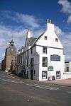 | |||
| Moray House 10 High Street | 56°15′37″N 2°37′36″W | Category C(S) | 23292 | | |||
| 48 And 52 High Street | 56°15′34″N 2°37′39″W | Category B | 23301 | | |||
| 56 And 58 High Street | 56°15′33″N 2°37′40″W | Category B | 23303 | | |||
| 17 And 19 High Street | 56°15′37″N 2°37′39″W | Category B | 23310 | | |||
| 43 & 45 High Street | 56°15′34″N 2°37′42″W | Category C(S) | 23316 | | |||
| 51 & 53 High Street | 56°15′34″N 2°37′42″W | Category C(S) | 23318 | | |||
| 63 High Street | 56°15′33″N 2°37′43″W | Category C(S) | 23322 | | |||
| 5 West Green | 56°15′35″N 2°37′43″W | Category C(S) | 23329 | | |||
| 20 West Green Including Outbuilding | 56°15′32″N 2°37′45″W | Category B | 23340 | | |||
| 22 West Green | 56°15′31″N 2°37′45″W | Category C(S) | 23342 | | |||
| 1 Westgate | 56°15′32″N 2°37′43″W | Category C(S) | 23346 | | |||
| 9 Westgate | 56°15′30″N 2°37′45″W | Category B | 23349 | | |||
| 5 Shoregate | 56°15′31″N 2°37′41″W | Category B | 23363 | | |||
| 7, 7A And 7B Shoregate | 56°15′31″N 2°37′41″W | Category C(S) | 23364 | | |||
| 19 Shoregate | 56°15′29″N 2°37′39″W | Category B | 23369 | | |||
| 33 Shoregate | 56°15′28″N 2°37′41″W | Category C(S) | 23377 | | |||
| 39 Shoregate | 56°15′28″N 2°37′42″W | Category B | 23380 | | |||
| 22 Shoregate | 56°15′29″N 2°37′37″W | Category B | 23389 | | |||
| 30 And 32 Shoregate | 56°15′28″N 2°37′38″W | Category C(S) | 23393 | | |||
| 1, 2, 3 And 4 Castle Terrace Including Retaining Wall | 56°15′30″N 2°37′38″W | Category B | 23399 | | |||
| 25 Castle Street And 12 Shoregate | 56°15′31″N 2°37′39″W | Category B | 23406 | | |||
| 10 Castle Street | 56°15′35″N 2°37′36″W | Category B | 23409 | | |||
| 26 Castle Street | 56°15′33″N 2°37′36″W | Category C(S) | 23415 | | |||
| 28 Castle Street | 56°15′33″N 2°37′36″W | Category B | 23416 | | |||
| Rumford, Garden Walls And Garage | 56°15′33″N 2°37′32″W | Category C(S) | 23421 | | |||
| 5 And 6 Rumford | 56°15′34″N 2°37′33″W | Category B | 23422 | | |||
| Parish Churchyard Walls And Gravestones | 56°15′46″N 2°37′31″W | Category A | 23245 | | |||
| Bluestane House 5 Marketgate Including Garden Wall S Outbuildings And 'Blue Stane' | 56°15′44″N 2°37′30″W | Category B | 23249 | | |||
| Sundial Within Garden Of 5 Marketgate | 56°15′44″N 2°37′36″W | Category B | 23250 | | |||
| Friar's Court 9 Marketgate (Including Garden Wall S) | 56°15′42″N 2°37′32″W | Category A | 23253 | 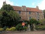 | |||
| 11 Marketgate | 56°15′42″N 2°37′33″W | Category B | 23254 | | |||
| 21 Marketgate | 56°15′40″N 2°37′35″W | Category B | 23258 | | |||
| 12 Marketgate | 56°15′43″N 2°37′28″W | Category C(S) | 23266 | | |||
| 16 And 18 Marketgate | 56°15′42″N 2°37′29″W | Category C(S) | 23268 | | |||
| 22 Marketgate | 56°15′41″N 2°37′29″W | Category B | 23270 | | |||
| 34 Marketgate | 56°15′41″N 2°37′30″W | Category C(S) | 23274 | | |||
| Crail Airfield, Technical Area, Fire Station, No 62298 09198 | 56°16′26″N 2°36′37″W | Category C(S) | 50558 | | |||
| Crail Airfield, Technical Area, Main Office, No 62371 09170 | 56°16′25″N 2°36′33″W | Category B | 50564 | | |||
| 9 Nethergate | 56°15′41″N 2°37′23″W | Category C(S) | 23426 | | |||
| 64 Nethergate | 56°15′33″N 2°37′30″W | Category C(S) | 23464 | | |||
| 70 And 72 Nethergate | 56°15′34″N 2°37′32″W | Category C(S) | 23467 | | |||
| Library (Former Burgh School) Nethergate | 56°15′35″N 2°37′30″W | Category B | 23470 | | |||
| 8 And 10 Tolbooth Wynd Including Garden Wall To Tolbooth Wynd | 56°15′37″N 2°37′28″W | Category B | 23475 | | |||
| 11 St Andrew's Road | 56°15′40″N 2°37′38″W | Category C(S) | 23477 | | |||
| The Tolbooth And Town Hall, Marketgate | 56°15′39″N 2°37′34″W | Category A | 23287 | | |||
| 2 High Street And Corner Of Tolbooth Wynd | 56°15′38″N 2°37′35″W | Category C(S) | 23289 | | |||
| 16 High Street And 2 Castle Street | 56°15′37″N 2°37′36″W | Category B | 23293 | | |||
| 42 And 44 High Street | 56°15′34″N 2°37′39″W | Category C(S) | 23299 | | |||
| 5 And 7 High Street | 56°15′38″N 2°37′38″W | Category C(S) | 23308 | | |||
| 16 West Green | 56°15′33″N 2°37′45″W | Category C(S) | 23336 | | |||
| 19 West Green | 56°15′32″N 2°37′45″W | Category C(S) | 23339 | | |||
| 16 And 18 Westgate | 56°15′29″N 2°37′45″W | Category B | 23353 | | |||
| 1 West Lane And 1 Shoregate | 56°15′31″N 2°37′42″W | Category B | 23358 | | |||
| 9 And 11 Shoregate | 56°15′30″N 2°37′40″W | Category B | 23365 | | |||
| 13 Shoregate | 56°15′30″N 2°37′40″W | Category B | 23366 | | |||
| 21 Shoregate | 56°15′29″N 2°37′38″W | Category B | 23370 | | |||
| 25 Shoregate | 56°15′29″N 2°37′39″W | Category C(S) | 23373 | | |||
| 34-45 Shoregate, Retaining Walls | 56°15′28″N 2°37′44″W | Category B | 23384 | | |||
| 10 Shoregate | 56°15′31″N 2°37′40″W | Category B | 23387 | | |||
| 38 Shoregate Harbour Office | 56°15′28″N 2°37′39″W | Category B | 23397 | | |||
| 17 Castle Street | 56°15′32″N 2°37′37″W | Category C(S) | 23404 | | |||
| 2 Rose Wynd Bruce Cottage | 56°15′35″N 2°37′36″W | Category C(S) | 23419 | | |||
| Kirkmay House Hotel 7 Marketgate | 56°15′43″N 2°37′33″W | Category A | 23251 | 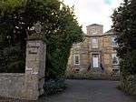 | |||
| 17 Marketgate | 56°15′41″N 2°37′34″W | Category C(S) | 23256 | | |||
| 25 27, 29 Marketgate | 56°15′40″N 2°37′35″W | Category C(S) | 23260 | | |||
| 30 And 32 Marketgate | 56°15′41″N 2°37′30″W | Category B | 23273 | | |||
| 36 Marketgate | 56°15′41″N 2°37′30″W | Category B | 23275 | | |||
| Kingsmuir Farm, House | 56°15′58″N 2°45′02″W | Category B | 4334 | | |||
| Cambo, Gamekeepers Lodge | 56°17′08″N 2°38′58″W | Category B | 51 | | |||
| Crail Airfield, Technical Area, Aircraft Painting Hangar, No 62422 09300 | 56°16′29″N 2°36′30″W | Category B | 50548 | | |||
| Crail Airfield, Technical Area, Electrical Substation A, No 62300 09176 | 56°16′25″N 2°36′37″W | Category C(S) | 50556 | | |||
| Crail Airfield, Technical Area, Pump Houses, No 62258 09147 And No62270 09142 | 56°16′24″N 2°36′40″W | Category C(S) | 50569 | | |||
| Crail Airfield, Technical Area, Torpedo Workshop, No 62435 09259 | 56°16′28″N 2°36′30″W | Category B | 50574 | | |||
| Crail Airfield, West Camp, Church, No 62140 09275 | 56°16′28″N 2°36′47″W | Category C(S) | 50575 | | |||
| Crail Airfield, West Camp, Junior Officers Quarters, No 61933 09234 | 56°16′27″N 2°36′59″W | Category C(S) | 50577 | | |||
| 10 Rumford | 56°15′33″N 2°37′35″W | Category B | 23425 | | |||
| 23 Nethergate | 56°15′39″N 2°37′24″W | Category C(S) | 23431 | | |||
| 67 Nethergate | 56°15′34″N 2°37′33″W | Category C(S) | 23441 | | |||
| 30 Nethergate | 56°15′37″N 2°37′25″W | Category C(S) | 23452 | | |||
| Crail Church Hall, St Andrew's Road Including Front Wall, Railings And Wrought-Iron Lampholders | 56°15′43″N 2°37′46″W | Category B | 23478 | | |||
| 56 Marketgate | 56°15′39″N 2°37′33″W | Category C(S) | 23282 | | |||
| 26 High Street | 56°15′36″N 2°37′38″W | Category C(S) | 23294 | | |||
| Former Maltings Building At Rear Of 56-60 High St Reet | 56°15′32″N 2°37′41″W | Category C(S) | 23305 | | |||
| 27 & 29 High Street | 56°15′36″N 2°37′40″W | Category C(S) | 23314 | | |||
| 47 & 49 High Street | 56°15′34″N 2°37′41″W | Category C(S) | 23317 | | |||
| 21 West Green Including Front Area Wall And Outbuilding | 56°15′31″N 2°37′46″W | Category C(S) | 23341 | | |||
| 6 Westgate | 56°15′30″N 2°37′43″W | Category B | 23351 | | |||
| Longskerrys, West Braes | 56°15′24″N 2°37′50″W | Category B | 23357 | | |||
| 2 Shoregate, Burgess House Including Garden Wall To Shoregate And St Clair's Wynd | 56°15′32″N 2°37′41″W | Category C(S) | 23385 | | |||
| 20 Shoregate | 56°15′30″N 2°37′36″W | Category B | 23388 | | |||
| Crail Castle Wall With Stabling And Coachhouses | 56°15′31″N 2°37′38″W | Category B | 23400 | | |||
| 8 Castle Street | 56°15′36″N 2°37′36″W | Category B | 23408 | | |||
| 12 Castle Street | 56°15′35″N 2°37′37″W | Category B | 23410 | | |||
| 20 And 22 Castle Street | 56°15′34″N 2°37′36″W | Category C(S) | 23413 | | |||
| 1 And 2 Rumford Including Garden Walls And Outbuildings | 56°15′32″N 2°37′33″W | Category B | 23420 | | |||
| Crail Parish Church | 56°15′46″N 2°37′33″W | Category A | 23244 | 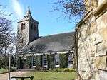 | |||
| Denburn House 1 Marketgate Including Outbuildings And Garden Walls | 56°15′45″N 2°37′28″W | Category B | 23247 | | |||
| 13-15 Marketgate | 56°15′41″N 2°37′33″W | Category C(S) | 23255 | | |||
| 23 Marketgate | 56°15′40″N 2°37′35″W | Category C(S) | 23259 | | |||
| 24 Marketgate | 56°15′41″N 2°37′29″W | Category B | 23271 | | |||
| Balcomie Castle, Walled Garden | 56°16′46″N 2°36′21″W | Category B | 4328 | | |||
| Crail Airfield, Technical Area, Air Ministry Laboratory Trainer Building, No 62357 09269 | 56°16′28″N 2°36′34″W | Category A | 50549 | | |||
| Crail Airfield, Technical Area, Decontamination Station, No 62354 09138 | 56°16′24″N 2°36′34″W | Category C(S) | 50553 | | |||
| Crail Airfield, Technical Area, Photographic Building, No 62531 09021 | 56°16′20″N 2°36′24″W | Category B | 50568 | | |||
| 57 And 59 Nethergate | 56°15′35″N 2°37′31″W | Category C(S) | 23438 | | |||
| 32 Nethergate | 56°15′37″N 2°37′25″W | Category C(S) | 23453 | | |||
| 40 And 42 Nethergate | 56°15′36″N 2°37′27″W | Category C(S) | 23456 | | |||
| 60 Nethergate | 56°15′33″N 2°37′29″W | Category C(S) | 23462 | | |||
| 68 Nethergate Including Garden Walls And Outbuildings | 56°15′33″N 2°37′31″W | Category B | 23466 | | |||
| 46 High Street | 56°15′34″N 2°37′39″W | Category B | 23300 | | |||
| 55 & 57 High Street | 56°15′33″N 2°37′42″W | Category B | 23319 | | |||
| 13 West Green, Town Council Store And Garage | 56°15′34″N 2°37′44″W | Category C(S) | 23334 | | |||
| 14 & 15 West Green | 56°15′33″N 2°37′44″W | Category C(S) | 23335 | | |||
| 23 West Green | 56°15′31″N 2°37′45″W | Category C(S) | 23343 | | |||
| 7 Westgate | 56°15′31″N 2°37′44″W | Category B | 23348 | | |||
| 3 Shoregate | 56°15′31″N 2°37′42″W | Category B | 23362 | | |||
| 37 Shoregate Including Area Walls | 56°15′28″N 2°37′41″W | Category B | 23379 | | |||
| 24 Shoregate | 56°15′29″N 2°37′37″W | Category B | 23390 | | |||
| 34 Shoregate | 56°15′28″N 2°37′39″W | Category B | 23395 | | |||
| Crail Castle | 56°15′30″N 2°37′33″W | Category B | 23401 | | |||
| 1 Rose Wynd | 56°15′35″N 2°37′36″W | Category B | 23418 | | |||
| 7 Rumford | 56°15′33″N 2°37′34″W | Category B | 23423 | | |||
| Kirkmay House Hotel Entrance Gates And Garden Wall S Marketgate | 56°15′43″N 2°37′31″W | Category B | 23252 | | |||
| 2 Marketgate | 56°15′44″N 2°37′27″W | Category B | 23262 | | |||
| 4 Marketgate | 56°15′44″N 2°37′27″W | Category B | 23263 | | |||
| 26 And 28 Marketgate | 56°15′41″N 2°37′30″W | Category B | 23272 | | |||
| 46 Marketgate | 56°15′40″N 2°37′31″W | Category C(S) | 23278 | | |||
| Airdrie Lodge, Gatepiers | 56°15′19″N 2°42′03″W | Category B | 4333 | | |||
| Crail Airfield, Technical Area, Armoury, No 62535 09242 | 56°16′27″N 2°36′24″W | Category B | 50550 | | |||
| Crail Airfield, Technical Area, Generating Station, No 62402 09329 | 56°16′30″N 2°36′31″W | Category C(S) | 50560 | | |||
| Crail Airfield, West Camp, Gymnasium And Cinema, No 62168 09290 | 56°16′28″N 2°36′45″W | Category B | 50576 | | |||
| 25 And 27 Nethergate | 56°15′39″N 2°37′25″W | Category C(S) | 23432 | | |||
| 63 Nethergate | 56°15′35″N 2°37′32″W | Category C(S) | 23440 | | |||
| 14 Nethergate | 56°15′39″N 2°37′22″W | Category C(S) | 23449 | | |||
| 2 Kirk Wynd | 56°15′45″N 2°37′26″W | Category C(S) | 23473 | | |||
| 5, 7, 8 And 9 St Andrew's Road | 56°15′40″N 2°37′37″W | Category C(S) | 23476 | | |||
| 52, 54 Marketgate | 56°15′39″N 2°37′32″W | Category C(S) | 23281 | | |||
| 3 High Street | 56°15′38″N 2°37′37″W | Category B | 23307 | | |||
| East Neuk Hotel, High Street | 56°15′32″N 2°37′44″W | Category C(S) | 23324 | | |||
| 3 West Green | 56°15′35″N 2°37′41″W | Category C(S) | 23327 | | |||
| 18 West Green | 56°15′32″N 2°37′45″W | Category C(S) | 23338 | | |||
| 25 And 26 West Green | 56°15′30″N 2°37′45″W | Category C(S) | 23345 | | |||
| David Mayes' Garages 11 Westgate | 56°15′30″N 2°37′45″W | Category C(S) | 23350 | | |||
| 14 Westgate | 56°15′29″N 2°37′45″W | Category B | 23352 | | |||
| 23 Shoregate | 56°15′29″N 2°37′38″W | Category C(S) | 23371 | | |||
| Retaining Walls Fronting 15 To 23 Shoregate | 56°15′29″N 2°37′38″W | Category B | 23372 | | |||
| 27 Shoregate | 56°15′28″N 2°37′39″W | Category C(S) | 23374 | | |||
| 45 Shoregate | 56°15′28″N 2°37′43″W | Category B | 23383 | | |||
| 26 Shoregate | 56°15′29″N 2°37′38″W | Category B | 23391 | | |||
| Sundial, Castle Promenade | 56°15′29″N 2°37′34″W | Category B | 23402 | | |||
| 1 Castle Street (And 22 High Street Including Wall To Castle Street) | 56°15′36″N 2°37′37″W | Category B | 23403 | | |||
| 17-25 Castle Street And 12 Shoregate, Retaining Walls | 56°15′30″N 2°37′39″W | Category C(S) | 23407 | | |||
| 16 And 18 Castle Street | 56°15′34″N 2°37′36″W | Category C(S) | 23412 | | |||
| 19 Marketgate Archway To The Close | 56°15′41″N 2°37′34″W | Category C(S) | 23257 | | |||
| 6 And 8 Marketgate | 56°15′43″N 2°37′28″W | Category B | 23264 | | |||
| 10 Marketgate | 56°15′43″N 2°37′28″W | Category C(S) | 23265 | | |||
| Balcomie Castle, Including Farmhouse And Steading | 56°16′47″N 2°36′27″W | Category B | 4327 | | |||
| West Newhall Farmhouse | 56°16′52″N 2°39′02″W | Category B | 4331 | | |||
| Crail Airfield, Technical Area, Control Tower, No 62565 09048 | 56°16′21″N 2°36′22″W | Category A | 50552 | | |||
| Crail Airfield, Technical Area, Latrine Block, No 62553 09398 | 56°16′32″N 2°36′23″W | Category C(S) | 50563 | | |||
| Crail Airfield, Technical Area, Sick Bay, No 62314 09121 | 56°16′23″N 2°36′36″W | Category B | 50571 | | |||
| Crail Airfield, Technical Area, Squadron Office, No 62383 09131 | 56°16′23″N 2°36′32″W | Category B | 50572 | | |||
| Crail Airfield, Technical Area, Torpedo Attack Training Building, No 62451 09377 | 56°16′31″N 2°36′29″W | Category A | 50573 | | |||
| 13 Nethergate | 56°15′41″N 2°37′23″W | Category C(S) | 23428 | | |||
| 19 Nethergate | 56°15′40″N 2°37′24″W | Category C(S) | 23429 | | |||
| 29 Nethergate | 56°15′39″N 2°37′25″W | Category C(S) | 23433 | | |||
| 61 Nethergate | 56°15′35″N 2°37′32″W | Category C(S) | 23439 | | |||
| 38 Nethergate | 56°15′36″N 2°37′26″W | Category B | 23455 | | |||
| 54 Nethergate, Marine Hotel | 56°15′34″N 2°37′28″W | Category C(S) | 23460 | | |||
| 76 Nethergate | 56°15′34″N 2°37′31″W | Category C(S) | 23469 | | |||
| St Christopher's Kirk Wynd | 56°15′44″N 2°37′27″W | Category C(S) | 23472 | | |||
| 60 Marketgate, Balfour House Including Garden Wall To Tolbooth Wynd | 56°15′38″N 2°37′34″W | Category B | 23284 | | |||
| Cowan House 8 High Street | 56°15′37″N 2°37′36″W | Category C(S) | 23291 | | |||
| 34 And 36 High Street | 56°15′35″N 2°37′38″W | Category C(S) | 23297 | | |||
| 38 And 40 High Street | 56°15′34″N 2°37′38″W | Category C(S) | 23298 | | |||
| 59 High Street | 56°15′33″N 2°37′42″W | Category C(S) | 23320 | | |||
| 1 West Green Including Front Area Wall | 56°15′35″N 2°37′41″W | Category C(S) | 23325 | | |||
| Bakery And Store (R Fisher) West Green | 56°15′34″N 2°37′42″W | Category C(S) | 23333 | | |||
| 3, 5 Westgate, Airds Court Including Courtyard Wall And Gatepiers | 56°15′31″N 2°37′44″W | Category C(S) | 23347 | | |||
| 20 Westgate | 56°15′29″N 2°37′46″W | Category C(S) | 23354 | | |||
| 22 And 24 Westgate | 56°15′29″N 2°37′44″W | Category B | 23355 | | |||
| 4, 5 West Lane | 56°15′31″N 2°37′42″W | Category C(S) | 23360 | | |||
| 41 Shoregate | 56°15′28″N 2°37′42″W | Category C(S) | 23381 | | |||
| 43 Shoregate | 56°15′28″N 2°37′43″W | Category C(S) | 23382 | | |||
| Public Convenience, Shoregate | 56°15′28″N 2°37′38″W | Category C(S) | 23394 | | |||
| 23 Castle Street | 56°15′32″N 2°37′39″W | Category C(S) | 23405 | | |||
| 14 Castle Street Including Back Building Used By Occupants Of No 12 | 56°15′35″N 2°37′36″W | Category C(S) | 23411 | | |||
| 14 Marketgate | 56°15′42″N 2°37′28″W | Category C(S) | 23267 | | |||
| 48 Marketgate | 56°15′40″N 2°37′32″W | Category C(S) | 23279 | | |||
| Wormiston, Doocot | 56°16′38″N 2°37′53″W | Category A | 4329 | 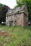 | |||
| Crail Airfield, Technical Area, Army Personnel Building, No 62499 09391 | 56°16′32″N 2°36′26″W | Category C(S) | 50551 | | |||
| Crail Airfield, Technical Area, Engine And Aircraft Repair Shop, No 62507 09328 | 56°16′30″N 2°36′25″W | Category A | 50557 | | |||
| Crail Airfield, Technical Area, Flame Store, No 62357 09112 | 56°16′23″N 2°36′34″W | Category C(S) | 50559 | | |||
| Crail Airfield, Technical Area, Guard House, No 62323 09233 | 56°16′27″N 2°36′36″W | Category B | 50561 | | |||
| Crail Airfield, Technical Area, Passive Defence Shelters, No 62350 09284 And No 62366 09311 | 56°16′28″N 2°36′34″W | Category C(S) | 50567 | | |||
| Crail Airfield, Technical Area, Sea Markers Store, No 62286 09165 | 56°16′24″N 2°36′38″W | Category C(S) | 50570 | | |||
| Crail Airfield, West Camp, Junior Rates Block No 61747 09190 | 56°16′25″N 2°37′09″W | Category C(S) | 50578 | | |||
| 31 Nethergate | 56°15′38″N 2°37′26″W | Category C(S) | 23434 | | |||
| 47 Nethergate | 56°15′36″N 2°37′29″W | Category C(S) | 23436 | | |||
| 69 Nethergate, Maldon | 56°15′34″N 2°37′33″W | Category C(S) | 23442 | | |||
| 16 Nethergate | 56°15′39″N 2°37′23″W | Category B | 23450 | | |||
| 48 Nethergate | 56°15′35″N 2°37′28″W | Category C(S) | 23458 | | |||
| 50 And 52 Nethergate | 56°15′35″N 2°37′28″W | Category B | 23459 | | |||
| 56 And 58 Nethergate | 56°15′34″N 2°37′29″W | Category C(S) | 23461 | | |||
| 62 Nethergate | 56°15′33″N 2°37′30″W | Category C(S) | 23463 | | |||
| 7 Tolbooth Street, Selcraig,Including Boundary Walls | 56°15′37″N 2°37′31″W | Category C(S) | 23474 | | |||
| 50 Marketgate | 56°15′40″N 2°37′32″W | Category C(S) | 23280 | | |||
| 64 Marketgate | 56°15′39″N 2°37′34″W | Category B | 23286 | | |||
| 30 And 32 High Street | 56°15′35″N 2°37′38″W | Category C(S) | 23296 | | |||
| 62 High Street | 56°15′32″N 2°37′41″W | Category C(S) | 23306 | | |||
| 15 High Street | 56°15′37″N 2°37′38″W | Category C(S) | 23309 | | |||
| 31 & 33 High Street | 56°15′36″N 2°37′40″W | Category C(S) | 23315 | | |||
| 61 High Street | 56°15′33″N 2°37′43″W | Category C(S) | 23321 | | |||
| 26 Westgate, The Haven | 56°15′28″N 2°37′47″W | Category B | 23356 | | |||
| 6 West Lane | 56°15′30″N 2°37′41″W | Category B | 23361 | | |||
| 17 Shoregate | 56°15′30″N 2°37′39″W | Category B | 23368 | | |||
| 29 Shoregate | 56°15′28″N 2°37′40″W | Category C(S) | 23375 | | |||
| 35 Shoregate (The Custom House) | 56°15′28″N 2°37′41″W | Category A | 23378 | 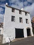 | |||
| 8 Shoregate | 56°15′31″N 2°37′40″W | Category B | 23386 | | |||
| Crail Harbour | 56°15′27″N 2°37′43″W | Category A | 23398 | 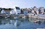 | |||
| 24 Castle Street | 56°15′33″N 2°37′36″W | Category C(S) | 23414 | | |||
| Parish Churchyard Deadhouse | 56°15′46″N 2°37′34″W | Category B | 23246 | | |||
| Wormiston, Stables | 56°16′37″N 2°37′46″W | Category B | 4330 | 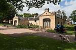 | |||
| Crail Airfield, Technical Area, Latrine Block, No 62404 09143 | 56°16′24″N 2°36′31″W | Category C(S) | 50562 | | |||
| Crail Airfield, Technical Area, Main Store Sheds, No 62587 09376 | 56°16′31″N 2°36′21″W | Category B | 50565 | | |||
| 11 Nethergate | 56°15′41″N 2°37′23″W | Category C(S) | 23427 | | |||
| 43 Nethergate | 56°15′37″N 2°37′27″W | Category B | 23435 | | |||
| Priory Doocot, Off Nethergate | 56°15′41″N 2°37′18″W | Category A | 23445 | 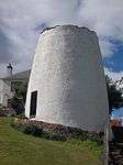 | |||
| Garage And Garden Wall To Doocot Park, Nethergate | 56°15′41″N 2°37′21″W | Category B | 23446 | | |||
| 36 Nethergate | 56°15′36″N 2°37′26″W | Category B | 23454 | | |||
| 66 Nethergate | 56°15′33″N 2°37′31″W | Category B | 23465 | | |||
| 58 Marketgate | 56°15′39″N 2°37′33″W | Category C(S) | 23283 | | |||
| 62 Marketgate | 56°15′39″N 2°37′34″W | Category C(S) | 23285 | | |||
| The Beehive 28 High Street | 56°15′35″N 2°37′38″W | Category C(S) | 23295 | | |||
| 54 High Street | 56°15′33″N 2°37′40″W | Category B | 23302 | | |||
| 60 High Street | 56°15′32″N 2°37′41″W | Category B | 23304 | | |||
| 21 High Street | 56°15′36″N 2°37′39″W | Category C(S) | 23311 | | |||
| 23 High Street | 56°15′36″N 2°37′39″W | Category C(S) | 23312 | | |||
| 25 High Street | 56°15′36″N 2°37′39″W | Category C(S) | 23313 | | |||
| 65 High Street | 56°15′33″N 2°37′43″W | Category C(S) | 23323 | | |||
| 2 West Green Including Front Area Wall | 56°15′35″N 2°37′41″W | Category C(S) | 23326 | | |||
| 4 West Green | 56°15′35″N 2°37′42″W | Category C(S) | 23328 | | |||
| 9-10 West Green | 56°15′34″N 2°37′43″W | Category C(S) | 23330 | | |||
| 11 West Green | 56°15′33″N 2°37′43″W | Category C(S) | 23331 | | |||
| Garage (R Anderson) West Green | 56°15′34″N 2°37′42″W | Category C(S) | 23332 | | |||
| 17 West Green | 56°15′33″N 2°37′45″W | Category C(S) | 23337 | | |||
| 24 West Green | 56°15′31″N 2°37′46″W | Category C(S) | 23344 | | |||
| 3 West Lane | 56°15′31″N 2°37′42″W | Category C(S) | 23359 | | |||
| 15 Shoregate | 56°15′30″N 2°37′39″W | Category B | 23367 | | |||
| 31 Shoregate | 56°15′28″N 2°37′40″W | Category C(S) | 23376 | | |||
| 28 Shoregate | 56°15′28″N 2°37′38″W | Category B | 23392 | | |||
| 36 Shoregate | 56°15′28″N 2°37′39″W | Category B | 23396 | | |||
| 31 Castle Street | 56°15′32″N 2°37′35″W | Category B | 23417 | | |||
| The Old Manse 3 Marketgate Including Garden Walls And Outbuildings | 56°15′45″N 2°37′28″W | Category B | 23248 | | |||
| Royal Bank Of Scotland Marketgate And St Andrew's Road | 56°15′39″N 2°37′36″W | Category C(S) | 23261 | | |||
| 20 Marketgate, Garwyn | 56°15′42″N 2°37′29″W | Category C(S) | 23269 | | |||
| 38 And 40 Marketgate | 56°15′40″N 2°37′31″W | Category B | 23276 | | |||
| 42 And 44 Marketgate | 56°15′40″N 2°37′31″W | Category B | 23277 | | |||
| Airdrie House | 56°16′00″N 2°42′05″W | Category B | 4332 | | |||
| Wormiston House | 56°16′38″N 2°37′49″W | Category B | 50 | 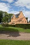 | |||
| Crail Airfield, Technical Area, Disinfector House, No 62310 09088 | 56°16′22″N 2°36′37″W | Category C(S) | 50554 | | |||
| Crail Airfield, Technical Area, Dispersal Area Office, No 62343 09101 | 56°16′22″N 2°36′35″W | Category C(S) | 50555 | | |||
| Crail Airfield, Technical Area, Mortuary, No 62286 09091 | 56°16′22″N 2°36′38″W | Category C(S) | 50566 | |
Key
The scheme for classifying buildings in Scotland is:
- Category A: "buildings of national or international importance, either architectural or historic; or fine, little-altered examples of some particular period, style or building type."[1]
- Category B: "buildings of regional or more than local importance; or major examples of some particular period, style or building type, which may have been altered."[1]
- Category C: "buildings of local importance; lesser examples of any period, style, or building type, as originally constructed or moderately altered; and simple traditional buildings which group well with other listed buildings."[1]
In March 2016 there were 47,288 listed buildings in Scotland. Of these, 8% were Category A, and 50% were Category B, with the remaining 42% being Category C.[2]
gollark: Idea: make identifiers be considered identical if the first 8 chars match.
gollark: <@319753218592866315> Idea: macron keywords are just camelcase sentences.
gollark: I mean, no physical limit.
gollark: There's no actual *data* limit, only bitrate ones! UTTER BEES!
gollark: Anyway, I pay £9 a month for this 8GB of data, which is very bees and irritating.
See also
Notes
- Sometimes known as OSGB36, the grid reference (where provided) is based on the British national grid reference system used by the Ordnance Survey.
• "Guide to National Grid". Ordnance Survey. Retrieved 12 December 2007.
• "Get-a-map". Ordnance Survey. Retrieved 17 December 2007. - Historic Environment Scotland assign a unique alphanumeric identifier to each designated site in Scotland, for listed buildings this always begins with "LB", for example "LB12345".
References
- All entries, addresses and coordinates are based on data from Historic Scotland. This data falls under the Open Government Licence
- "What is Listing?". Historic Environment Scotland. Retrieved 29 May 2018.
- Scotland's Historic Environment Audit 2016 (PDF). Historic Environment Scotland and the Built Environment Forum Scotland. pp. 15–16. Retrieved 29 May 2018.
This article is issued from Wikipedia. The text is licensed under Creative Commons - Attribution - Sharealike. Additional terms may apply for the media files.