List of listed buildings in Craig, Angus
List
| Name | Location | Date Listed | Grid Ref. [note 1] | Geo-coordinates | Notes | LB Number [note 2] | Image |
|---|---|---|---|---|---|---|---|
| Fishtown Of Usan, Lookout Tower (2 Of 2) | 56°40′55″N 2°27′11″W | Category C(S) | 43894 |  | |||
| Inchbrayock House | 56°41′47″N 2°27′43″W | Category B | 4956 | | |||
| Scotston Of Usan Farmhouse | 56°41′05″N 2°28′00″W | Category C(S) | 4968 | | |||
| Dunninald Castle | 56°40′45″N 2°29′08″W | Category A | 4972 | | |||
| Dunninald Mains Steading | 56°40′45″N 2°28′53″W | Category B | 4977 | | |||
| Craig House - Stables | 56°41′49″N 2°29′10″W | Category B | 4986 | | |||
| Craig House - Walled Gardens | 56°41′50″N 2°29′13″W | Category B | 4987 | | |||
| 7 Fishtown Of Usan, Former Farmhouse | 56°40′57″N 2°27′09″W | Category C(S) | 43895 | | |||
| Dunninald Mains Farmhouse | 56°40′45″N 2°28′55″W | Category B | 4976 | | |||
| Parish Kirk - Entrance Gates | 56°41′33″N 2°29′08″W | Category B | 4980 | | |||
| Parish Kirk - Mausoleum | 56°41′35″N 2°29′08″W | Category B | 4981 | | |||
| Ferryden Church (Of Scotland) | 56°42′02″N 2°28′04″W | Category B | 92 | 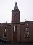 | |||
| 8-21 (Inclusive Nos) Fishtown Of Usan With Lookout Tower (1 Of 2) | 56°40′56″N 2°27′07″W | Category C(S) | 4963 | 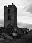 | |||
| Dunninald - Old Gatepiers | 56°40′35″N 2°29′00″W | Category B | 4973 | | |||
| Dunninald - North Lodge And Gates | 56°41′00″N 2°29′14″W | Category B | 4974 | 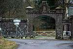 | |||
| Craig House | 56°41′49″N 2°29′13″W | Category A | 4984 | | |||
| Craigview House | 56°41′37″N 2°29′03″W | Category B | 4957 | | |||
| Scurdie Ness Lighthouse (Montroseness Lighthouse) | 56°42′06″N 2°26′14″W | Category B | 4958 | 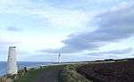 | |||
| Beacon, Scurdie Ness | 56°42′07″N 2°26′46″W | Category B | 4959 | | |||
| Usan House - Lodge | 56°41′20″N 2°27′18″W | Category B | 4966 | | |||
| Usan House - Entrance Gates | 56°41′20″N 2°27′18″W | Category B | 4967 | | |||
| Chapel Of St. Skae | 56°40′35″N 2°27′59″W | Category B | 4969 | | |||
| Chapel Of St. Skae - Retaining Wall | 56°40′36″N 2°28′00″W | Category B | 4970 | | |||
| Parish Kirk Manse | 56°41′37″N 2°29′03″W | Category B | 4982 | | |||
| Craig Schoolhouse | 56°41′33″N 2°29′05″W | Category B | 4983 | | |||
| Fishtown Of Usan, Pair Of Cottages | 56°40′57″N 2°27′13″W | Category C(S) | 43897 | | |||
| Ferryden Tower And Steeple Of Old Infants School, Rossie Terrace | 56°42′04″N 2°27′41″W | Category C(S) | 5118 | | |||
| Fishtown Of Usan, Old Icehouse | 56°40′56″N 2°26′56″W | Category C(S) | 4962 | | |||
| Dunninald - Stables | 56°40′44″N 2°28′59″W | Category B | 4975 | | |||
| Balgove Farmhouse | 56°41′42″N 2°29′28″W | Category B | 4989 | | |||
| Usan House | 56°41′17″N 2°27′19″W | Category A | 4964 | 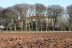 | |||
| Craig House - South Entrance Gatepiers | 56°41′44″N 2°29′05″W | Category B | 4988 | | |||
| 24 Fishtown Of Usan | 56°40′57″N 2°26′59″W | Category C(S) | 4961 | | |||
| Usan House - Stables | 56°41′19″N 2°27′16″W | Category B | 4965 | | |||
| East Mains Of Dysart Farmhouse | 56°41′01″N 2°30′07″W | Category B | 4978 | | |||
| Fishtown Of Usan, Coastguard Station, Life-Saving Apparatus House | 56°40′55″N 2°27′08″W | Category C(S) | 43896 | | |||
| Chapel Mill - Burial Ground | 56°41′32″N 2°26′35″W | Category B | 4960 | 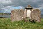 | |||
| Old Limekilns, Boddin Point | 56°40′16″N 2°28′09″W | Category B | 4971 | 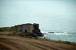 | |||
| Kirkton Of Craig, Kirk Tower House | 56°41′34″N 2°29′07″W | Category A | 4979 | .jpg) | |||
| Craig House - Entrance Gateway | 56°41′48″N 2°29′10″W | Category A | 4985 | |
Key
The scheme for classifying buildings in Scotland is:
- Category A: "buildings of national or international importance, either architectural or historic; or fine, little-altered examples of some particular period, style or building type."[1]
- Category B: "buildings of regional or more than local importance; or major examples of some particular period, style or building type, which may have been altered."[1]
- Category C: "buildings of local importance; lesser examples of any period, style, or building type, as originally constructed or moderately altered; and simple traditional buildings which group well with other listed buildings."[1]
In March 2016 there were 47,288 listed buildings in Scotland. Of these, 8% were Category A, and 50% were Category B, with the remaining 42% being Category C.[2]
gollark: <:chips:453465151132139521> <:chips:453465151132139521> <:chips:453465151132139521> <:chips:453465151132139521> <:chips:453465151132139521> <:chips:453465151132139521> <:chips:453465151132139521> <:chips:453465151132139521> <:chips:453465151132139521> <:chips:453465151132139521> <:chips:453465151132139521> <:chips:453465151132139521> <:chips:453465151132139521> <:chips:453465151132139521> <:chips:453465151132139521> <:chips:453465151132139521> <:chips:453465151132139521> <:chips:453465151132139521> <:chips:453465151132139521> <:chips:453465151132139521> <:chips:453465151132139521> <:chips:453465151132139521> <:chips:453465151132139521> <:chips:453465151132139521> <:chips:453465151132139521> <:chips:453465151132139521> <:chips:453465151132139521> <:chips:453465151132139521> <:chips:453465151132139521> <:chips:453465151132139521> <:chips:453465151132139521> <:chips:453465151132139521> <:chips:453465151132139521> <:chips:453465151132139521> <:chips:453465151132139521> <:chips:453465151132139521> <:chips:453465151132139521> <:chips:453465151132139521> <:chips:453465151132139521> <:chips:453465151132139521> <:chips:453465151132139521> <:chips:453465151132139521> <:chips:453465151132139521> <:chips:453465151132139521> <:chips:453465151132139521> <:chips:453465151132139521> <:chips:453465151132139521> <:chips:453465151132139521> <:chips:453465151132139521> <:chips:453465151132139521> <:chips:453465151132139521> <:chips:453465151132139521> <:chips:453465151132139521> <:chips:453465151132139521> <:chips:453465151132139521> <:chips:453465151132139521> <:chips:453465151132139521> <:chips:453465151132139521>
gollark: <:chips:453465151132139521> <:chips:453465151132139521> <:chips:453465151132139521> <:chips:453465151132139521> <:chips:453465151132139521> <:chips:453465151132139521> <:chips:453465151132139521> <:chips:453465151132139521> <:chips:453465151132139521> <:chips:453465151132139521> <:chips:453465151132139521> <:chips:453465151132139521> <:chips:453465151132139521> <:chips:453465151132139521> <:chips:453465151132139521> <:chips:453465151132139521> <:chips:453465151132139521> <:chips:453465151132139521> <:chips:453465151132139521> <:chips:453465151132139521> <:chips:453465151132139521> <:chips:453465151132139521> <:chips:453465151132139521> <:chips:453465151132139521> <:chips:453465151132139521> <:chips:453465151132139521> <:chips:453465151132139521> <:chips:453465151132139521> <:chips:453465151132139521> <:chips:453465151132139521> <:chips:453465151132139521> <:chips:453465151132139521> <:chips:453465151132139521> <:chips:453465151132139521> <:chips:453465151132139521> <:chips:453465151132139521> <:chips:453465151132139521> <:chips:453465151132139521> <:chips:453465151132139521> <:chips:453465151132139521> <:chips:453465151132139521> <:chips:453465151132139521> <:chips:453465151132139521> <:chips:453465151132139521> <:chips:453465151132139521> <:chips:453465151132139521> <:chips:453465151132139521> <:chips:453465151132139521> <:chips:453465151132139521> <:chips:453465151132139521> <:chips:453465151132139521> <:chips:453465151132139521> <:chips:453465151132139521> <:chips:453465151132139521> <:chips:453465151132139521> <:chips:453465151132139521> <:chips:453465151132139521> <:chips:453465151132139521> ?
gollark: <:chips:453465151132139521> <:chips:453465151132139521> <:chips:453465151132139521> <:chips:453465151132139521> <:chips:453465151132139521> <:chips:453465151132139521> <:chips:453465151132139521> <:chips:453465151132139521> <:chips:453465151132139521> <:chips:453465151132139521> <:chips:453465151132139521> <:chips:453465151132139521> <:chips:453465151132139521> <:chips:453465151132139521> <:chips:453465151132139521> <:chips:453465151132139521> <:chips:453465151132139521> <:chips:453465151132139521> <:chips:453465151132139521> <:chips:453465151132139521> <:chips:453465151132139521> <:chips:453465151132139521> <:chips:453465151132139521> <:chips:453465151132139521> <:chips:453465151132139521> <:chips:453465151132139521> <:chips:453465151132139521> <:chips:453465151132139521> <:chips:453465151132139521> <:chips:453465151132139521> <:chips:453465151132139521> <:chips:453465151132139521> <:chips:453465151132139521> <:chips:453465151132139521> <:chips:453465151132139521> <:chips:453465151132139521> <:chips:453465151132139521> <:chips:453465151132139521> <:chips:453465151132139521> <:chips:453465151132139521> <:chips:453465151132139521> <:chips:453465151132139521> <:chips:453465151132139521> <:chips:453465151132139521> <:chips:453465151132139521> <:chips:453465151132139521> <:chips:453465151132139521> <:chips:453465151132139521> <:chips:453465151132139521> <:chips:453465151132139521> <:chips:453465151132139521> <:chips:453465151132139521> <:chips:453465151132139521> <:chips:453465151132139521> <:chips:453465151132139521> <:chips:453465151132139521> <:chips:453465151132139521> <:chips:453465151132139521>
gollark: <:chips:453465151132139521> <:chips:453465151132139521> <:chips:453465151132139521> <:chips:453465151132139521> <:chips:453465151132139521> <:chips:453465151132139521> <:chips:453465151132139521> <:chips:453465151132139521> <:chips:453465151132139521> <:chips:453465151132139521> <:chips:453465151132139521> <:chips:453465151132139521> <:chips:453465151132139521> <:chips:453465151132139521> <:chips:453465151132139521> <:chips:453465151132139521> <:chips:453465151132139521> <:chips:453465151132139521> <:chips:453465151132139521> <:chips:453465151132139521> <:chips:453465151132139521> <:chips:453465151132139521> <:chips:453465151132139521> <:chips:453465151132139521> <:chips:453465151132139521> <:chips:453465151132139521> <:chips:453465151132139521> <:chips:453465151132139521> <:chips:453465151132139521> <:chips:453465151132139521> <:chips:453465151132139521> <:chips:453465151132139521> <:chips:453465151132139521> <:chips:453465151132139521> <:chips:453465151132139521> <:chips:453465151132139521> <:chips:453465151132139521> <:chips:453465151132139521> <:chips:453465151132139521> <:chips:453465151132139521> <:chips:453465151132139521> <:chips:453465151132139521> <:chips:453465151132139521> <:chips:453465151132139521> <:chips:453465151132139521> <:chips:453465151132139521> <:chips:453465151132139521> <:chips:453465151132139521> <:chips:453465151132139521> <:chips:453465151132139521> <:chips:453465151132139521> <:chips:453465151132139521> <:chips:453465151132139521> <:chips:453465151132139521> <:chips:453465151132139521> <:chips:453465151132139521> <:chips:453465151132139521> <:chips:453465151132139521>
gollark: <:chips:453465151132139521> <:chips:453465151132139521> <:chips:453465151132139521> <:chips:453465151132139521> <:chips:453465151132139521> <:chips:453465151132139521> <:chips:453465151132139521> <:chips:453465151132139521> <:chips:453465151132139521> <:chips:453465151132139521> <:chips:453465151132139521> <:chips:453465151132139521> <:chips:453465151132139521> <:chips:453465151132139521> <:chips:453465151132139521> <:chips:453465151132139521> <:chips:453465151132139521> <:chips:453465151132139521> <:chips:453465151132139521> <:chips:453465151132139521> <:chips:453465151132139521> <:chips:453465151132139521> <:chips:453465151132139521> <:chips:453465151132139521> <:chips:453465151132139521> <:chips:453465151132139521> <:chips:453465151132139521> <:chips:453465151132139521> <:chips:453465151132139521> <:chips:453465151132139521> <:chips:453465151132139521> <:chips:453465151132139521> <:chips:453465151132139521> <:chips:453465151132139521> <:chips:453465151132139521> <:chips:453465151132139521> <:chips:453465151132139521> <:chips:453465151132139521> <:chips:453465151132139521> <:chips:453465151132139521> <:chips:453465151132139521> <:chips:453465151132139521> <:chips:453465151132139521> <:chips:453465151132139521> <:chips:453465151132139521> <:chips:453465151132139521> <:chips:453465151132139521> <:chips:453465151132139521> <:chips:453465151132139521> <:chips:453465151132139521> <:chips:453465151132139521> <:chips:453465151132139521> <:chips:453465151132139521> <:chips:453465151132139521> <:chips:453465151132139521> <:chips:453465151132139521> <:chips:453465151132139521> <:chips:453465151132139521>
See also
Notes
- Sometimes known as OSGB36, the grid reference (where provided) is based on the British national grid reference system used by the Ordnance Survey.
• "Guide to National Grid". Ordnance Survey. Retrieved 2007-12-12.
• "Get-a-map". Ordnance Survey. Retrieved 2007-12-17. - Historic Environment Scotland assign a unique alphanumeric identifier to each designated site in Scotland, for listed buildings this always begins with "LB", for example "LB12345".
References
- All entries, addresses and coordinates are based on data from Historic Scotland. This data falls under the Open Government Licence
- "What is Listing?". Historic Environment Scotland. Retrieved 29 May 2018.
- Scotland's Historic Environment Audit 2016 (PDF). Historic Environment Scotland and the Built Environment Forum Scotland. pp. 15–16. Retrieved 29 May 2018.
This article is issued from Wikipedia. The text is licensed under Creative Commons - Attribution - Sharealike. Additional terms may apply for the media files.