List of listed buildings in Cortachy And Clova, Angus
List
| Name | Location | Date Listed | Grid Ref. [note 1] | Geo-coordinates | Notes | LB Number [note 2] | Image |
|---|---|---|---|---|---|---|---|
| Gella Bridge Over River South Esk | 56°46′30″N 3°01′41″W | Category B | 4807 | 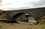 | |||
| Pitcarity Bridge Over Burn Of Inchmill | 56°46′44″N 3°06′03″W | Category B | 4814 |  | |||
| Balnaboth - Dairy-House | 56°47′20″N 3°07′25″W | Category B | 4819 | | |||
| Glen Clova, Inchdowrie House With Sunken Garden | 56°50′16″N 3°04′49″W | Category C(S) | 50702 | | |||
| Glendoll Lodge With Squash Court | 56°52′22″N 3°11′06″W | Category C(S) | 50706 | | |||
| Braeminzion Farmhouse | 56°47′22″N 3°02′24″W | Category B | 4781 | | |||
| Clova, Gallows Knowe Bridge Over River South Esk | 56°50′30″N 3°06′24″W | Category C(S) | 4791 | 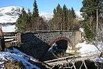 | |||
| Clova, Bridge Over Corrie Burn | 56°50′39″N 3°06′17″W | Category C(S) | 4792 | | |||
| Glenprosen Parish Kirk, Pitcarity | 56°46′42″N 3°06′03″W | Category B | 4811 | 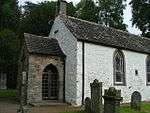 | |||
| Old Parish Kirk Manse, Pitcarity | 56°46′42″N 3°06′01″W | Category B | 4813 | | |||
| Balnaboth - Lodge | 56°46′49″N 3°06′11″W | Category B | 4823 | | |||
| Cortachy - Dairy-House | 56°43′22″N 2°58′58″W | Category B | 4833 | | |||
| Cortachy - Old Butler's House | 56°43′17″N 2°58′55″W | Category C(S) | 4835 | | |||
| Cortachy - The Red Lodge | 56°43′15″N 2°59′26″W | Category C(S) | 4799 | | |||
| Cortachy Parish Kirk Manse | 56°43′25″N 3°00′07″W | Category C(S) | 4802 | | |||
| Middlehill Cottar - House. (Owned By Middlehill Farm) | 56°45′22″N 3°00′57″W | Category C(S) | 4806 | | |||
| Lednethie Bridge Over Burn Of Lednethie | 56°45′07″N 3°04′44″W | Category C(S) | 4809 | 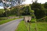 | |||
| Balnaboth House | 56°47′19″N 3°07′24″W | Category B | 4817 | | |||
| Balnaboth - Dry Bridge | 56°47′15″N 3°07′15″W | Category C(S) | 4820 | | |||
| "Lacket Cottage" Cortachy | 56°43′31″N 2°59′27″W | Category C(S) | 4829 | | |||
| Cortachy - "The Golden Gates" | 56°43′30″N 2°59′25″W | Category B | 4797 | | |||
| Cortachy - Red Lodge Gates | 56°43′14″N 2°59′27″W | Category C(S) | 4800 | | |||
| Cortachy - Gertrude Cottage | 56°43′14″N 2°59′36″W | Category C(S) | 4801 | | |||
| Muirskeith Farmhouse | 56°43′20″N 3°00′22″W | Category C(S) | 4803 | | |||
| "Burnside Cottage", Pitcarity | 56°46′43″N 3°06′05″W | Category B | 4815 | | |||
| Balnaboth - Sundial | 56°47′13″N 3°07′30″W | Category B | 4821 | | |||
| Kirkyard Walls | 56°43′30″N 2°59′20″W | Category B | 4825 | | |||
| Cortachy Village Hall, West Mill | 56°43′32″N 2°59′25″W | Category C(S) | 4828 | | |||
| Cortachy Castle | 56°43′25″N 2°59′06″W | Category B | 4831 | 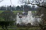 | |||
| Glen Prosen Village, K6 Telephone Kiosk | 56°46′46″N 3°06′08″W | Category B | 6470 | | |||
| Braeminzion Steading | 56°47′22″N 3°02′27″W | Category B | 4782 | | |||
| Clova, Kirkton Cottage | 56°50′39″N 3°06′22″W | Category C(S) | 4795 | | |||
| Memorial Fountain Glackburn | 56°43′58″N 3°01′44″W | Category C(S) | 4805 | | |||
| Balnaboth - Steading | 56°47′19″N 3°07′17″W | Category C(S) | 4818 | | |||
| Balnaboth - Chapel | 56°47′16″N 3°06′57″W | Category B | 4822 | 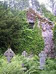 | |||
| Cortachy Bridge Over River South Esk | 56°43′33″N 2°59′22″W | Category B | 4827 | | |||
| Spott Bridge Over Prosen Water | 56°46′27″N 3°05′53″W | Category B | 109 | 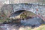 | |||
| Clachnabrain Farmhouse | 56°46′57″N 3°01′35″W | Category C(S) | 4780 | | |||
| Braeminzion School Bridge Over River South Esk | 56°47′25″N 3°02′31″W | Category B | 4784 | | |||
| Glen Clova, Newbigging | 56°49′46″N 3°04′30″W | Category C(S) | 4787 | | |||
| Airlie Memorial Tower, Tulloch Hill | 56°44′22″N 3°01′29″W | Category B | 4804 | 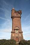 | |||
| Spott Farmhouse | 56°46′28″N 3°05′48″W | Category C(S) | 4810 | | |||
| Inchmill Cottage Pitcarity | 56°46′46″N 3°06′07″W | Category C(S) | 4816 | | |||
| Braeminzion School, Now "Wateresk House" (Glen) | 56°47′23″N 3°02′36″W | Category B | 4783 | | |||
| Rottal Bridge Over Rottal Burn | 56°48′37″N 3°02′01″W | Category C(S) | 4785 | | |||
| Rottal Lodge | 56°48′52″N 3°01′43″W | Category C(S) | 4786 | | |||
| Clova Parish Church With Churchyard (Former Church Of Scotland) | 56°50′37″N 3°06′18″W | Category C(S) | 4788 | 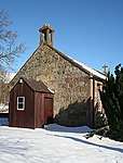 | |||
| Clova, Old Mill | 56°50′40″N 3°06′18″W | Category C(S) | 4793 | 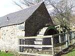 | |||
| Buckhood Bridge Over Burn Of Glencally | 56°45′33″N 3°03′37″W | Category C(S) | 4808 | 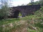 | |||
| Cortachy Castle - The Grey Lodge | 56°43′32″N 2°59′23″W | Category B | 4826 | 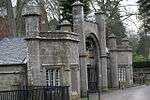 | |||
| Cortachy - River Cottage | 56°43′23″N 2°58′52″W | Category C(S) | 4834 | | |||
| Clova, Brandyburn House (Former Manse) | 56°43′27″N 2°59′26″W | Category C(S) | 4790 | | |||
| Cortachy - Airlie Lodge | 56°42′55″N 2°59′00″W | Category B | 4798 | | |||
| Glenprosen Kirkyard | 56°46′41″N 3°06′04″W | Category B | 4812 | | |||
| Cortachy Parish Kirk | 56°43′31″N 2°59′22″W | Category B | 4824 | 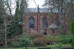 | |||
| Cortachy War Memorial | 56°43′23″N 2°59′42″W | Category C(S) | 4830 | | |||
| Cortachy - Stables | 56°43′18″N 2°58′56″W | Category B | 4832 | |
Key
The scheme for classifying buildings in Scotland is:
- Category A: "buildings of national or international importance, either architectural or historic; or fine, little-altered examples of some particular period, style or building type."[1]
- Category B: "buildings of regional or more than local importance; or major examples of some particular period, style or building type, which may have been altered."[1]
- Category C: "buildings of local importance; lesser examples of any period, style, or building type, as originally constructed or moderately altered; and simple traditional buildings which group well with other listed buildings."[1]
In March 2016 there were 47,288 listed buildings in Scotland. Of these, 8% were Category A, and 50% were Category B, with the remaining 42% being Category C.[2]
gollark: What *is* coollookingness anyway?
gollark: How'd you get redstone?
gollark: But you might need mushrooms or whatever goes into that! They're not free!
gollark: Ooh, have you written a constitution for your government?
gollark: Er, didn't two of those power plants *explode*?
See also
Notes
- Sometimes known as OSGB36, the grid reference (where provided) is based on the British national grid reference system used by the Ordnance Survey.
• "Guide to National Grid". Ordnance Survey. Retrieved 2007-12-12.
• "Get-a-map". Ordnance Survey. Retrieved 2007-12-17. - Historic Environment Scotland assign a unique alphanumeric identifier to each designated site in Scotland, for listed buildings this always begins with "LB", for example "LB12345".
References
- All entries, addresses and coordinates are based on data from Historic Scotland. This data falls under the Open Government Licence
- "What is Listing?". Historic Environment Scotland. Retrieved 29 May 2018.
- Scotland's Historic Environment Audit 2016 (PDF). Historic Environment Scotland and the Built Environment Forum Scotland. pp. 15–16. Retrieved 29 May 2018.
This article is issued from Wikipedia. The text is licensed under Creative Commons - Attribution - Sharealike. Additional terms may apply for the media files.