List of listed buildings in Collessie, Fife
List
| Name | Location | Date Listed | Grid Ref. [note 1] | Geo-coordinates | Notes | LB Number [note 2] | Image |
|---|---|---|---|---|---|---|---|
| Estate Cottage To North Of Kinloch Farm | 56°17′50″N 3°09′45″W | Category B | 4303 |  | |||
| Charlottetown Woodside Cottages (North Cottage Only) | 56°17′02″N 3°08′43″W | Category C(S) | 2439 | | |||
| Daft Mill Cart Shed | 56°17′51″N 3°06′15″W | Category C(S) | 2451 | | |||
| Trafalgar Cornhill Farmhouse | 56°18′17″N 3°09′56″W | Category B | 2458 | | |||
| Collessie Village Collessie Parish, Kirk | 56°18′22″N 3°09′19″W | Category B | 2463 | 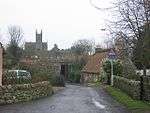 | |||
| Collessie Village Outbuilding To Rear Of The Glebe | 56°18′22″N 3°09′17″W | Category C(S) | 2466 | | |||
| Lochieheads House | 56°18′17″N 3°12′27″W | Category C(S) | 2481 | | |||
| Newton Of Collessie Walled Garden To Farmhouse | 56°18′14″N 3°08′44″W | Category C(S) | 2489 | | |||
| Newton Of Collessie - Steading And Farmbuildings | 56°18′17″N 3°08′47″W | Category B | 2490 | | |||
| Bowhouse Farmhouse | 56°16′38″N 3°10′50″W | Category C(S) | 2435 | | |||
| Charlottetown Former United Free Church Hall | 56°17′02″N 3°08′41″W | Category C(S) | 2438 | | |||
| Trafalgar Collessie Primary School | 56°18′13″N 3°09′42″W | Category B | 2457 | | |||
| Charlottetown Woodside House | 56°17′04″N 3°08′44″W | Category C(S) | 2462 | | |||
| Collessie Village Lomondview | 56°18′21″N 3°09′21″W | Category C(S) | 2471 | | |||
| Collessie Village West End (Mrs Scott And Mrs Watt) | 56°18′20″N 3°09′27″W | Category B | 2474 | | |||
| Ladybank Station,Carriage Shed And Workshops | 56°16′41″N 3°07′21″W | Category B | 2478 | | |||
| Ladybank Station Former Lodge And Ticket Office On East Platform | 56°16′25″N 3°07′16″W | Category B | 2479 | | |||
| Lochieheads House Stable Block | 56°18′17″N 3°12′29″W | Category C(S) | 2482 | | |||
| Melville Home Farm | 56°18′31″N 3°08′16″W | Category B | 2485 | | |||
| Giffordtown, Easter Kilwhiss, Bridge Over Rossie Drain | 56°16′48″N 3°10′09″W | Category C(S) | 47153 | | |||
| Rustic Summerhouse North Of Kinloch Farm | 56°17′50″N 3°09′44″W | Category C(S) | 4304 | | |||
| Cairnfield Farm Steadings | 55°45′17″N 4°41′04″W | Category C(S) | 2436 | | |||
| Trafalgar Cornhill Farm Steadings | 56°18′19″N 3°09′55″W | Category B | 2459 | | |||
| Collessie Village Collessie Kirkyard Dyke | 56°18′21″N 3°09′19″W | Category B | 2464 | | |||
| Collessie Village Sunnyview | 56°18′22″N 3°09′21″W | Category C(S) | 2467 | | |||
| Collessie Village Washhouse Property Of Mr Stark, Lomondview | 56°18′21″N 3°09′22″W | Category C(S) | 2476 | | |||
| Rossie Farm Steadings And Outbuildings | 56°17′58″N 3°12′10″W | Category B | 2499 | | |||
| Gatepiers And Walls At West Lodge, Ladybank Road | 56°16′24″N 3°07′13″W | Category B | 2526 | | |||
| Collessie Village Cottage Adjoining Sunnyview | 56°18′22″N 3°09′20″W | Category C(S) | 2468 | | |||
| Collessie Village Ivy Cottage And Garden House | 56°18′23″N 3°09′21″W | Category C(S) | 2469 | | |||
| Kinloch House, North Lodge | 56°18′02″N 3°09′43″W | Category C(S) | 2477 | | |||
| Newton Of Collessie Farmhouse | 56°18′14″N 3°08′47″W | Category B | 2488 | | |||
| Rossie Farmhouse | 56°17′56″N 3°12′08″W | Category B | 2498 | | |||
| Kinloch Former Lodge House | 56°17′50″N 3°09′42″W | Category C(S) | 2522 | | |||
| Kinloch House, Dovecote | 56°17′46″N 3°09′53″W | Category B | 4305 | | |||
| Annsmuir House, Horsemill | 56°17′18″N 3°06′39″W | Category B | 2434 | | |||
| Collessie Village Washhouse Property Of Braehead | 56°18′21″N 3°09′22″W | Category C(S) | 2447 | | |||
| Easter Kilwhiss Farm Range Of Steadings And Cart Shed | 56°17′01″N 3°09′58″W | Category B | 2452 | | |||
| Edenbank Roadbridge (A914) | 56°15′51″N 3°08′33″W | Category C(S) | 2453 | | |||
| Heatherinch Farm, Barn, Ladybank Road | 56°16′18″N 3°07′12″W | Category C(S) | 2454 | | |||
| Kinloch Farmhouse And Offices | 56°17′47″N 3°09′42″W | Category B | 2456 | | |||
| Lumquat Mill And Cottage | 56°18′34″N 3°14′03″W | Category C(S) | 2484 | | |||
| Shiells/Lathrisk Roadbridge (Unclassified Road) | 56°15′51″N 3°09′29″W | Category C(S) | 2500 | | |||
| Collessie Village Strad Cottage And Manse Gates | 56°18′22″N 3°09′15″W | Category C(S) | 153 | | |||
| Collessie Village Lomond View (Mr Stark) | 56°18′21″N 3°09′20″W | Category C(S) | 154 | | |||
| Meadowwells House Outbuilding | 56°18′26″N 3°10′40″W | Category C(S) | 4307 | | |||
| Collessie Village The Wee Hoose In Grounds Of Cedar House | 56°18′22″N 3°09′11″W | Category B | 2449 | | |||
| Kinloch House | 56°17′52″N 3°09′55″W | Category B | 2455 | | |||
| Trafalgar The Smithy | 56°18′12″N 3°09′49″W | Category C(S) | 2461 | | |||
| Collessie Village Braehead | 56°18′21″N 3°09′20″W | Category B | 2470 | | |||
| Melville House Dovecote | 56°18′04″N 3°07′42″W | Category B | 2486 | | |||
| Pitlair House | 56°17′46″N 3°06′05″W | Category B | 2492 | | |||
| Pitlair House Pair Of Gatepiers At South Driveway | 56°17′39″N 3°05′53″W | Category C(S) | 2494 | | |||
| Rankeilour Bridge Over Rankeilour Burn At No 3276 1186 | 56°17′40″N 3°05′16″W | Category C(S) | 2495 | | |||
| Meadowwells House | 56°18′26″N 3°10′38″W | Category C(S) | 4306 | | |||
| Collessie Village Station House | 56°18′27″N 3°09′25″W | Category B | 2473 | | |||
| Ladybank Station (East Block) | 56°16′27″N 3°07′17″W | Category B | 2480 | | |||
| Melville Muir Cottages | 56°17′34″N 3°06′45″W | Category C(S) | 2487 | | |||
| Newton Of Collessie Standing Stone | 56°18′23″N 3°08′41″W | Category B | 2491 | | |||
| West Lodge Ladybank Road | 56°16′25″N 3°07′13″W | Category C(S) | 2525 | | |||
| Bridge Over Rankeilour Burn At No 3326 1098 | 56°17′12″N 3°04′46″W | Category C(S) | 45596 | | |||
| Cairnfield Cottages | 56°17′04″N 3°07′55″W | Category C(S) | 2437 | | |||
| Collessie Village Southview (Mrs Rennie) | 56°18′20″N 3°09′25″W | Category C(S) | 2448 | | |||
| Daft Mill And Farm Buildings | 56°17′50″N 3°06′15″W | Category B | 2450 | | |||
| Trafalgar Smithy House | 56°18′13″N 3°09′50″W | Category C(S) | 2460 | | |||
| Collessie Village The Glebe | 56°18′21″N 3°09′17″W | Category B | 2465 | | |||
| Collessie Village Rose Cottage | 56°18′23″N 3°09′23″W | Category B | 2472 | | |||
| Collessie Village Washhouse Mrs Watt, West End | 56°18′20″N 3°09′26″W | Category C(S) | 2475 | | |||
| Lumquat Farmhouse | 56°18′36″N 3°13′32″W | Category C(S) | 2483 | | |||
| Pitlair Dovecot | 56°17′44″N 3°06′12″W | Category B | 2493 | | |||
| Rossie House | 56°17′44″N 3°11′20″W | Category B | 2496 | | |||
| Rossie House Home Farm Cartshed | 56°17′45″N 3°11′19″W | Category B | 2497 | | |||
| Weddersbie Farmhouse | 56°18′15″N 3°11′44″W | Category C(S) | 2523 | | |||
| Wellwood House Ladybank Road | 56°16′17″N 3°07′07″W | Category C(S) | 2524 | |
Key
The scheme for classifying buildings in Scotland is:
- Category A: "buildings of national or international importance, either architectural or historic; or fine, little-altered examples of some particular period, style or building type."[1]
- Category B: "buildings of regional or more than local importance; or major examples of some particular period, style or building type, which may have been altered."[1]
- Category C: "buildings of local importance; lesser examples of any period, style, or building type, as originally constructed or moderately altered; and simple traditional buildings which group well with other listed buildings."[1]
In March 2016 there were 47,288 listed buildings in Scotland. Of these, 8% were Category A, and 50% were Category B, with the remaining 42% being Category C.[2]
gollark: <@!683735247489466397> play https://radio-ic.osmarks.net/128k.ogg
gollark: <@!683735247489466397> play https://radio-ic.osmarks.net/128k.ogg
gollark: <@!683735247489466397> play https://radio-ic.osmarks.net/128k.ogg
gollark: <@!683735247489466397> play https://radio-ic.osmarks.net/128k.ogg
gollark: <@!683735247489466397> play https://radio-ic.osmarks.net/128k.ogg
See also
Notes
- Sometimes known as OSGB36, the grid reference (where provided) is based on the British national grid reference system used by the Ordnance Survey.
• "Guide to National Grid". Ordnance Survey. Retrieved 2007-12-12.
• "Get-a-map". Ordnance Survey. Retrieved 2007-12-17. - Historic Environment Scotland assign a unique alphanumeric identifier to each designated site in Scotland, for listed buildings this always begins with "LB", for example "LB12345".
References
- All entries, addresses and coordinates are based on data from Historic Scotland. This data falls under the Open Government Licence
- "What is Listing?". Historic Environment Scotland. Retrieved 29 May 2018.
- Scotland's Historic Environment Audit 2016 (PDF). Historic Environment Scotland and the Built Environment Forum Scotland. pp. 15–16. Retrieved 29 May 2018.
This article is issued from Wikipedia. The text is licensed under Creative Commons - Attribution - Sharealike. Additional terms may apply for the media files.