List of listed buildings in Ceres, Fife
List
| Name | Location | Date Listed | Grid Ref. [note 1] | Geo-coordinates | Notes | LB Number [note 2] | Image |
|---|---|---|---|---|---|---|---|
| Bridge Over Ceres Burn, South Of Pitscottie | 56°18′05″N 2°56′46″W | Category B | 6501 |  | |||
| Ceres, Saughtree, Main Street, House, Store And Garages | 56°17′40″N 2°58′34″W | Category C(S) | 4286 | | |||
| High Street, House And Shop ( James Walker) | 56°17′32″N 2°58′14″W | Category C(S) | 4292 | | |||
| High Street, Kirphon | 56°17′32″N 2°58′14″W | Category C(S) | 4294 | | |||
| Teassesmill Bridge | 56°17′08″N 2°58′19″W | Category B | 2424 | | |||
| Dairy, Castlegate, Ceres | 56°17′30″N 2°58′12″W | Category C(S) | 2371 | | |||
| Castlegate Farmhouse Castlegate, Ceres | 56°17′30″N 2°58′12″W | Category C(S) | 2372 | | |||
| 15 Main Street, Plumtree Cottage | 56°17′34″N 2°58′15″W | Category B | 2383 | | |||
| Cottage At East Gate, Baltilly, Formerly Occupied By James Archibald | 56°17′36″N 2°58′29″W | Category C(S) | 2386 | | |||
| Southern Outbuilding Of Brand's Hotel, High Street, Ceres | 56°17′31″N 2°58′14″W | Category A | 2393 | .jpg) | |||
| Castle House, Anstruther Road, Ceres | 56°17′32″N 2°58′04″W | Category C(S) | 2397 | | |||
| Cummerfield Cottage, Anstruther Road, Ceres | 56°17′32″N 2°58′04″W | Category C(S) | 2398 | | |||
| Ceres, Kirklands, 43 Main Street | 56°17′39″N 2°58′24″W | Category C(S) | 4285 | | |||
| Bridgend, Dam Bridge | 56°17′41″N 2°58′35″W | Category B | 4295 | | |||
| Bridgend, Gatepiers To Eastmost House On S Side Of New Town, West Of Bridge | 56°17′41″N 2°58′37″W | Category C(S) | 4296 | | |||
| Scotstarvit Tower | 56°17′23″N 3°01′08″W | Category A | 2416 | | |||
| Craigrothie, Footbridge | 56°17′21″N 3°00′01″W | Category B | 2419 | | |||
| Kilhill Bridge Over Ceres Burn | 56°17′57″N 2°57′35″W | Category C(S) | 2427 | | |||
| Struthers Doocot | 56°16′33″N 3°00′27″W | Category B | 2431 | | |||
| Loch Houses | 56°17′29″N 2°58′25″W | Category C(S) | 2442 | | |||
| Baltilly, House And Walled Garden With Sundial | 56°17′35″N 2°58′32″W | Category B | 2384 | | |||
| Viewfield Cottage St Andrew's Road Including Garden Walls And Gatepiers | 56°17′37″N 2°58′02″W | Category B | 2391 | | |||
| Fife Folk Museum (Central And North Fife Preservation Society) High Street, Ceres[1] | 56°17′31″N 2°58′14″W[2]) | Category A | 2394 | .jpg) | |||
| Old Manse, Anstruther Road, Ceres | 56°17′29″N 2°58′01″W | Category B | 2403 | | |||
| Smithy Cottage And Smith, Schoolhill, Junction With Anstruther Road | 56°17′33″N 2°58′04″W | Category C(S) | 2405 | | |||
| Restalrig And Marlowes, Schoolhill, Ceres | 56°17′33″N 2°58′02″W | Category C(S) | 2407 | | |||
| Craighall Den, Ceres, Limekiln | 56°17′03″N 2°57′25″W | Category B | 51767 | | |||
| Greenside Farm Steading | 56°15′17″N 2°58′52″W | Category A | 4302 | 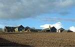 | |||
| Teasses Estate, Walled Garden | 56°15′42″N 2°57′11″W | Category C(S) | 3436 | | |||
| Teasses House, Gatelodge | 56°15′35″N 2°57′56″W | Category B | 3437 | | |||
| Bow Butts Bridge - Bannockburn Monument | 56°17′31″N 2°58′17″W | Category C(S) | 2409 | | |||
| House (Jasmine S Mair) South Croftdyke, Ceres | 56°17′29″N 2°58′19″W | Category C(S) | 2412 | | |||
| Bridge Over Ceres Burn, On B939, West Side Pitscottie | 56°18′20″N 2°56′47″W | Category C(S) | 2428 | | |||
| Wood End Cottage, North Croftdyke, Ceres | 56°17′33″N 2°58′23″W | Category C(S) | 2441 | | |||
| Edenwood Home Farm (Front Nw Part Only) | 56°17′40″N 3°02′10″W | Category B | 2444 | | |||
| Crawford Priory East Gate Gate Piers On A92 Near Clushford Toll | 56°17′28″N 3°02′33″W | Category C(S) | 2446 | | |||
| Kirk Brae Lindsay Vault, Parish Churchyard (Formerly Main Street), Ceres | 56°17′37″N 2°58′18″W | Category B | 2365 | 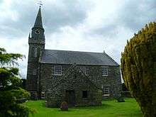 | |||
| St John's Masonic Lodge Off High Street, Ceres, Including Garden Walls | 56°17′29″N 2°58′13″W | Category A | 2368 | .jpg) | |||
| Kimberley (Former Parish School) 33 Main Street, Ceres Including Garden Walls | 56°17′37″N 2°58′21″W | Category B | 2380 | | |||
| 1 Main Street, The Cross, Corner St Andrew's Road (Mrs Cunningham) | 56°17′33″N 2°58′13″W | Category C(S) | 2382 | | |||
| Cottage (A Macdonald), Baltilly | 56°17′36″N 2°58′28″W | Category C(S) | 2387 | | |||
| Castle Bank, Anstruther Road, Ceres | 56°17′32″N 2°58′04″W | Category C(S) | 2396 | | |||
| High Street, Burnview | 56°17′32″N 2°58′14″W | Category B | 4293 | | |||
| Craigrothie House, Icehouse And Screen Wall Linked To House | 56°17′18″N 3°00′02″W | Category B | 4300 | | |||
| House (John Webster, Southern House), South Croftdyke, Ceres | 56°17′29″N 2°58′18″W | Category C(S) | 2414 | | |||
| Wellwood, Well | 56°17′54″N 2°57′40″W | Category B | 2425 | | |||
| Gathercauld Bridge Over Craighall Burn | 56°16′29″N 2°56′06″W | Category C(S) | 2429 | | |||
| Teasses House | 56°15′42″N 2°57′30″W | Category B | 2430 | | |||
| Kirk Brae Ceres Parish Churchyard (Formerly Main Street), Ceres | 56°17′37″N 2°58′16″W | Category C(S) | 2364 | | |||
| Bishop Bridge Over Ceres Burn, Including Approach Walls Linking To Folk Museum, Ceres | 56°17′29″N 2°58′14″W | Category A | 2366 | 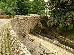 | |||
| 1 Kirk Brae Parish Church Hall (Formerly 31 Main Street), Ceres | 56°17′36″N 2°58′17″W | Category B | 2379 | | |||
| Brand's Hotel, High Street, Ceres Including North-West Wing | 56°17′31″N 2°58′15″W | Category B | 2392 | | |||
| War Memorial Hall, Anstruther Road, Ceres | 56°17′30″N 2°58′02″W | Category B | 2402 | | |||
| Main Street, Premises Formerly P Butt And Sons, Ceres | 56°17′37″N 2°58′22″W | Category C(S) | 4287 | | |||
| 56 Main Street, Meldrum's Hotel | 56°17′37″N 2°58′25″W | Category C(S) | 4289 | | |||
| Teasses Estate, Steading | 56°15′43″N 2°57′27″W | Category B | 3435 | | |||
| House (David Kidd) South Croftdyke Ceres | 56°17′30″N 2°58′19″W | Category C(S) | 2411 | | |||
| Hill Of Tarvit Dovecot | 56°17′30″N 3°00′23″W | Category B | 2418 | | |||
| Mile Plate On A92 Near Tarvit Mill | 56°18′02″N 3°01′41″W | Category B | 2445 | | |||
| Dunroamin, Bishop Bridge Off High Street, Ceres | 56°17′30″N 2°58′13″W | Category C(S) | 2367 | | |||
| Wilbra Cottage, South Croftdyke, Ceres | 56°17′28″N 2°58′19″W | Category C(S) | 2375 | | |||
| Coachhouse And Offices, Baltilly | 56°17′35″N 2°58′30″W | Category C(S) | 2385 | | |||
| St Helens, St Andrew's Road | 56°17′37″N 2°58′07″W | Category B | 2390 | | |||
| 17,19 Main Street | 56°17′35″N 2°58′15″W | Category B | 4284 | | |||
| 54 Main Street | 56°17′36″N 2°58′22″W | Category C(S) | 4288 | | |||
| Bridgend House Including Ancillary Structures, Gatepiers, Boundary Walls And Walled Garden And 1 And 2 Back Latch, Bridgend Cottage | 56°17′44″N 2°58′39″W | Category B | 4299 | | |||
| Craigrothie Mill And Detached Garage Block | 56°17′18″N 3°00′01″W | Category B | 2421 | | |||
| Kilhill House | 56°17′57″N 2°57′32″W | Category C(S) | 2426 | | |||
| 3 Kirk Brae Ceres Parish Church (Formerly Main Street) Ceres | 56°17′37″N 2°58′19″W | Category B | 2363 | | |||
| Castlegate Farm, Castlegate, Ceres | 56°17′31″N 2°58′10″W | Category C(S) | 2373 | | |||
| House And Shop (G Donaldson) Almac, Windsor House, Anstruther Road, Ceres | 56°17′33″N 2°58′08″W | Category C(S) | 2374 | | |||
| 17 Kirk Brae Mansefield (Former Manse) And Offices Curling Pond Road Off Main Street) | 56°17′40″N 2°58′21″W | Category B | 2381 | | |||
| Ceres Inn (Former Volunteer Arms) The Cross, St Andrew's Road And Main Street, Ceres | 56°17′33″N 2°58′15″W | Category B | 2388 | | |||
| Store Building Adjoining St Margaret's On East, Anstruther Road, Ceres | 56°17′33″N 2°58′07″W | Category C(S) | 2395 | | |||
| Premises (D Kitching) Anstruther Road, Ceres | 56°17′31″N 2°58′03″W | Category C(S) | 2401 | | |||
| Struthers Castle | 56°16′32″N 3°00′26″W | Category B | 152 | | |||
| St Andrew Road, The Cross, House (Beaton) | 56°17′33″N 2°58′13″W | Category B | 4290 | | |||
| Bridgend, Catherine Bank, Coach House | 56°17′43″N 2°58′38″W | Category B | 4298 | | |||
| House (John Webster, Northern House), South Croftdyke, Ceres | 56°17′29″N 2°58′19″W | Category C(S) | 2413 | | |||
| Crawford Priory The Kennels Cottage (Near Clushford Toll) | 56°17′29″N 3°02′38″W | Category B | 2415 | | |||
| Craigrothie House | 56°17′18″N 3°00′03″W | Category B | 2417 | | |||
| Craigrothie Doocot | 56°17′15″N 3°00′03″W | Category B | 2420 | | |||
| Ye Kingarrach Inn (Formerly Craigrothie Inn), Main Street, Craigrothie | 56°17′13″N 3°00′18″W | Category B | 2422 | | |||
| Craigrothie Bridge Over Craigrothie Burn | 56°17′15″N 3°00′19″W | Category C(S) | 2423 | | |||
| Struthers Farmhouse | 56°16′35″N 3°00′23″W | Category C(S) | 2432 | | |||
| Orchard Vaults And Associated Garden Walls, South Of St John's Lodge, Ceres | 56°17′27″N 2°58′14″W | Category B | 2369 | | |||
| House (J W Mitchell) North Croftdyke, Ceres | 56°17′32″N 2°58′20″W | Category C(S) | 2377 | | |||
| Cottages (Now Incorporated Into J W Mitchell's House) North Croftdyke, Ceres | 56°17′32″N 2°58′21″W | Category C(S) | 2378 | | |||
| Ceres Academy Schoolmaster's House Schoolhill, Ceres | 56°17′35″N 2°58′02″W | Category B | 2406 | | |||
| High Street, The Provost | 56°17′32″N 2°58′13″W | Category B | 4291 | | |||
| Bridgend, Catherine Bank | 56°17′44″N 2°58′37″W | Category B | 4297 | | |||
| Teassesmill House | 56°17′07″N 2°58′21″W | Category B | 4301 | | |||
| Bog Well, South Croftdyke, Ceres | 56°17′29″N 2°58′18″W | Category B | 2410 | | |||
| St Margaret's, Anstruther Road, Ceres | 56°17′33″N 2°58′08″W | Category C(S) | 2433 | | |||
| Croft House North Croftdyke, Ceres | 56°17′32″N 2°58′22″W | Category C(S) | 2440 | | |||
| Edenwood House | 56°17′43″N 3°02′31″W | Category B | 2443 | | |||
| House (Mckellar) Castlegate, Ceres | 56°17′30″N 2°58′13″W | Category C(S) | 2370 | | |||
| House (A D Mitchell) North Croftdyke, Ceres | 56°17′31″N 2°58′20″W | Category C(S) | 2376 | | |||
| St Ann's St Andrew's Road, Ceres | 56°17′34″N 2°58′11″W | Category B | 2389 | | |||
| Cottage (Mary L Borland) Anstruther Road, Ceres | 56°17′31″N 2°58′04″W | Category C(S) | 2399 | | |||
| Cottage (J P Robertson) Anstruther Road, Ceres Including Garden Wall | 56°17′31″N 2°58′04″W | Category C(S) | 2400 | | |||
| Bow Butts Bridge Over Ceres Burn Including Parapet Walls Of Approaches | 56°17′32″N 2°58′16″W | Category B | 2408 | |
Key
The scheme for classifying buildings in Scotland is:
- Category A: "buildings of national or international importance, either architectural or historic; or fine, little-altered examples of some particular period, style or building type."[4]
- Category B: "buildings of regional or more than local importance; or major examples of some particular period, style or building type, which may have been altered."[4]
- Category C: "buildings of local importance; lesser examples of any period, style, or building type, as originally constructed or moderately altered; and simple traditional buildings which group well with other listed buildings."[4]
In March 2016 there were 47,288 listed buildings in Scotland. Of these, 8% were Category A, and 50% were Category B, with the remaining 42% being Category C.[5]
gollark: I manage all my media stuff with a bunch of nested folders on my server and a thing to expose it on HTTP (with basic auth).
gollark: Some are waaaaay more than that.
gollark: Also quite a bit of random cash.
gollark: I have a debit card, but I also only have £1.90 of money.
gollark: If I'm going to actually buy one I want a cool short one which I can type in 6 characters, which is possible without even spending giant amounts of money.
See also
Notes
- Sometimes known as OSGB36, the grid reference (where provided) is based on the British national grid reference system used by the Ordnance Survey.
• "Guide to National Grid". Ordnance Survey. Retrieved 2007-12-12.
• "Get-a-map". Ordnance Survey. Retrieved 2007-12-17. - Historic Environment Scotland assign a unique alphanumeric identifier to each designated site in Scotland, for listed buildings this always begins with "LB", for example "LB12345".
References
- All entries, addresses and coordinates are based on data from Historic Scotland. This data falls under the Open Government Licence
- "Home". Fife Folk Museum.
- "Home". Fife Folk Museum.
- "Home". Fife Folk Museum.
- "What is Listing?". Historic Environment Scotland. Retrieved 29 May 2018.
- Scotland's Historic Environment Audit 2016 (PDF). Historic Environment Scotland and the Built Environment Forum Scotland. pp. 15–16. Retrieved 29 May 2018.
This article is issued from Wikipedia. The text is licensed under Creative Commons - Attribution - Sharealike. Additional terms may apply for the media files.