List of listed buildings in Cawdor, Highland
List
| Name | Location | Date Listed | Grid Ref. [note 1] | Geo-coordinates | Notes | LB Number [note 2] | Image |
|---|---|---|---|---|---|---|---|
| Brackla House And Walled Garden | 57°32′15″N 3°54′20″W | Category B | 1726 |  | |||
| Clunas | 57°29′41″N 3°52′01″W | Category B | 1737 | | |||
| Cawdor Village Old Change House | 57°31′39″N 3°55′36″W | Category C(S) | 1752 | | |||
| Cawdor Village West End West End Cottage (Immediately West Of Ivy Cottage) | 57°31′23″N 3°56′09″W | Category C(S) | 1754 | | |||
| Cawdor Village West End Ivy Cottage | 57°31′24″N 3°56′08″W | Category C(S) | 1755 | | |||
| Cawdor Castle Home Farm Granary | 57°31′27″N 3°55′21″W | Category B | 1732 | | |||
| Meikle Urchany | 57°31′40″N 3°52′08″W | Category B | 1738 | | |||
| Newton Of Budgate | 57°31′27″N 3°57′30″W | Category B | 1739 | | |||
| Cawdor Village County Salon (Former Post Office) And Former Post Office House | 57°31′32″N 3°55′40″W | Category C(S) | 1767 | | |||
| Cawdor Castle, East Lodge | 57°31′20″N 3°55′15″W | Category C(S) | 1731 | | |||
| Cawdor Village Bridge House | 57°31′33″N 3°55′39″W | Category C(S) | 1733 | | |||
| Cawdor Village Lavender Cottage | 57°31′31″N 3°55′50″W | Category B | 1736 | | |||
| Bareven Bridge Over The Allt Dearg, Wester Bareven | 57°29′57″N 3°57′26″W | Category C(S) | 1724 | | |||
| Cawdor Castle Walled Garden | 57°31′25″N 3°55′33″W | Category B | 1729 | | |||
| Cawdor Village Fountainsyde (L) And Hillview (R) | 57°31′33″N 3°55′44″W | Category C(S) | 1734 | | |||
| Cawdor Village Old Manse Walled Garden, Steading And Gate Piers | 57°31′22″N 3°56′23″W | Category B | 1753 | | |||
| Cawdor Village Off Back Street Church Hall | 57°31′26″N 3°55′56″W | Category C(S) | 1761 | | |||
| Cawdor Village, Back Street The Rockery | 57°31′29″N 3°55′48″W | Category C(S) | 1764 | | |||
| Auchindoune House | 57°30′26″N 3°56′26″W | Category B | 1723 | | |||
| Cawdor Castle | 57°31′27″N 3°55′36″W | Category A | 1728 | 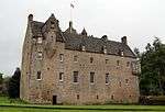 | |||
| Cawdor Village West End Cottage (Opposite South Entrance To Parish Church) | 57°31′26″N 3°55′59″W | Category C(S) | 1759 | | |||
| Cawdor Village Cawdor Parish Church And Burial Ground | 57°31′29″N 3°55′57″W | Category A | 1760 | 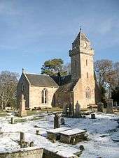 | |||
| Cawdor Village Back Street West End House, Post Office And Former Stables | 57°31′28″N 3°55′55″W | Category C(S) | 1763 | | |||
| Cawdor Village Back Street The Schoolhouse | 57°31′29″N 3°55′44″W | Category C(S) | 1765 | | |||
| Cawdor Village Back Street South House | 57°31′29″N 3°55′44″W | Category C(S) | 1766 | | |||
| Bareven Church Kirkton Of Bareven | 57°30′02″N 3°56′34″W | Category B | 1725 | | |||
| Budgate House | 57°31′14″N 3°56′42″W | Category A | 1727 | 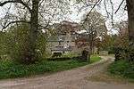 | |||
| Cawdor Castle Gate Lodge And Entrance | 57°31′31″N 3°55′37″W | Category B | 1730 | | |||
| Cawdor Village West End Rowan Cottage (L) And Mrs Cameron's Cottage (R) | 57°31′24″N 3°56′06″W | Category C(S) | 1756 | | |||
| Cawdor Village West End Memorial Cottage | 57°31′25″N 3°56′04″W | Category C(S) | 1757 | | |||
| Cawdor Village Gardener's Cottage | 57°31′33″N 3°55′48″W | Category C(S) | 1735 | | |||
| Cawdor Village Meadowbank | 57°31′24″N 3°56′02″W | Category C(S) | 1758 | | |||
| Cawdor Village Off Back Street The Mound | 57°31′26″N 3°55′54″W | Category C(S) | 1762 | |
Key
The scheme for classifying buildings in Scotland is:
- Category A: "buildings of national or international importance, either architectural or historic; or fine, little-altered examples of some particular period, style or building type."[1]
- Category B: "buildings of regional or more than local importance; or major examples of some particular period, style or building type, which may have been altered."[1]
- Category C: "buildings of local importance; lesser examples of any period, style, or building type, as originally constructed or moderately altered; and simple traditional buildings which group well with other listed buildings."[1]
In March 2016 there were 47,288 listed buildings in Scotland. Of these, 8% were Category A, and 50% were Category B, with the remaining 42% being Category C.[2]
gollark: I was replying to BearcatBen with the "People who need them?" thing, but oh well, ye,s very edgy.
gollark: > Why so?I mean, for one thing, I care about... quality of life? general stability? Lots of things OTHER than just technology? For another, why would ancap magically improve advancement?
gollark: People who need them?
gollark: That's a terrible view and probably not even a very consistent one.
gollark: That sentence does NOT parse properly.
See also
Notes
- Sometimes known as OSGB36, the grid reference (where provided) is based on the British national grid reference system used by the Ordnance Survey.
• "Guide to National Grid". Ordnance Survey. Retrieved 2007-12-12.
• "Get-a-map". Ordnance Survey. Retrieved 2007-12-17. - Historic Environment Scotland assign a unique alphanumeric identifier to each designated site in Scotland, for listed buildings this always begins with "LB", for example "LB12345".
References
- All entries, addresses and coordinates are based on data from Historic Scotland. This data falls under the Open Government Licence
- "What is Listing?". Historic Environment Scotland. Retrieved 29 May 2018.
- Scotland's Historic Environment Audit 2016 (PDF). Historic Environment Scotland and the Built Environment Forum Scotland. pp. 15–16. Retrieved 29 May 2018.
This article is issued from Wikipedia. The text is licensed under Creative Commons - Attribution - Sharealike. Additional terms may apply for the media files.