List of listed buildings in Carrington, Midlothian
List
| Name | Location | Date Listed | Grid Ref. [note 1] | Geo-coordinates | Notes | LB Number [note 2] | Image |
|---|---|---|---|---|---|---|---|
| Carrington Village, Carrington Mains Steading | 55°49′59″N 3°05′20″W | Category B | 680 |  | |||
| Whitehill Policies, Whitehill House, Former St Joseph's Institution | 55°50′46″N 3°07′34″W | Category A | 687 | | |||
| Carrington Village, 1-8 (Inclusive) Primrose Gardens | 55°50′02″N 3°05′19″W | Category C(S) | 46087 | 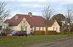 | |||
| Shewington Farmhouse, Including Bothy | 55°49′53″N 3°08′27″W | Category C(S) | 46091 | | |||
| Whitehill Policies, St Mary's Lodge And Gatepiers And Gates To Whitehill House | 55°50′41″N 3°07′14″W | Category C(S) | 46092 | | |||
| Thornton Farm, Dovecot | 55°50′32″N 3°07′42″W | Category B | 45568 | | |||
| Carrington Village, Carrington Kirk, Including Gates, Gatepiers And Boundary Walls | 55°50′01″N 3°05′22″W | Category B | 6647 | 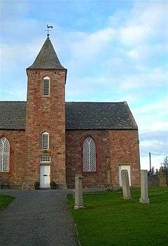 | |||
| Carrington, Main Street, 4 Carrington Mains Cottages Including Boundary Wall | 55°49′59″N 3°05′26″W | Category C(S) | 682 | | |||
| Carrington Mill, Bridge To West Over Redside Burn | 55°49′26″N 3°05′25″W | Category C(S) | 688 | | |||
| Broachrigg Farmhouse, Including Gate And Boundary Wall | 55°50′14″N 3°08′26″W | Category C(S) | 46084 | | |||
| Carrington Village, Carrington Mains Farmhouse Including Gates, Gatepiers And Boundary Walls | 55°49′58″N 3°05′21″W | Category C(S) | 46086 | | |||
| Carrington, Main Street, 2 Carrington Mains Cottages | 55°50′00″N 3°05′20″W | Category C(S) | 679 | | |||
| Carrington Burial Ground, Including Whitehill Aisle (Ramsay Mausoleum), Gatepiers And Boundary Walls | 55°50′20″N 3°05′04″W | Category B | 685 | 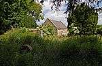 | |||
| Edgelaw Reservoir, Including Dam, Overflow, Upstand Shaft And Bridges | 55°48′39″N 3°06′44″W | Category B | 46088 | | |||
| Parduvine Farmhouse, Cartshed And Granary, And Boundary Walls | 55°50′13″N 3°06′58″W | Category B | 46089 | | |||
| Redside, Farmhouse And Steading | 55°49′22″N 3°06′31″W | Category C(S) | 46090 | | |||
| Thornton Farm, Farmhouse | 55°50′33″N 3°07′46″W | Category C(S) | 45567 | | |||
| Carrington Village, Manse Road, Carrington Hill, Formerly Carrington Manse, Including Ancillary Buildings, Walled Garden, Gates, Gatepiers And Boundary Walls | 55°49′50″N 3°05′33″W | Category C(S) | 684 | | |||
| Carrington Village, Carrington Kirk, Session House | 55°50′00″N 3°05′21″W | Category B | 677 | | |||
| Arniston Policies, Bridge Over River South Esk | 55°50′21″N 3°04′10″W | Category B | 46083 | | |||
| Carrington Mill And Mill Cottage | 55°49′28″N 3°05′20″W | Category C(S) | 46085 | | |||
| Carrington, Main Street, 3 Carrington Mains Cottages | 55°49′59″N 3°05′25″W | Category C(S) | 681 | | |||
| Thornton Farm, Ice House | 55°50′31″N 3°07′45″W | Category C(S) | 45569 | | |||
| Carrington Bridge, Over Redside Burn | 55°49′25″N 3°05′10″W | Category B | 686 | | |||
| Carrington, Main Street, 1 Carrington Mains Cottages | 55°50′00″N 3°05′18″W | Category C(S) | 678 | | |||
| Carrington Village, 5 Main Street, Including Wall To East | 55°49′58″N 3°05′27″W | Category B | 683 | | |||
| Whitehill Policies, Bridge To N Of Whitehill House | 55°50′52″N 3°07′32″W | Category C(S) | 65 | |
Key
The scheme for classifying buildings in Scotland is:
- Category A: "buildings of national or international importance, either architectural or historic; or fine, little-altered examples of some particular period, style or building type."[1]
- Category B: "buildings of regional or more than local importance; or major examples of some particular period, style or building type, which may have been altered."[1]
- Category C: "buildings of local importance; lesser examples of any period, style, or building type, as originally constructed or moderately altered; and simple traditional buildings which group well with other listed buildings."[1]
In March 2016 there were 47,288 listed buildings in Scotland. Of these, 8% were Category A, and 50% were Category B, with the remaining 42% being Category C.[2]
gollark: <@319753218592866315> <@319753218592866315> <@319753218592866315> <@319753218592866315> <@319753218592866315>
gollark: https://innative.dev/
gollark: https://github.com/AndrewScheidecker/WAVM/
gollark: http://www.simonjf.com/2018/08/27/cmm-of-wasm.html
gollark: https://github.com/WebAssembly/wabt/tree/main/wasm2c
Notes
- Sometimes known as OSGB36, the grid reference (where provided) is based on the British national grid reference system used by the Ordnance Survey.
• "Guide to National Grid". Ordnance Survey. Retrieved 2007-12-12.
• "Get-a-map". Ordnance Survey. Retrieved 2007-12-17. - Historic Environment Scotland assign a unique alphanumeric identifier to each designated site in Scotland, for listed buildings this always begins with "LB", for example "LB12345".
References
- All entries, addresses and coordinates are based on data from Historic Scotland. This data falls under the Open Government Licence
- "What is Listing?". Historic Environment Scotland. Retrieved 29 May 2018.
- Scotland's Historic Environment Audit 2016 (PDF). Historic Environment Scotland and the Built Environment Forum Scotland. pp. 15–16. Retrieved 29 May 2018.
This article is issued from Wikipedia. The text is licensed under Creative Commons - Attribution - Sharealike. Additional terms may apply for the media files.