List of listed buildings in Brechin, Angus
List
| Name | Location | Date Listed | Grid Ref. [note 1] | Geo-coordinates | Notes | LB Number [note 2] | Image |
|---|---|---|---|---|---|---|---|
| 16, 18, 20 High Street | 56°43′55″N 2°39′38″W | Category B | 22492 |  | |||
| 52, 54 High Street | 56°43′51″N 2°39′34″W | Category B | 22501 | | |||
| 68-74 High Street | 56°43′51″N 2°39′33″W | Category A | 22505 | | |||
| 13, 15 Panmure Street | 56°43′59″N 2°39′29″W | Category C(S) | 22519 | | |||
| 21, 23, 25 Panmure Street | 56°44′00″N 2°39′27″W | Category C(S) | 22521 | | |||
| 16 Panmure Street | 56°43′58″N 2°39′28″W | Category C(S) | 22526 | | |||
| 57-59 Park Road | 56°43′58″N 2°38′56″W | Category C(S) | 22534 | | |||
| Park House 69-71 Park Road | 56°43′58″N 2°38′47″W | Category C(S) | 22535 | | |||
| St Andrew's Episcopal Church Hall And Former Diocesan Library St Andrew Street | 56°43′57″N 2°39′45″W | Category C(S) | 22550 | | |||
| 1,3,5 St Mary Street | 56°43′55″N 2°39′44″W | Category C(S) | 22561 | | |||
| 6,7,8,9 St Ninian's Place | 56°43′53″N 2°39′13″W | Category C(S) | 22564 | | |||
| Lyndhurst 1 St Ninian's Square | 56°43′55″N 2°39′12″W | Category C(S) | 22566 | | |||
| 3 (Roseneath) And 5 St Ninian's Square | 56°43′56″N 2°39′12″W | Category C(S) | 22567 | | |||
| 59 Southesk Street Kingdom Hall Of Jehovah's Witnesses | 56°43′56″N 2°39′17″W | Category C(S) | 22575 | | |||
| 1,3 Swan Street And 2,4 Market Street | 56°43′57″N 2°39′36″W | Category B | 22579 | | |||
| 14-20 Swan Street (Even Numbers) | 56°43′56″N 2°39′34″W | Category C(S) | 22585 | | |||
| 22,24,26,28 Swan Street | 56°43′56″N 2°39′32″W | Category C(S) | 22586 | | |||
| Maisondieu Church, Witchden Road With Front Wall And Gatepiers | 56°43′39″N 2°39′09″W | Category B | 22588 | | |||
| Manse Bishop's Close | 56°43′52″N 2°39′36″W | Category B | 22417 | | |||
| 21, 23 Castle Street | 56°43′51″N 2°39′55″W | Category B | 22426 | | |||
| 2 Castle Street | 56°43′54″N 2°39′48″W | Category C(S) | 22428 | | |||
| 4,6,8 Castle Street | 56°43′54″N 2°39′48″W | Category B | 22429 | | |||
| Wall, Channonry Wynd | 56°43′51″N 2°39′45″W | Category C(S) | 22438 | | |||
| Brechin Cathedral Graveyard Church Lane | 56°43′51″N 2°39′42″W | Category B | 22441 | | |||
| 11, 13, 15 Church Street | 56°43′53″N 2°39′39″W | Category C(S) | 22444 | | |||
| 29 Church Street | 56°43′53″N 2°39′43″W | Category C(S) | 22450 | | |||
| 35, 37 Church Street | 56°43′53″N 2°39′44″W | Category C(S) | 22451 | | |||
| 39 Church Street (The Rectory) | 56°43′53″N 2°39′45″W | Category B | 22452 | | |||
| 1B Clerk Street | 56°43′58″N 2°39′33″W | Category C(S) | 22461 | | |||
| Auldbar Castle, Terracing And Gazebo On E. Side Of Den | 56°42′40″N 2°41′46″W | Category B | 5014 | | |||
| Ardovie House, Old Farmhouse | 56°41′50″N 2°40′00″W | Category C(S) | 5019 | | |||
| Arrat Mill Bothy | 56°43′02″N 2°35′01″W | Category C(S) | 5027 | | |||
| Brechin Castle Detached Piers Of Forecourt | 56°43′45″N 2°39′35″W | Category C(S) | 5031 | | |||
| Templewood House | 56°45′22″N 2°38′19″W | Category B | 5047 | | |||
| Templewood Stables | 56°45′23″N 2°38′16″W | Category B | 5048 | | |||
| Keithock, Main Gates | 56°45′39″N 2°38′41″W | Category B | 5052 | | |||
| 48, 50 High Street | 56°43′52″N 2°39′35″W | Category C(S) | 22500 | | |||
| Maisondieu Lane House (Closed 1978) Adjoining Maisondieu Chapel On East | 56°43′58″N 2°39′39″W | Category B | 22509 | | |||
| 12, 14 Panmure Street | 56°43′58″N 2°39′29″W | Category C(S) | 22525 | | |||
| 30 Panmure Street | 56°43′59″N 2°39′26″W | Category C(S) | 22531 | | |||
| 4 Pearse Street | 56°43′59″N 2°39′53″W | Category C(S) | 22543 | | |||
| 18 Pearse Street | 56°44′02″N 2°39′55″W | Category C(S) | 22547 | | |||
| 12, 14 St David Street | 56°43′56″N 2°39′39″W | Category C(S) | 22555 | | |||
| 16, 18 St David Street | 56°43′56″N 2°39′40″W | Category C(S) | 22556 | | |||
| 1,2 St James Place | 56°43′57″N 2°39′32″W | Category C(S) | 22559 | | |||
| 3,4,5 St James Place | 56°43′57″N 2°39′31″W | Category C(S) | 22560 | | |||
| Dalhousie Fountain St Ninian's Square | 56°43′54″N 2°39′14″W | Category B | 22569 | 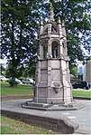 | |||
| 57 Southesk Street | 56°43′56″N 2°39′17″W | Category C(S) | 22574 | | |||
| 19 Swan Street/1 Clerk Street Angus Steak House | 56°43′57″N 2°39′34″W | Category C(S) | 22582 | | |||
| 8-12 Swan Street (Even Numbers) | 56°43′56″N 2°39′35″W | Category B | 22584 | | |||
| 6 Airlie Street | 56°43′58″N 2°39′53″W | Category B | 22411 | | |||
| Brechin Public Park Drinking Fountain | 56°44′09″N 2°39′03″W | Category B | 22420 | | |||
| 7 Castle Street | 56°43′52″N 2°39′50″W | Category C(S) | 22423 | | |||
| 13,15,17,19 Castle Street | 56°43′51″N 2°39′54″W | Category C(S) | 22425 | | |||
| Garden House At Bearhill, 24 Castle Street | 56°43′56″N 2°39′59″W | Category C(S) | 22434 | | |||
| Walls, Channonry Wynd | 56°43′50″N 2°39′49″W | Category C(S) | 22436 | | |||
| Hall, Church Lane | 56°43′52″N 2°39′40″W | Category C(S) | 22442 | | |||
| 20, 22 Church Street | 56°43′54″N 2°39′42″W | Category C(S) | 22458 | | |||
| East Mill, East Mill Road North Section Of Mill | 56°43′31″N 2°38′34″W | Category B | 22468 | | |||
| 39, 41 High Street | 56°43′53″N 2°39′34″W | Category B | 22479 | | |||
| Kintrockat House | 56°43′19″N 2°42′25″W | Category A | 5011 | | |||
| Ardovie House, Sundial | 56°41′53″N 2°39′59″W | Category B | 5017 | | |||
| Arrat Mill, Old Cornmill | 56°43′00″N 2°35′09″W | Category C(S) | 5025 | | |||
| Brechin Castle Icehouse (Now Blocked Up) | 56°43′44″N 2°39′37″W | Category C(S) | 5032 | | |||
| Brechin Castle Fountain | 56°43′37″N 2°40′01″W | Category C(S) | 5037 | | |||
| Little Keithock Dovecot | 56°45′13″N 2°38′41″W | Category B | 5054 | | |||
| 1 Channonry Wynd | 56°43′51″N 2°39′45″W | Category C(S) | 44202 | | |||
| 111, 113, 115 High Street | 56°43′49″N 2°39′27″W | Category B | 22489 | | |||
| 10, 12, 14 High Street | 56°43′55″N 2°39′38″W | Category B | 22491 | | |||
| 22, 24 High Street | 56°43′54″N 2°39′37″W | Category B | 22493 | | |||
| 26, 26A High Street | 56°43′54″N 2°39′37″W | Category B | 22494 | | |||
| 66 High Street | 56°43′51″N 2°39′33″W | Category B | 22504 | | |||
| 84 Market Street | 56°44′04″N 2°39′38″W | Category C(S) | 22512 | | |||
| Den Burn Works Montrose Street And Southesk Street (Front Portions Only) | 56°43′47″N 2°39′12″W | Category B | 22513 | 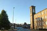 | |||
| Rosehill 15 North Latch Road | 56°44′00″N 2°40′19″W | Category B | 22514 | | |||
| 9, 11 Panmure Street | 56°43′59″N 2°39′29″W | Category C(S) | 22518 | | |||
| 19 Panmure Street | 56°44′00″N 2°39′28″W | Category C(S) | 22520 | | |||
| Baptist Church (Formerly West And St Columba's Parish Church) And Halls, Panmure Street/Southesk Street | 56°44′01″N 2°39′27″W | Category A | 22522 | 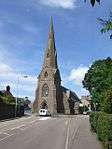 | |||
| 32, 34 Panmure Street | 56°44′00″N 2°39′25″W | Category C(S) | 22532 | | |||
| Maisondieu Primary School St Andrew Street Original Part Only | 56°44′00″N 2°39′43″W | Category C(S) | 22552 | | |||
| 1,2,3,4,5 St Ninian's Place Southesk Street | 56°43′53″N 2°39′14″W | Category C(S) | 22563 | | |||
| Gardner Memorial Church, St Ninian's Square And Damacre Road Including Church Halls And Vestries | 56°43′54″N 2°39′16″W | Category A | 22568 | 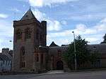 | |||
| Bridge To Cemetery Off Southesk Street | 56°44′02″N 2°39′23″W | Category B | 22576 | | |||
| Gateway To Cemetery Off Southesk Street | 56°44′02″N 2°39′21″W | Category B | 22577 | | |||
| 7,9,11,13 Swan Street City Hall Buildings | 56°43′57″N 2°39′35″W | Category C(S) | 22581 | | |||
| A Christie's Premises (Former Drill Hall) Bank Street | 56°43′57″N 2°39′23″W | Category C(S) | 22414 | | |||
| Brechin Public Park Bandstand | 56°44′10″N 2°39′04″W | Category B | 22419 | | |||
| Lodge, Entrance Gateway And Flanking Walls To Brechin Castle 25 Castle Street At St Michael's Mount | 56°43′50″N 2°40′00″W | Category B | 22427 | | |||
| 5, 7, 9 Church Street | 56°43′53″N 2°39′38″W | Category B | 22443 | | |||
| 19, 21 Church Street And 1 Church Lane | 56°43′53″N 2°39′40″W | Category B | 22446 |  | |||
| 23 Church Street And Wall Church Lane | 56°43′53″N 2°39′41″W | Category B | 22447 | | |||
| 3 Clerk Street | 56°43′59″N 2°39′34″W | Category C(S) | 22462 | | |||
| Jolly's Hotel 14 Clerk Street | 56°44′00″N 2°39′33″W | Category C(S) | 22464 | | |||
| Gatepiers At Springfield Cookston Road | 56°44′15″N 2°39′46″W | Category C(S) | 22467 | | |||
| 7, 9 High Street | 56°43′55″N 2°39′36″W | Category B | 22472 | | |||
| 17, 19 High Street | 56°43′54″N 2°39′36″W | Category B | 22474 | | |||
| 43, 45 High Street | 56°43′53″N 2°39′34″W | Category B | 22480 | | |||
| Auldbar School And Gates To Auldbar Castle | 56°42′22″N 2°41′40″W | Category B | 5015 |  | |||
| Ardovie House | 56°41′54″N 2°39′57″W | Category A | 5016 | | |||
| Arrat Mill House | 56°43′00″N 2°35′02″W | Category C(S) | 5026 | | |||
| Railway Overbridge Near Windyedge Farm | 56°43′24″N 2°36′16″W | Category C(S) | 5028 |  | |||
| Brechin Castle Old Lodge | 56°43′48″N 2°40′07″W | Category B | 5034 |  | |||
| Brechin Castle Walled Garden | 56°43′36″N 2°40′04″W | Category B | 5036 | 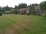 | |||
| Brechin Castle Old Sundial | 56°43′36″N 2°40′04″W | Category B | 5038 | | |||
| Dalgety Farmhouse | 56°43′22″N 2°38′20″W | Category B | 5044 | | |||
| Ornamental Bridge Over Keithock Burn, N. Of Packbridge | 56°45′41″N 2°39′09″W | Category C(S) | 5051 | | |||
| Keithock House Stables, Farmhouse And Steading | 56°45′42″N 2°39′07″W | Category B | 5055 | | |||
| 109 High Street | 56°43′49″N 2°39′27″W | Category C(S) | 22488 | | |||
| 38, 40 High Street | 56°43′53″N 2°39′36″W | Category B | 22497 | | |||
| 46 High Street | 56°43′52″N 2°39′35″W | Category B | 22499 | | |||
| 62 High Street | 56°43′51″N 2°39′33″W | Category C(S) | 22503 | | |||
| 76, 78 High Street | 56°43′50″N 2°39′32″W | Category C(S) | 22506 | | |||
| Glencairn Infirmary Street | 56°43′58″N 2°39′11″W | Category C(S) | 22507 | | |||
| Maison Dieu Chapel Maisondieu Lane | 56°43′59″N 2°39′39″W | Category A | 22508 | 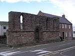 | |||
| Dalhousie Hotel 1, 3 Market Street And 2, 4, 6 St David Street | 56°43′56″N 2°39′38″W | Category B | 22510 | | |||
| 82 Market Street | 56°44′02″N 2°39′38″W | Category B | 22511 | | |||
| Railway Station, Including Former Goods Depot, Park Road | 56°43′54″N 2°39′10″W | Category B | 22536 | 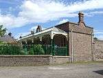 | |||
| 4 Park Road | 56°43′56″N 2°39′05″W | Category C(S) | 22537 | | |||
| 1 Pearse Street/8 Airlie Street | 56°43′58″N 2°39′55″W | Category C(S) | 22541 | | |||
| 6 Pearse Street | 56°44′00″N 2°39′53″W | Category C(S) | 22544 | | |||
| Brechin Bridge Over River South Esk Off River Street | 56°43′24″N 2°38′53″W | Category A | 22549 | 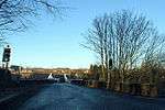 | |||
| 7 St Mary Street | 56°43′54″N 2°39′44″W | Category C(S) | 22562 | | |||
| Sundial St Ninian's Square | 56°43′56″N 2°39′15″W | Category C(S) | 22571 | | |||
| Former Church Of St Ninian (Now Roman Catholic Church) Bank Street | 56°43′56″N 2°39′21″W | Category B | 22413 | | |||
| Jehovah's Witnesses' Hall (Former East R C School) Bank Street | 56°43′57″N 2°39′24″W | Category C(S) | 22415 | | |||
| 32, 34 Bank Street Town Clerk's And Police Offices | 56°43′59″N 2°39′24″W | Category B | 22416 | | |||
| 1 Castle Street | 56°43′53″N 2°39′47″W | Category C(S) | 22421 | | |||
| 9 Castle Street (Including Garden Wall And Gateway) | 56°43′52″N 2°39′52″W | Category C(S) | 22424 | | |||
| Bearhill Lodge 22 Castle Street | 56°43′51″N 2°39′59″W | Category B | 22432 | | |||
| 5 Channonry Wynd | 56°43′50″N 2°39′47″W | Category C(S) | 22435 | | |||
| Round Tower At South West Angle Of Cathedral Church Lane | 56°43′51″N 2°39′41″W | Category A | 22440 | 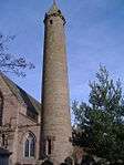 | |||
| Brechin Mechanics' Institute, Church Street And St Mary Street | 56°43′54″N 2°39′45″W | Category B | 22459 | | |||
| 1, 3 High Street And 2, 4 Swan Street | 56°43′56″N 2°39′37″W | Category B | 22470 | | |||
| 11, 13 High Street | 56°43′55″N 2°39′36″W | Category B | 22473 | | |||
| 33, 35, 37 High Street | 56°43′53″N 2°39′35″W | Category B | 22478 | | |||
| Wardend Of Keithock | 56°46′02″N 2°38′41″W | Category B | 5006 | | |||
| Murlingden House West Gates And Lodge | 56°45′07″N 2°40′16″W | Category C(S) | 5010 | | |||
| Ardovie House, Walled Garden | 56°41′53″N 2°40′00″W | Category C(S) | 5018 | | |||
| Temple Near Bank Of South Esk, Kinnaird | 56°42′54″N 2°37′06″W | Category B | 5021 | | |||
| Balbirnie Mills | 56°43′00″N 2°36′10″W | Category B | 5022 | 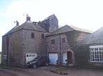 | |||
| Arrat, Farmhouse | 56°43′12″N 2°35′32″W | Category C(S) | 5024 | | |||
| Brechin Castle Detached Columns | 56°43′44″N 2°39′37″W | Category C(S) | 5040 | | |||
| Stannochy Bridge | 56°43′19″N 2°40′54″W | Category A | 5042 | 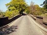 | |||
| East Tollhouse, Montrose Road, Brechin | 56°43′39″N 2°38′21″W | Category C(S) | 5045 | | |||
| Leuchland Farmhouse | 56°43′42″N 2°37′04″W | Category B | 94 | | |||
| 91-93 High Street | 56°43′50″N 2°39′29″W | Category C(S) | 22486 | | |||
| Andover (Originally Tenements) School, Nursery Lane | 56°43′39″N 2°39′03″W | Category B | 22517 | | |||
| 18, 20 Panmure Street | 56°43′58″N 2°39′28″W | Category C(S) | 22527 | | |||
| 28 Panmure Street | 56°43′59″N 2°39′26″W | Category B | 22530 | | |||
| 7, 9, 11, 13 Park Road | 56°43′54″N 2°39′12″W | Category C(S) | 22533 | | |||
| Lodge At Viewbank Park Road | 56°43′56″N 2°38′41″W | Category C(S) | 22540 | | |||
| Pearse Croft 8 Pearse Street | 56°44′00″N 2°39′54″W | Category C(S) | 22545 | | |||
| St Andrew's Episcopal Church, Argyll Street And St Andrew Street | 56°44′00″N 2°39′46″W | Category B | 22551 | | |||
| 22 St David Street | 56°43′56″N 2°39′40″W | Category C(S) | 22557 | | |||
| Lodge At Cemetery Off Southesk Street | 56°44′02″N 2°39′21″W | Category C(S) | 22578 | | |||
| 2 Airlie Street | 56°43′56″N 2°39′45″W | Category C(S) | 22409 | | |||
| Balgownie 4 Airlie Street/1 Argyle Street | 56°43′57″N 2°39′49″W | Category C(S) | 22410 | | |||
| The Mary Acre 11 Argyle Street | 56°44′02″N 2°39′53″W | Category B | 22412 | | |||
| Offices At 18 Castle Street | 56°43′53″N 2°39′54″W | Category C(S) | 22431 | | |||
| 4 Church Street | 56°43′54″N 2°39′38″W | Category C(S) | 22455 | | |||
| Exchange Bar 8 Church Street | 56°43′54″N 2°39′38″W | Category C(S) | 22456 | | |||
| 18 Church Street | 56°43′54″N 2°39′41″W | Category C(S) | 22457 | | |||
| 51, 53, 55 High Street | 56°43′52″N 2°39′33″W | Category C(S) | 22482 | | |||
| 57 High Street | 56°43′52″N 2°39′33″W | Category C(S) | 22483 | | |||
| North Lodge, Kinnaird | 56°43′04″N 2°37′42″W | Category B | 5020 | | |||
| Brechin Castle Image Bridge Over River South Esk | 56°43′38″N 2°39′40″W | Category B | 5035 | | |||
| Brechin Castle New Sundial | 56°43′36″N 2°40′08″W | Category C(S) | 5039 | | |||
| Brechin Castle Avenue Old Gate Piers | 56°43′48″N 2°40′07″W | Category B | 5041 | | |||
| Keithock House, Laundry | 56°45′40″N 2°39′04″W | Category C(S) | 5056 | | |||
| 4, 6, 8 High Street | 56°43′55″N 2°39′38″W | Category C(S) | 22490 | | |||
| Old Town Hall 28 High Street And 2 Church Street | 56°43′54″N 2°39′37″W | Category B | 22495 | 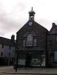 | |||
| 42, 44 High Street | 56°43′52″N 2°39′35″W | Category B | 22498 | | |||
| Lodge At Rosehill 15 North Latch Road | 56°44′01″N 2°40′20″W | Category C(S) | 22515 | | |||
| 8, 10 Panmure Street And 2,4,6 Martin's Lane | 56°43′58″N 2°39′30″W | Category C(S) | 22524 | | |||
| Viewbank, Park Road | 56°43′55″N 2°38′37″W | Category B | 22538 | | |||
| Haybarn At Viewbank Park Road | 56°43′57″N 2°38′38″W | Category C(S) | 22539 | | |||
| Grove House, 22 St Andrew Street | 56°44′04″N 2°39′43″W | Category C(S) | 22553 | | |||
| 24,26,28 St David Street | 56°43′56″N 2°39′41″W | Category C(S) | 22558 | | |||
| 10,11,12,13 St Ninian's Place | 56°43′53″N 2°39′13″W | Category C(S) | 22565 | | |||
| Public Library St Ninian's Square | 56°43′57″N 2°39′14″W | Category B | 22570 |  | |||
| 5 Swan Street | 56°43′57″N 2°39′36″W | Category B | 22580 | | |||
| Vanes Park Airlie Street | 56°43′59″N 2°40′07″W | Category C(S) | 22408 | | |||
| Brechin Cathedral Church Lane | 56°43′51″N 2°39′41″W | Category A | 22439 | 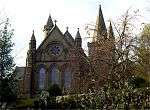 | |||
| 27 Church Street | 56°43′53″N 2°39′42″W | Category C(S) | 22449 | | |||
| 41 Church Street | 56°43′53″N 2°39′46″W | Category B | 22453 | | |||
| Northern Hotel 2, 4 Clerk Street And 1, 3, 5, 7 Panmure Street | 56°43′59″N 2°39′32″W | Category B | 22463 | | |||
| 5 High Street | 56°43′55″N 2°39′36″W | Category B | 22471 | | |||
| 49 High Street, Former Co-Operative Building | 56°43′52″N 2°39′34″W | Category C(S) | 22481 | | |||
| Balbirniemills House And Adjoining Cottage | 56°43′01″N 2°36′13″W | Category C(S) | 5023 | | |||
| Brechin Castle | 56°43′44″N 2°39′32″W | Category A | 5030 | 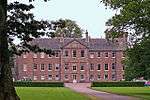 | |||
| Burghill, Farmhouse | 56°43′16″N 2°39′40″W | Category B | 5043 | | |||
| Little Keithock Bridge Over Keithock Burn | 56°45′12″N 2°38′41″W | Category C(S) | 5049 | | |||
| Old Pack Bridge Over Keithock Burn Between Little Keithock And Keithock House | 56°45′28″N 2°39′03″W | Category B | 5050 | | |||
| 97, 99 High Street | 56°43′49″N 2°39′29″W | Category C(S) | 22487 | | |||
| 30 High Street | 56°43′53″N 2°39′37″W | Category C(S) | 22496 | | |||
| 56, 58, 60 High Street | 56°43′51″N 2°39′34″W | Category C(S) | 22502 | | |||
| 4, 6 Panmure Street Clydesdale Bank | 56°43′57″N 2°39′30″W | Category C(S) | 22523 | | |||
| 22, 24 Panmure Street | 56°43′59″N 2°39′28″W | Category C(S) | 22528 | | |||
| 20 Pearse Street | 56°44′03″N 2°39′55″W | Category C(S) | 22548 | | |||
| 51 Southesk Street | 56°43′55″N 2°39′17″W | Category C(S) | 22572 | | |||
| 55 Southesk Street | 56°43′56″N 2°39′17″W | Category C(S) | 22573 | | |||
| Glencadam House Off Trinity Road | 56°44′17″N 2°39′10″W | Category B | 22587 | | |||
| City Royal Bar 26 City Road | 56°43′50″N 2°39′24″W | Category C(S) | 22460 | | |||
| 22, 24 Clerk Street Post Office | 56°44′01″N 2°39′33″W | Category C(S) | 22465 | | |||
| East Mill, East Mill Road South Section Of Mill | 56°43′31″N 2°38′34″W | Category C(S) | 22469 | | |||
| 29, 31 High Street | 56°43′54″N 2°39′35″W | Category B | 22477 | | |||
| Railway Under-Bridge Near Leuchland | 56°43′36″N 2°37′31″W | Category C(S) | 5046 | | |||
| Gatepiers At Rosehill 15 North Latch Road | 56°43′59″N 2°40′02″W | Category C(S) | 22516 | | |||
| 26 Panmure Street | 56°43′59″N 2°39′27″W | Category C(S) | 22529 | | |||
| Pearsemount, 3 Pearse Street | 56°44′00″N 2°39′56″W | Category B | 22542 | | |||
| 16 Pearce Street | 56°44′01″N 2°39′54″W | Category C(S) | 22546 | | |||
| Townhead Primary School St Andrew Street | 56°44′05″N 2°39′44″W | Category C(S) | 22554 | | |||
| 6 Swan Street | 56°43′56″N 2°39′36″W | Category C(S) | 22583 | | |||
| Manse Offices Bishop's Close | 56°43′52″N 2°39′39″W | Category C(S) | 22418 | | |||
| 5 Castle Street | 56°43′52″N 2°39′50″W | Category C(S) | 22422 | | |||
| 18 Castle Street | 56°43′53″N 2°39′54″W | Category C(S) | 22430 | | |||
| Bearhill 24 Castle Street | 56°43′54″N 2°39′57″W | Category B | 22433 | | |||
| Shed-Garage Channonry Wynd | 56°43′50″N 2°39′49″W | Category C(S) | 22437 | | |||
| 'Castle View' 17 Church Street | 56°43′53″N 2°39′39″W | Category B | 22445 | | |||
| 25 Church Street And Wall Church Lane | 56°43′53″N 2°39′42″W | Category B | 22448 | | |||
| Springfield Cookston Road | 56°44′14″N 2°39′50″W | Category B | 22466 | | |||
| 21, 23 High Street | 56°43′54″N 2°39′36″W | Category C(S) | 22475 | | |||
| 25, 27 High Street | 56°43′54″N 2°39′35″W | Category A | 22476 | | |||
| 61, 61A High Street | 56°43′52″N 2°39′32″W | Category B | 22484 | | |||
| 85, 87 High Street | 56°43′50″N 2°39′29″W | Category C(S) | 22485 | | |||
| Murlingden House | 56°45′16″N 2°40′13″W | Category B | 5007 | | |||
| St. Ann's | 56°43′42″N 2°42′29″W | Category B | 5008 | | |||
| Murlingden House Main Gates | 56°45′06″N 2°40′16″W | Category C(S) | 5009 | | |||
| Kintrockat Lodge And Gates | 56°43′39″N 2°42′14″W | Category C(S) | 5012 | | |||
| Auldbar Castle. Bridge At Junction Of East Lodge And School Drives | 56°43′02″N 2°41′25″W | Category C(S) | 5013 | | |||
| Brechin Reservoir Commemorative Pedestal | 56°44′52″N 2°38′55″W | Category B | 5029 | | |||
| Brechin Castle Stableblock | 56°43′48″N 2°39′39″W | Category B | 5033 | | |||
| Keithock House | 56°45′38″N 2°39′00″W | Category B | 5053 | | |||
| Keithock House, Bridge Over Keithock Burn | 56°45′36″N 2°39′02″W | Category B | 5005 | | |||
| Mains Of Ardovie, Farmhouse | 56°41′46″N 2°40′35″W | Category B | 93 | |
Key
The scheme for classifying buildings in Scotland is:
- Category A: "buildings of national or international importance, either architectural or historic; or fine, little-altered examples of some particular period, style or building type."[1]
- Category B: "buildings of regional or more than local importance; or major examples of some particular period, style or building type, which may have been altered."[1]
- Category C: "buildings of local importance; lesser examples of any period, style, or building type, as originally constructed or moderately altered; and simple traditional buildings which group well with other listed buildings."[1]
In March 2016 there were 47,288 listed buildings in Scotland. Of these, 8% were Category A, and 50% were Category B, with the remaining 42% being Category C.[2]
gollark: *ToDs
gollark: *is annoyed at lack of accurate timers*
gollark: Now to spend ages working out the ToD!
gollark: I'll just go incubate it now.
gollark: 12V, 5U, 2C.
See also
Notes
- Sometimes known as OSGB36, the grid reference (where provided) is based on the British national grid reference system used by the Ordnance Survey.
• "Guide to National Grid". Ordnance Survey. Retrieved 2007-12-12.
• "Get-a-map". Ordnance Survey. Retrieved 2007-12-17. - Historic Environment Scotland assign a unique alphanumeric identifier to each designated site in Scotland, for listed buildings this always begins with "LB", for example "LB12345".
References
- All entries, addresses and coordinates are based on data from Historic Scotland. This data falls under the Open Government Licence
- "What is Listing?". Historic Environment Scotland. Retrieved 29 May 2018.
- Scotland's Historic Environment Audit 2016 (PDF). Historic Environment Scotland and the Built Environment Forum Scotland. pp. 15–16. Retrieved 29 May 2018.
This article is issued from Wikipedia. The text is licensed under Creative Commons - Attribution - Sharealike. Additional terms may apply for the media files.