List of listed buildings in Boyndie, Aberdeenshire
List
| Name | Location | Date Listed | Grid Ref. [note 1] | Geo-coordinates | Notes | LB Number [note 2] | Image |
|---|---|---|---|---|---|---|---|
| Whitehills, 7 Knock Street | 57°40′42″N 2°34′45″W | Category C(S) | 3229 |  | |||
| Inverboyndie Bridge Over The Burn Of Boyndie | 57°40′06″N 2°33′28″W | Category B | 3236 | | |||
| Inverboyndie St Brandon's Church (Old Parish Church Of Scotland) And Burial Ground | 57°40′10″N 2°33′38″W | Category B | 3237 | | |||
| Whitehills, 12 West End | 57°40′39″N 2°35′07″W | Category C(S) | 3167 | | |||
| Whitehills, 15 Knock Street | 57°40′42″N 2°34′40″W | Category C(S) | 3194 | | |||
| Whitehills, 6 Knock Street | 57°40′41″N 2°34′44″W | Category C(S) | 3197 | | |||
| Whitehills, 22 Knock Street | 57°40′42″N 2°34′37″W | Category C(S) | 3203 | | |||
| Whitehills, 1 Low Shore | 57°40′38″N 2°35′05″W | Category C(S) | 3206 | | |||
| Whitehills, 4 Low Shore | 57°40′38″N 2°35′03″W | Category B | 3209 | | |||
| Whitehills, 8 Low Shore | 57°40′38″N 2°35′01″W | Category C(S) | 3213 | | |||
| Whitehills, 8 Boyne Street | 57°40′38″N 2°35′04″W | Category C(S) | 3222 | | |||
| Whitehills, Chapel Street, Methodist Chapel, Enclosing Walls And Gatepiers | 57°40′38″N 2°34′52″W | Category B | 3223 | | |||
| Whitehills, 13 Knock Street, Corein Cott | 57°40′42″N 2°34′41″W | Category C(S) | 3232 | | |||
| Mill Of Boyndie Farmhouse | 57°39′56″N 2°33′48″W | Category B | 3242 | | |||
| Whitehills, Seafield Street, Trinity Church (Church Of Scotland) | 57°40′32″N 2°34′48″W | Category B | 3165 | | |||
| Whitehills, 14 West End, Honey Cottage | 57°40′38″N 2°35′06″W | Category C(S) | 3169 | | |||
| Whitehills, 11 Low Shore | 57°40′38″N 2°34′59″W | Category C(S) | 3175 | | |||
| Whitehills, 13, 14 Low Shore, Cuil-Na-Mara | 57°40′39″N 2°34′59″W | Category C(S) | 3176 | | |||
| Whitehills, 25 Low Shore | 57°40′39″N 2°34′56″W | Category B | 3185 | | |||
| Whitehills, 32 Low Shore | 57°40′39″N 2°34′54″W | Category C(S) | 3192 | | |||
| Whitehills, 33 Low Shore | 57°40′39″N 2°34′54″W | Category C(S) | 3193 | | |||
| Whitehills, 8 Knock Street | 57°40′41″N 2°34′43″W | Category C(S) | 3198 | | |||
| Whitehills, 18 Knock Street | 57°40′42″N 2°34′39″W | Category C(S) | 3202 | | |||
| Whitehills, 3 Low Shore | 57°40′38″N 2°35′04″W | Category C(S) | 3208 | | |||
| Boyndie Airfield, Operations Block | 57°39′31″N 2°37′56″W | Category B | 49836 | | |||
| Whitehills, 6 Boyne Street | 57°40′38″N 2°35′05″W | Category C(S) | 3221 | | |||
| Lintmill Bridge Over The Burn Of Boyne | 57°40′21″N 2°39′37″W | Category C(S) | 3240 | | |||
| Mains Of Baldavie House | 57°38′21″N 2°38′11″W | Category B | 3241 | | |||
| Whitehills, 15 Low Shore | 57°40′39″N 2°34′59″W | Category C(S) | 3177 | | |||
| Whitehills, 26 Low Shore | 57°40′39″N 2°34′55″W | Category C(S) | 3186 | | |||
| Whitehills 10 And 10A Knock Street, Knock House And Garden Walls | 57°40′41″N 2°34′42″W | Category B | 3199 | | |||
| Whitehills, Low Shore/ Seafield Street, Seafield Estate Girnal/Warehouse | 57°40′43″N 2°34′47″W | Category B | 3205 | | |||
| Whitehills, 3 Boyne Street | 57°40′37″N 2°35′06″W | Category C(S) | 3216 | | |||
| Whitehills, 4 Boyne Street | 57°40′37″N 2°35′06″W | Category C(S) | 3217 | | |||
| Whitehills, Chapel Street, Seafield Arms Hotel, Garden Walls And Gatepiers | 57°40′37″N 2°34′51″W | Category B | 3224 | | |||
| Whitehills, 34 Low Shore | 57°40′40″N 2°34′55″W | Category C(S) | 3163 | | |||
| Whitehills, 22 Seafield Street, Greystones And Garden Walls | 57°40′38″N 2°34′48″W | Category B | 3166 | | |||
| Whitehills, 19 Low Shore | 57°40′39″N 2°34′58″W | Category C(S) | 3181 | | |||
| Whitehills, 17 Knock Street | 57°40′43″N 2°34′39″W | Category C(S) | 3195 | | |||
| Whitehills, 16 Knock Street | 57°40′42″N 2°34′39″W | Category C(S) | 3201 | | |||
| Whitehills, 10 Boyne Street | 57°40′37″N 2°35′03″W | Category C(S) | 3219 | | |||
| Whitehills, 1 Knock Street | 57°40′41″N 2°34′47″W | Category B | 3226 | | |||
| Whitehills, 3 Knock Street | 57°40′42″N 2°34′46″W | Category C(S) | 3227 | | |||
| Whitehills, 23 Ogilvie Street | 57°40′39″N 2°34′54″W | Category C(S) | 3164 | | |||
| Whitehills, 9 Low Shore | 57°40′38″N 2°35′00″W | Category B | 3173 | | |||
| Whitehills, 10 Low Shore, Drumfergue | 57°40′38″N 2°35′00″W | Category C(S) | 3174 | | |||
| Whitehills, 18 Low Shore | 57°40′38″N 2°34′57″W | Category C(S) | 3180 | | |||
| Whitehills, 24 Low Shore | 57°40′39″N 2°34′56″W | Category C(S) | 3184 | | |||
| Whitehills, 31 Low Shore | 57°40′39″N 2°34′55″W | Category C(S) | 3191 | | |||
| Whitehills, 19 Knock Street | 57°40′43″N 2°34′38″W | Category B | 3196 | | |||
| Whitehills, 24 Knock Street | 57°40′42″N 2°34′36″W | Category C(S) | 3204 | | |||
| Whitehills, 2 Low Shore | 57°40′38″N 2°35′04″W | Category C(S) | 3207 | | |||
| Whitehills, 5 Low Shore And Store | 57°40′38″N 2°34′59″W | Category C(S) | 3210 | | |||
| Scotsmill Mill And Former Steading | 57°40′37″N 2°39′18″W | Category B | 3215 | | |||
| Whitehills, 11 Boyne Street | 57°40′37″N 2°35′03″W | Category C(S) | 3220 | | |||
| Whitehills, Harbour Place, Lifeboat House And Slipway | 57°40′47″N 2°34′43″W | Category B | 3225 | | |||
| Whitehills, 9 And 9A Knock Street | 57°40′42″N 2°34′44″W | Category C(S) | 3230 | | |||
| Whitehills, 11 Knock Street, Elaness | 57°40′42″N 2°34′43″W | Category C(S) | 3231 | | |||
| Boyndie Parish Church (Church Of Scotland), Former Beadle's Cottage And Steading | 57°39′46″N 2°36′06″W | Category B | 3234 | | |||
| Ladysbridge Hospital, Troup, Administration And Moor Newton Blocks | 57°39′46″N 2°35′19″W | Category B | 3238 | 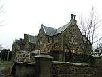 | |||
| Whitehills, 13 West End | 57°40′38″N 2°35′07″W | Category C(S) | 3168 | | |||
| Whitehills, 17 West End | 57°40′38″N 2°35′07″W | Category C(S) | 3171 | | |||
| Whitehills, 16 Low Shore | 57°40′38″N 2°34′58″W | Category C(S) | 3178 | | |||
| Whitehills, 21 Low Shore | 57°40′39″N 2°34′58″W | Category B | 3182 | | |||
| Whitehills, 28 Low Shore | 57°40′40″N 2°34′55″W | Category C(S) | 3188 | | |||
| Whitehills, 6 Low Shore | 57°40′38″N 2°35′02″W | Category C(S) | 3211 | | |||
| Scotsmill Bridge Over The Burn Of Boyne | 57°40′37″N 2°39′19″W | Category B | 3214 | | |||
| Whitehills, 7 Boyne Street | 57°40′37″N 2°35′04″W | Category C(S) | 3218 | | |||
| Whitehills, 5 Knock Street | 57°40′42″N 2°34′45″W | Category C(S) | 3228 | | |||
| Boyndie Church Of Scotland Manse | 57°39′48″N 2°36′02″W | Category B | 3235 | | |||
| Lintmill Of Boyne, Old Lintmill And Garden Wall At South | 57°40′11″N 2°39′34″W | Category C(S) | 3239 | | |||
| Whitehills, 27 Low Shore | 57°40′39″N 2°34′56″W | Category C(S) | 3187 | | |||
| Whitehills, 29 Low Shore | 57°40′40″N 2°34′55″W | Category C(S) | 3189 | | |||
| Whitehills, 24A Low Shore | 57°40′39″N 2°34′56″W | Category C(S) | 40 | | |||
| Whitehills, 7 Low Shore | 57°40′38″N 2°35′02″W | Category C(S) | 3212 | | |||
| 'Art Caput', Boyndie | 57°39′48″N 2°36′09″W | Category B | 3233 | | |||
| Whitehills, 15 West End | 57°40′38″N 2°35′07″W | Category C(S) | 3170 | | |||
| Whitehills, 18 West End | 57°40′38″N 2°35′06″W | Category C(S) | 3172 | | |||
| Whitehills, 17 Low Shore Stormcrest | 57°40′39″N 2°34′58″W | Category B | 3179 | | |||
| Whitehills, 22 Low Shore | 57°40′38″N 2°34′56″W | Category C(S) | 3183 | | |||
| Whitehills, 30 Low Shore | 57°40′40″N 2°34′55″W | Category C(S) | 3190 | | |||
| Whitehills, 14 Knock Street | 57°40′42″N 2°34′40″W | Category C(S) | 3200 | | |||
| Boyndie Airfield, Control Tower | 57°39′59″N 2°38′01″W | Category B | 49835 | |
Key
The scheme for classifying buildings in Scotland is:
- Category A: "buildings of national or international importance, either architectural or historic; or fine, little-altered examples of some particular period, style or building type."[1]
- Category B: "buildings of regional or more than local importance; or major examples of some particular period, style or building type, which may have been altered."[1]
- Category C: "buildings of local importance; lesser examples of any period, style, or building type, as originally constructed or moderately altered; and simple traditional buildings which group well with other listed buildings."[1]
In March 2016 there were 47,288 listed buildings in Scotland. Of these, 8% were Category A, and 50% were Category B, with the remaining 42% being Category C.[2]
gollark: I should see if it runs PotatOS Hypercycle™.
gollark: Just very slowly.
gollark: I think it actually works somehow.
gollark: The best test of a CC emulator is whether it can run PotatOS. It actually caused several segfaults and other bugs in CraftOS-PC somehow.
gollark: The only difference is that CC is Lua 5.1ish plus extra features while OC is 5.2/5.3.
Notes
- Sometimes known as OSGB36, the grid reference (where provided) is based on the British national grid reference system used by the Ordnance Survey.
• "Guide to National Grid". Ordnance Survey. Retrieved 2007-12-12.
• "Get-a-map". Ordnance Survey. Retrieved 2007-12-17. - Historic Environment Scotland assign a unique alphanumeric identifier to each designated site in Scotland, for listed buildings this always begins with "LB", for example "LB12345".
References
- All entries, addresses and coordinates are based on data from Historic Scotland. This data falls under the Open Government Licence
- "What is Listing?". Historic Environment Scotland. Retrieved 29 May 2018.
- Scotland's Historic Environment Audit 2016 (PDF). Historic Environment Scotland and the Built Environment Forum Scotland. pp. 15–16. Retrieved 29 May 2018.
This article is issued from Wikipedia. The text is licensed under Creative Commons - Attribution - Sharealike. Additional terms may apply for the media files.