List of listed buildings in Borthwick, Midlothian
List
| Name | Location | Date Listed | Grid Ref. [note 1] | Geo-coordinates | Notes | LB Number [note 2] | Image |
|---|---|---|---|---|---|---|---|
| Arniston Policies, Sunken Garden, Vehicular Bridge Over Purvies Hill Burn | 55°49′13″N 3°04′35″W | Category B | 45147 |  | |||
| Easter Middleton Farm House Including Gatepiers, Boundary Walls And Walled Garden | 55°48′45″N 3°01′11″W | Category B | 45156 | | |||
| Gorebridge, 25 Powdermill Brae, Including Railings | 55°50′18″N 3°02′44″W | Category C(S) | 45167 | | |||
| Harvieston House Walled Garden | 55°49′52″N 3°02′23″W | Category C(S) | 45177 | | |||
| Newlandburn Lodge | 55°51′09″N 3°00′47″W | Category C(S) | 45184 | | |||
| Torcraik House | 55°49′21″N 3°01′10″W | Category C(S) | 45186 | | |||
| Arniston Policies, 1-5 (Inclusive Nos) Arniston Home Farm Cottages | 55°49′27″N 3°04′13″W | Category C(S) | 45129 | | |||
| Carlyle Lodge (Formerly Castlelaw Lodge), Arniston Policies, Including Gate, Gatepiers And Boundary Wall | 55°49′31″N 3°02′14″W | Category C(S) | 45132 | | |||
| Arniston Policies, Rustic Bridge No 6 Over River South Esk | 55°49′25″N 3°05′04″W | Category B | 45140 | | |||
| Currie House, Walled Garden Including Sundial | 55°49′37″N 3°00′20″W | Category B | 6364 | | |||
| Middleton Hall, Including Gatepiers, Gates, Ha-Ha And Boundary Walls | 55°48′48″N 3°00′36″W | Category A | 806 | | |||
| Arniston House, Including Stable Block, Outbuildings, Orangery, Ha-Ha And Sundial | 55°49′27″N 3°04′43″W | Category A | 808 | 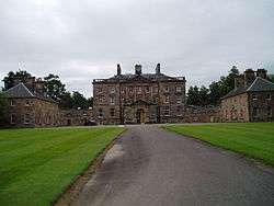 | |||
| Ford Village, The Mill House, Including Outbuildings And Boundary Wall | 55°52′07″N 2°58′45″W | Category C(S) | 817 | | |||
| Borthwick, Old School House, Boundary Wall And Railings | 55°49′32″N 3°00′36″W | Category C(S) | 45152 | | |||
| 1 And 2 Catcune Farm Cottages | 55°49′43″N 3°01′47″W | Category C(S) | 45154 | | |||
| Gorebridge, 34 Hunterfield Road | 55°50′37″N 3°02′55″W | Category C(S) | 45159 | | |||
| Gorebridge, 32 And 34 Main Street | 55°50′29″N 3°02′53″W | Category C(S) | 45162 | 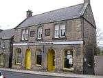 | |||
| Gorebridge, 53 Main Street | 55°50′28″N 3°02′53″W | Category C(S) | 45164 | | |||
| Gorebridge, Porters (The Old Station) | 55°50′24″N 3°02′49″W | Category C(S) | 45165 | | |||
| Harvieston Mains | 55°50′14″N 3°03′15″W | Category C(S) | 45179 | | |||
| 1-4 (Inclusive Nos) Harvieston Mains Cottages | 55°50′16″N 3°03′16″W | Category C(S) | 45180 | | |||
| Arniston Policies, Bridge Over Purvies Hill Burn | 55°49′07″N 3°04′29″W | Category C(S) | 45131 | | |||
| Arniston Policies, Rustic Bridge No 5 Over River South Esk | 55°50′21″N 3°04′10″W | Category B | 45139 | | |||
| 18 Dewartown | 55°52′01″N 2°59′37″W | Category B | 793 | | |||
| Arniston Policies, Ornamental Pillar | 55°49′17″N 3°04′40″W | Category B | 810 | | |||
| Arniston Policies, Grotto | 55°49′16″N 3°04′50″W | Category A | 811 | | |||
| Arniston Policies, North Lodge, And Lion And Elephant Gate, Including Gates And Gatepiers | 55°50′22″N 3°03′39″W | Category A | 814 | | |||
| Ford Village, Vogrie Dower House Including Gates, Gatepiers And Boundary Walls | 55°52′05″N 2°58′51″W | Category B | 816 | | |||
| 11 Newlandrig Including Boundary Wall And Letter Box | 55°51′10″N 3°00′42″W | Category B | 818 | | |||
| Arniston Policies, Sunken Garden, Stone Bench | 55°49′15″N 3°04′34″W | Category B | 45145 | | |||
| Borthwick, Bridge Over Gore Water | 55°49′37″N 3°00′42″W | Category C(S) | 45148 | 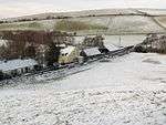 | |||
| Borthwick Manse, Including Gatepiers, Boundary Walls And Outbuildings | 55°49′31″N 3°00′34″W | Category B | 45150 | 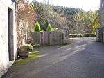 | |||
| Gorebridge, 43 Powdermill Brae Including Railings And Piers | 55°50′15″N 3°02′42″W | Category C(S) | 45170 | | |||
| Harvieston Farm, Outbuildings | 55°49′52″N 3°02′25″W | Category C(S) | 45175 | | |||
| Mountskip Farm House, Including Outbuildings, Gatepiers, Gates And Boundary Walls | 55°50′40″N 3°00′53″W | Category C(S) | 45183 | | |||
| Vogrie House | 55°51′30″N 2°59′26″W | Category A | 799 | 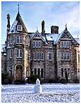 | |||
| Vogrie House Walled Garden | 55°51′26″N 2°59′49″W | Category B | 802 | | |||
| Currie Bridge | 55°49′35″N 3°00′20″W | Category C(S) | 45155 | | |||
| Gorebridge, 20-22 Hunterfield Road, Church, (Struthers Memorial Church) Including Gates, Gatepiers And Boundary Wall | 55°50′35″N 3°02′51″W | Category B | 45157 | | |||
| Gorebridge, Stobsmill House, Including Boundary Wall | 55°50′22″N 3°02′53″W | Category C(S) | 45172 | | |||
| Middleton Mains, The Dugin | 55°48′42″N 2°59′08″W | Category C(S) | 45182 | | |||
| Arniston Policies, Arniston Mains Farmhouse Including Gatepiers And Boundary Walls | 55°49′53″N 3°03′56″W | Category B | 45130 | | |||
| Arniston Policies, East Lodge Including Railings And Piers | 55°49′27″N 3°03′53″W | Category B | 45133 | | |||
| Arniston Policies, Rustic Bridge No 1 Over Purvies Hill Burn | 55°49′15″N 3°04′50″W | Category C(S) | 45135 | | |||
| Arniston Policies, Rustic Bridge No 2 Over Purvies Hill Burn | 55°49′14″N 3°04′54″W | Category C(S) | 45136 | | |||
| Arniston Policies, Rustic Bridge No 3 Over Purvies Hill Burn | 55°49′14″N 3°04′57″W | Category C(S) | 45137 | | |||
| Arniston Policies, Sunken Garden, Ornamental Urn | 55°49′15″N 3°04′35″W | Category C(S) | 45142 | | |||
| Newlandburn House, Including Boundary Walls And Gatepiers | 55°51′10″N 3°00′52″W | Category B | 6645 | | |||
| 50 Dewartown, Oak View | 55°51′58″N 2°59′42″W | Category C(S) | 4908 | | |||
| 9 Dewartown | 55°51′59″N 2°59′39″W | Category B | 790 | | |||
| Vogrie House, West Lodge, Including Railings, Gates And Gatepiers | 55°51′25″N 3°00′02″W | Category B | 800 | | |||
| Vogrie House, Cottage At Walled Garden | 55°51′28″N 2°59′50″W | Category C(S) | 803 | | |||
| Borthwick Castle, Including Outer Walls And Gatehouse | 55°49′36″N 3°00′26″W | Category A | 805 | 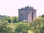 | |||
| Arniston Policies, Garden Urn | 55°49′25″N 3°04′47″W | Category B | 809 | | |||
| Gorebridge, 37 And 39 Powdermill Brae, Bellvue, Including Boundary Wall And Railings | 55°50′16″N 3°02′42″W | Category C(S) | 45168 | | |||
| Gorebridge, Stobsmills House, Walled Garden | 55°50′21″N 3°02′55″W | Category C(S) | 45173 | | |||
| Harvieston House | 55°49′57″N 3°02′27″W | Category C(S) | 45176 | | |||
| Arniston Policies, Arniston Home Farm Farmhouse | 55°49′26″N 3°04′13″W | Category C(S) | 45128 | | |||
| Arniston Policies, Rustic Bridge No 4 Over Purvies Hill Burn | 55°49′13″N 3°05′00″W | Category C(S) | 45138 | | |||
| Currie House, Including Gates, Gatepiers And Boundary Walls | 55°49′40″N 3°00′19″W | Category B | 6363 | | |||
| 54 Dewartown, Rose Cottage | 55°51′57″N 2°59′43″W | Category B | 4909 | | |||
| Vogrie House North Lodge Including Railings, Gates And Gatepiers | 55°51′53″N 2°59′44″W | Category C(S) | 801 | | |||
| Wester Middleton Farm (Old Middleton Inn), Including Boundary Wall And Gatepiers | 55°48′39″N 3°01′05″W | Category C(S) | 807 | | |||
| Arniston Policies, South (Cougar) Gate | 55°49′10″N 3°04′28″W | Category B | 812 | | |||
| Gorebridge, 45A And 45B Main Street, Including Boundary Wall And Railings | 55°50′28″N 3°02′52″W | Category C(S) | 49673 | | |||
| Arniston Policies, Sunken Garden, Rustic Bridge To West Over Purvies Hill Burn | 55°49′16″N 3°04′37″W | Category B | 45144 | | |||
| Gorebridge, 19 And 21 Main Street | 55°50′30″N 3°02′51″W | Category C(S) | 45161 | | |||
| Gorebridge, 36, 38 And 40 Main Street | 55°50′29″N 3°02′53″W | Category C(S) | 45163 | | |||
| Harvieston Lodge, Gates, Gatepiers And Boundary Walls | 55°50′05″N 3°02′52″W | Category B | 45178 | | |||
| Middleton Hall Walled Garden | 55°48′44″N 3°00′36″W | Category B | 45181 | | |||
| Shank Garden, Including Walled Garden And Remains Of Shank House | 55°50′23″N 3°03′55″W | Category C(S) | 45185 | | |||
| Arniston Policies, Summer-House | 55°49′24″N 3°04′37″W | Category C(S) | 45141 | | |||
| Arniston Policies, Sunken Garden, Rustic Bridge To East Over Purvies Hill Burn | 55°49′13″N 3°04′35″W | Category B | 45143 | | |||
| Borthwick Kirk (Church Of Scotland) | 55°49′32″N 3°00′33″W | Category B | 804 | | |||
| Loquhariot Dovecot | 55°50′12″N 3°00′21″W | Category B | 815 | | |||
| Borthwick Churchyard | 55°49′33″N 3°00′33″W | Category C(S) | 45149 | | |||
| Borthwick Manse, Old Stables | 55°49′31″N 3°00′33″W | Category C(S) | 45151 | | |||
| Castleton Farmhouse, Including Gatepiers, Gates And Boundary Walls | 55°48′51″N 3°04′06″W | Category C(S) | 45153 | | |||
| Gorebridge, 13 Hunterfield Road | 55°50′34″N 3°02′53″W | Category C(S) | 45158 | | |||
| Gorebridge, 47 And 49 Powdermill Brae, Gore Cottage, Including Boundary Wall And Railings | 55°50′15″N 3°02′41″W | Category C(S) | 45171 | 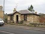 | |||
| Wester Middleton Farm Cartshed And Granary | 55°48′39″N 3°01′06″W | Category C(S) | 45187 | | |||
| Middleton Hall South West Lodge, Wester Middleton | 55°48′37″N 3°00′58″W | Category C(S) | 6619 | | |||
| Vogrie House, Former Stables | 55°51′33″N 2°59′21″W | Category B | 798 | | |||
| Arniston Policies, South Lodge | 55°49′07″N 3°04′28″W | Category C(S) | 813 | | |||
| Arniston Policies, Sunken Garden, Stream Ornament | 55°49′16″N 3°04′42″W | Category C(S) | 45146 | | |||
| Gorebridge, 14 Main Street, Lonach | 55°50′31″N 3°02′52″W | Category C(S) | 45160 | | |||
| Gorebridge Post Office, Main Street | 55°50′28″N 3°02′52″W | Category C(S) | 45166 | 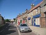 | |||
| Arniston Policies, Old Kennels | 55°49′29″N 3°03′52″W | Category C(S) | 45134 | | |||
| 20 Dewartown, Time Cottage | 55°52′02″N 2°59′37″W | Category C(S) | 794 | | |||
| Currie Mains, Including Ruined Cottage And Boundary Walls | 55°49′29″N 3°00′23″W | Category B | 46172 | |
Key
The scheme for classifying buildings in Scotland is:
- Category A: "buildings of national or international importance, either architectural or historic; or fine, little-altered examples of some particular period, style or building type."[1]
- Category B: "buildings of regional or more than local importance; or major examples of some particular period, style or building type, which may have been altered."[1]
- Category C: "buildings of local importance; lesser examples of any period, style, or building type, as originally constructed or moderately altered; and simple traditional buildings which group well with other listed buildings."[1]
In March 2016 there were 47,288 listed buildings in Scotland. Of these, 8% were Category A, and 50% were Category B, with the remaining 42% being Category C.[2]
gollark: Yes.
gollark: That is not the case.
gollark: No, you're just wrong.
gollark: Radon is another noble gas, yes.
gollark: It's XENON CIRCUMVENTION. Not RADON CIRCUMVENTION. XENON CIRCUMVENTION.
Notes
- Sometimes known as OSGB36, the grid reference (where provided) is based on the British national grid reference system used by the Ordnance Survey.
• "Guide to National Grid". Ordnance Survey. Retrieved 2007-12-12.
• "Get-a-map". Ordnance Survey. Retrieved 2007-12-17. - Historic Environment Scotland assign a unique alphanumeric identifier to each designated site in Scotland, for listed buildings this always begins with "LB", for example "LB12345".
References
- All entries, addresses and coordinates are based on data from Historic Scotland. This data falls under the Open Government Licence
- "What is Listing?". Historic Environment Scotland. Retrieved 29 May 2018.
- Scotland's Historic Environment Audit 2016 (PDF). Historic Environment Scotland and the Built Environment Forum Scotland. pp. 15–16. Retrieved 29 May 2018.
This article is issued from Wikipedia. The text is licensed under Creative Commons - Attribution - Sharealike. Additional terms may apply for the media files.