List of listed buildings in Bonnyrigg And Lasswade, Midlothian
List
| Name | Location | Date Listed | Grid Ref. [note 1] | Geo-coordinates | Notes | LB Number [note 2] | Image |
|---|---|---|---|---|---|---|---|
| Bonnyrigg, 13 And 15 Dundas Street, Including Boundary Walls | 55°52′28″N 3°06′19″W | Category C(S) | 44122 |  | |||
| Lasswade, 5 School Green, Droman House, Including Former Stable Block, Gatepiers And Gates | 55°53′00″N 3°07′02″W | Category B | 44141 | | |||
| Bonnyrigg, Viewbank View, Viewbank House, Summerhouse | 55°52′55″N 3°05′59″W | Category B | 22407 | | |||
| Bonnyrigg, 3 Broomieknowe, Dunraven, Including Gatepiers, Boundary Walls And Outbuilding | 55°52′51″N 3°06′46″W | Category C(S) | 44114 | | |||
| Bonnyrigg, 19 Broomieknowe, Vaila | 55°52′45″N 3°06′50″W | Category B | 44116 | | |||
| Bonnyrigg, Broomieknowe, The Elms Including Outbuilding, Gatepiers And Boundary Walls | 55°52′49″N 3°06′40″W | Category B | 44118 | | |||
| Bonnyrigg, High Street, Bonnyrigg Parish Church | 55°52′37″N 3°06′27″W | Category B | 44127 | 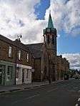 | |||
| Bonnyrigg, Lothian Street, Parish Council Offices, Orchard Centre | 55°52′32″N 3°06′17″W | Category B | 44133 | | |||
| Bonnyrigg, 33 Broomieknowe, The Hill, Garden Pavilion And Summerhouse | 55°52′43″N 3°06′53″W | Category C(S) | 44117 | | |||
| Bonnyrigg, 17 And 19 Dundas Street, Including Boundary Walls | 55°52′27″N 3°06′18″W | Category C(S) | 44123 | | |||
| Bonnyrigg, 11 Elm Row | 55°53′00″N 3°06′46″W | Category C(S) | 44125 | | |||
| Lasswade, School Brae, Lasswade Parish Church Eskside Hall, Including Boundary Wall, Gatepiers And Railings | 55°52′58″N 3°06′57″W | Category C(S) | 44140 | | |||
| Bonnyrigg, 7 Broomieknowe, Strathmore, Including Boundary Wall And Gatepiers | 55°52′50″N 3°06′47″W | Category C(S) | 44115 | | |||
| Bonnyrigg, Dobbies Road, St Leonard Episcopal Church Including Church Hall | 55°52′37″N 3°06′59″W | Category B | 44121 | | |||
| Bonnyrigg, Sherwood Crescent, Cockpen Nursery School Including Boundary Walls And Outbuilding | 55°52′10″N 3°05′42″W | Category B | 44138 | | |||
| Bonnyrigg, Polton Road, Strathesk Church Of Scotland (Lasswade Parish Church) Including Boundary Walls And Railings | 55°52′57″N 3°06′48″W | Category B | 22405 |  | |||
| Bonnyrigg, 10 Hillhead, Olrig, Including Boundary Walls And Gatepiers | 55°52′47″N 3°06′35″W | Category B | 44131 | | |||
| Bonnyrigg, Eldindean Road, Whitehill Villa, Including Gatepiers And Boundary Walls | 55°52′46″N 3°06′26″W | Category B | 44124 | | |||
| Bonnyrigg, 4 Elm Row, Formerly District Council Offices, Including Boundary Walls, Railings And Gates | 55°53′01″N 3°06′47″W | Category B | 44126 | | |||
| Bonnyrigg, Hillhead, Nazareth House | 55°52′58″N 3°06′35″W | Category C(S) | 44128 | | |||
| Bonnyrigg, Lothian Street, Public Library, Orchard Centre | 55°52′31″N 3°06′18″W | Category B | 44134 | | |||
| Bonnyrigg, Hillhead, Nazareth House, Lodge Including Quadrant Walls And Gatepiers | 55°52′56″N 3°06′41″W | Category C(S) | 44129 | | |||
| Bonnyrigg, 7 Hillhead, Viewpark Including Boundary Walls And Gatepiers | 55°52′50″N 3°06′32″W | Category C(S) | 44130 | | |||
| Lasswade, High Street, Brigdgend House | 55°53′00″N 3°06′55″W | Category C(S) | 44139 | | |||
| Lasswade, High Street, Lasswade Bridge, River North Esk | 55°52′59″N 3°06′52″W | Category B | 22406 | | |||
| Bonnyrigg, 12 Broomieknowe, Gordon Bank, Including Boundary Walls, Railings And Gates | 55°52′46″N 3°06′44″W | Category C(S) | 44119 | | |||
| Bonnyrigg, 34 Broomieknowe, Hay Cottage, Including Boundary Walls | 55°53′13″N 3°06′56″W | Category C(S) | 44120 | | |||
| Bonnyrigg, 16 Hillhead, Oakmount Including Boundary Wall And Gatepiers | 55°52′53″N 3°06′45″W | Category B | 44132 | | |||
| Bonnyrigg, 45 Polton Road, Including Boundary Wall And Gatepiers | 55°52′44″N 3°06′57″W | Category B | 44135 | | |||
| Bonnyrigg, Polton Road, Springbank Lodge Including Gateway And Boundary Walls | 55°52′51″N 3°06′52″W | Category C(S) | 44136 | | |||
| Bonnyrigg, Polton Street, Midlothian Teachers' Centre, Formerly Bonnyrigg Infant School | 55°52′21″N 3°06′30″W | Category C(S) | 44137 | |
Key
The scheme for classifying buildings in Scotland is:
- Category A: "buildings of national or international importance, either architectural or historic; or fine, little-altered examples of some particular period, style or building type."[1]
- Category B: "buildings of regional or more than local importance; or major examples of some particular period, style or building type, which may have been altered."[1]
- Category C: "buildings of local importance; lesser examples of any period, style, or building type, as originally constructed or moderately altered; and simple traditional buildings which group well with other listed buildings."[1]
In March 2016 there were 47,288 listed buildings in Scotland. Of these, 8% were Category A, and 50% were Category B, with the remaining 42% being Category C.[2]
gollark: *How* not very large keys?
gollark: General number field sieve time‽
gollark: I mean, you *say* that, but Mathics is a free, open-source general-purpose computer algebra system featuring Mathematica-compatible syntax and functions. It relies on a number of other Python libraries in the Python ecosystem.
gollark: Evidently we should base all our things on zero knowledge proof techniques instead of an admin.
gollark: You're quite clearly here though
Notes
- Sometimes known as OSGB36, the grid reference (where provided) is based on the British national grid reference system used by the Ordnance Survey.
• "Guide to National Grid". Ordnance Survey. Retrieved 2007-12-12.
• "Get-a-map". Ordnance Survey. Retrieved 2007-12-17. - Historic Environment Scotland assign a unique alphanumeric identifier to each designated site in Scotland, for listed buildings this always begins with "LB", for example "LB12345".
References
- All entries, addresses and coordinates are based on data from Historic Scotland. This data falls under the Open Government Licence
- "What is Listing?". Historic Environment Scotland. Retrieved 29 May 2018.
- Scotland's Historic Environment Audit 2016 (PDF). Historic Environment Scotland and the Built Environment Forum Scotland. pp. 15–16. Retrieved 29 May 2018.
This article is issued from Wikipedia. The text is licensed under Creative Commons - Attribution - Sharealike. Additional terms may apply for the media files.