List of listed buildings in Auchterhouse, Angus
List
| Name | Location | Date Listed | Grid Ref. [note 1] | Geo-coordinates | Notes | LB Number [note 2] | Image |
|---|---|---|---|---|---|---|---|
| Kirkton Of Auchterhouse, War Memorial | 56°31′55″N 3°04′07″W | Category C(S) | 6496 | 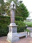 | |||
| Eastfield, Road Bridge Over Former Newtyle Railway | 56°31′30″N 3°04′27″W | Category B | 6492 |  | |||
| Kirkton Of Auchterhouse,Kirkton Farmhouse Including Coach House And Stable And Boundary Walls And Gateposts | 56°31′35″N 3°03′59″W | Category C(S) | 6495 | | |||
| Pitpointie, Pitpointie Farmhouse Including Thatched Game Store, Enclosing Wall And Gatepiers, Walled Garden And Coach House, Gatepiers And Adjoining Walls At S,And Timber Piers At W | 56°31′29″N 3°03′15″W | Category B | 6497 | | |||
| Auchterhouse Old Mansion House Hotel Laundry | 56°31′23″N 3°05′16″W | Category B | 6474 | | |||
| Auchterhouse Bridge Cottage Weir Adjacent To Road Bridge Over Auchterhouse Burn | 56°31′26″N 3°05′17″W | Category B | 5688 | | |||
| Kirkton Of Auchterhouse, Former Manse Including Buildings Identified As Old Manse And Steading And Boundary Walls | 56°31′50″N 3°04′13″W | Category B | 6494 | | |||
| Templeton, Road Bridge Over Dichty Water | 56°30′26″N 3°02′55″W | Category B | 6499 | | |||
| Auchterhouse Old Mansion House Hotel Stable/Coach House/Squash Court | 56°31′23″N 3°05′18″W | Category C(S) | 6476 | | |||
| Balbeuchley, Balbeuchley Steading | 56°31′42″N 3°02′29″W | Category B | 6481 | | |||
| Dronley Road, Bridge Over Dronley Burn | 56°30′30″N 3°04′03″W | Category B | 6485 | 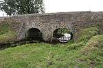 | |||
| Eastfield, Eastfield Steading | 56°31′20″N 3°04′27″W | Category B | 6491 | | |||
| Auchterhouse Old Mansion House Hotel Including Game Store Garden And Enclosing Walls | 56°31′22″N 3°05′20″W | Category A | 5689 |  | |||
| South Fallows, Road Bridge Over Fallows Burn | 56°30′53″N 3°02′01″W | Category C(S) | 6498 | | |||
| Auchterhouse Old Mansion House Hotel Sundial | 56°31′22″N 3°05′21″W | Category B | 6477 | | |||
| Auchterhouse Old Mansion House Hotel, Wallace Tower | 56°31′22″N 3°05′17″W | Category B | 6479 | | |||
| Balbeuchley, Balbeuchley House, Including Walled Garden, Boundary Wall And Gateposts | 56°31′45″N 3°02′37″W | Category B | 6480 | | |||
| Bonnyton,Bonnyton Bridge Road Bridge Over Den Burn | 56°32′17″N 3°05′49″W | Category C(S) | 6482 | | |||
| East Adamston,Farmhouse Including Boundary Wall | 56°30′24″N 3°05′28″W | Category B | 6487 | | |||
| East Adamston, Road Bridge Over Dichty Water | 56°30′16″N 3°04′56″W | Category B | 6489 | 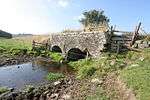 | |||
| Eastfield, Eastfield Farmhouse Including Boundary Walls | 56°31′18″N 3°04′23″W | Category C(S) | 6490 | | |||
| Kirkton Of Auchterhouse, Auchterhouse Parish Church Including Churchyard | 56°31′50″N 3°04′16″W | Category B | 6493 | | |||
| Auchterhouse, Auchterhouse Park, (Formerly Sidlaw Hospital), Including Gatepiers | 56°32′29″N 3°03′47″W | Category B | 5685 | | |||
| Auchterhouse Old Mansion House Hotel Lodge | 56°31′24″N 3°05′17″W | Category B | 6475 | | |||
| Auchterhouse Old Mansion House Hotel Turbine House Including Machinery And Water Supply Pipe From Weir | 56°31′14″N 3°05′19″W | Category B | 6478 | | |||
| Dronley, Dronley Mill | 56°30′36″N 3°04′12″W | Category C(S) | 6484 | | |||
| Auchterhouse Old Mansion House Hotel Dovecot | 56°31′24″N 3°05′14″W | Category A | 5690 | | |||
| Auchterhouse Road Bridge Over Auchterhouse Burn | 56°31′26″N 3°05′17″W | Category B | 5687 | | |||
| Auchterhouse Old Mansion House Hotel Gatepiers And Adjoining Boundary Walls | 56°31′25″N 3°05′18″W | Category B | 5691 | | |||
| Denhead, Former Road Bridge Over Dronley Burn | 56°30′53″N 3°04′50″W | Category B | 6483 | | |||
| Dronley, Dronley House Including Gatepiers And Quadrants | 56°30′58″N 3°04′19″W | Category B | 6486 | | |||
| East Adamston Mill, Road Bridge Over Dichty Water | 56°30′19″N 3°05′13″W | Category C(S) | 6488 | | |||
| Auchterhouse Auchterhouse Park Formerly Sidlaw Hospital South Lodge | 56°32′26″N 3°03′45″W | Category C(S) | 5686 | |
Key
The scheme for classifying buildings in Scotland is:
- Category A: "buildings of national or international importance, either architectural or historic; or fine, little-altered examples of some particular period, style or building type."[1]
- Category B: "buildings of regional or more than local importance; or major examples of some particular period, style or building type, which may have been altered."[1]
- Category C: "buildings of local importance; lesser examples of any period, style, or building type, as originally constructed or moderately altered; and simple traditional buildings which group well with other listed buildings."[1]
In March 2016 there were 47,288 listed buildings in Scotland. Of these, 8% were Category A, and 50% were Category B, with the remaining 42% being Category C.[2]
gollark: People mow lawns when they are too long. Grass grows when sunny. QED.
gollark: That's not spurious, that seems totally related.
gollark: That one is in memeCLOUD™, I think.
gollark: Apparently I never changed my "about me" from "Test test test Test test test Test test test Test test test Test test test Test test test Test test test Test test test Test test test Test test test Test test test Test test test Test test".
gollark: Oh, those, I forgot their contents.
See also
Notes
- Sometimes known as OSGB36, the grid reference (where provided) is based on the British national grid reference system used by the Ordnance Survey.
• "Guide to National Grid". Ordnance Survey. Retrieved 2007-12-12.
• "Get-a-map". Ordnance Survey. Retrieved 2007-12-17. - Historic Environment Scotland assign a unique alphanumeric identifier to each designated site in Scotland, for listed buildings this always begins with "LB", for example "LB12345".
References
- All entries, addresses and coordinates are based on data from Historic Scotland. This data falls under the Open Government Licence
- "What is Listing?". Historic Environment Scotland. Retrieved 29 May 2018.
- Scotland's Historic Environment Audit 2016 (PDF). Historic Environment Scotland and the Built Environment Forum Scotland. pp. 15–16. Retrieved 29 May 2018.
This article is issued from Wikipedia. The text is licensed under Creative Commons - Attribution - Sharealike. Additional terms may apply for the media files.