List of listed buildings in Ardclach, Highland
List
| Name | Location | Date Listed | Grid Ref. [note 1] | Geo-coordinates | Notes | LB Number [note 2] | Image |
|---|---|---|---|---|---|---|---|
| 1-6 (Inclusive) Ferness Village | 57°28′57″N 3°43′54″W | Category B | 5103 |  | |||
| Whitefold, Highland Boath Bridge Over Muckle Burn | 57°28′42″N 3°50′27″W | Category B | 5107 | | |||
| Coulmony House And Walled Garden | 57°30′25″N 3°42′47″W | Category B | 555 | | |||
| Ardclach Old Manse Steading And Garden Wall | 57°29′35″N 3°45′17″W | Category B | 553 | | |||
| Dulsie Bridge (Over River Findhorn) | 57°27′02″N 3°46′53″W | Category A | 557 | 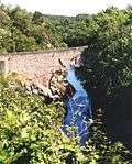 | |||
| Dulsie Farmhouse, Dulsie Bridge | 57°27′06″N 3°46′51″W | Category C(S) | 558 | | |||
| Ardclach Old Parish Church And Burial Ground | 57°29′00″N 3°44′42″W | Category B | 554 | | |||
| Daltullich Bridge Over River Findhorn | 57°31′05″N 3°41′39″W | Category B | 556 | | |||
| Ferness Village, Schoolhouse With School | 57°28′59″N 3°43′53″W | Category C(S) | 559 | | |||
| Glenferness House | 57°27′48″N 3°46′24″W | Category A | 560 | | |||
| Newton Of Belivat | 57°30′21″N 3°44′38″W | Category C(S) | 565 | | |||
| Glenferness House Stables | 57°27′52″N 3°46′28″W | Category B | 561 | | |||
| Ardclach Bell Tower | 57°29′10″N 3°44′48″W | Category A | 551 | 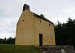 | |||
| Ardclach Parish Church (Church Of Scotland) | 57°29′31″N 3°45′21″W | Category B | 552 | | |||
| Glenferness House Gate Lodge, Gate Piers And Entrance Gates | 57°27′56″N 3°44′58″W | Category B | 563 | | |||
| Glenferness House Walled Garden And Gardener's House | 57°27′54″N 3°46′21″W | Category B | 562 | | |||
| Tomnagee, Farmhouse And Steading | 57°32′03″N 3°44′29″W | Category B | 566 | | |||
| Logie Bridge, Ferness (Over River Findhorn) | 57°29′39″N 3°44′15″W | Category A | 564 | 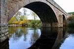 |
Key
The scheme for classifying buildings in Scotland is:
- Category A: "buildings of national or international importance, either architectural or historic; or fine, little-altered examples of some particular period, style or building type."[1]
- Category B: "buildings of regional or more than local importance; or major examples of some particular period, style or building type, which may have been altered."[1]
- Category C: "buildings of local importance; lesser examples of any period, style, or building type, as originally constructed or moderately altered; and simple traditional buildings which group well with other listed buildings."[1]
In March 2016 there were 47,288 listed buildings in Scotland. Of these, 8% were Category A, and 50% were Category B, with the remaining 42% being Category C.[2]
gollark: Fun Things to Do With a CB Prize:- breed with random high-gen messy- breed with own children- randomly dump 2Gs in the AP or offer them on trades for low-value stuff- ND the 2Gs- give the 2Gs only to those who figure out the answer to a riddle
gollark: Well, at least ones on here.
gollark: Yes, there are viewbombers secretly watching our every message.
gollark: I kind of want a CB prize just to irritate people with what I do with its offspring.
gollark: That must be it, then.
See also
Notes
- Sometimes known as OSGB36, the grid reference (where provided) is based on the British national grid reference system used by the Ordnance Survey.
• "Guide to National Grid". Ordnance Survey. Retrieved 2007-12-12.
• "Get-a-map". Ordnance Survey. Retrieved 2007-12-17. - Historic Environment Scotland assign a unique alphanumeric identifier to each designated site in Scotland, for listed buildings this always begins with "LB", for example "LB12345".
References
- All entries, addresses and coordinates are based on data from Historic Scotland. This data falls under the Open Government Licence
- "What is Listing?". Historic Environment Scotland. Retrieved 29 May 2018.
- Scotland's Historic Environment Audit 2016 (PDF). Historic Environment Scotland and the Built Environment Forum Scotland. pp. 15–16. Retrieved 29 May 2018.
This article is issued from Wikipedia. The text is licensed under Creative Commons - Attribution - Sharealike. Additional terms may apply for the media files.