List of listed buildings in Aberdour, Fife
List
| Name | Location | Date Listed | Grid Ref. [note 1] | Geo-coordinates | Notes | LB Number [note 2] | Image |
|---|---|---|---|---|---|---|---|
| Aberdour, 1, 2, 3, 4 Kirk Cottages, High Street | 56°03′10″N 3°18′21″W | Category B | 3590 |  | |||
| The Murrell Including Ancillary Buildings, Garden Terraces, Walled Raised And Water Gardens And Rockery | 56°03′58″N 3°18′23″W | Category A | 3598 | | |||
| Cullaloe Lodge | 56°04′22″N 3°18′34″W | Category B | 3603 | | |||
| Aberdour, Mclauchlan Rise, St Colme House Dovecot | 56°03′07″N 3°18′32″W | Category B | 3607 | | |||
| Aberdour, 8 Livingston Lane | 56°03′13″N 3°18′01″W | Category C(S) | 3612 | | |||
| Cullaloe Temple | 56°04′44″N 3°19′12″W | Category B | 3572 | | |||
| Aberdour, 4 Sands Place, High Street | 56°03′10″N 3°18′21″W | Category C(S) | 49682 | | |||
| Bouprie Banks Farm Steading | 56°03′32″N 3°19′26″W | Category B | 49685 | | |||
| Aberdour, 5 Sands Place, High Street | 56°03′10″N 3°18′21″W | Category C(S) | 3592 | | |||
| Aberdour, 6 Sands Place, High Street,Countess Of Moray | 56°03′09″N 3°18′23″W | Category B | 3593 | | |||
| Balmule Dovecot | 56°04′46″N 3°16′55″W | Category B | 3599 | | |||
| Aberdour, Aberdour Castle West Gateway | 56°03′16″N 3°18′01″W | Category B | 3609 | | |||
| Aberdour, 28 High Street, Church Hall Including Graveyard And Boundary Wall | 56°03′14″N 3°18′08″W | Category B | 3615 | | |||
| Aberdour, 45, 47 Main Street, Wellside | 56°03′25″N 3°17′47″W | Category C(S) | 3635 | | |||
| Aberdour, Aberdour House | 56°03′16″N 3°17′59″W | Category A | 3636 | | |||
| Aberdour, Aberdour Castle Sundial (Formerly At Aberdour House) | 56°03′19″N 3°17′51″W | Category A | 3637 | | |||
| Aberdour, 2 Station Place, Rose Cottage, Including Iron Railings, 4 Station Place, Melville Cottage | 56°03′16″N 3°18′05″W | Category C(S) | 3641 | | |||
| Aberdour, 7, 9, 11 Manse Street | 56°03′05″N 3°18′00″W | Category B | 3562 | | |||
| Inchcolm Abbey, Including Ancillary Buildings | 56°01′48″N 3°18′06″W | Category A | 3573 | 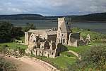 | |||
| Aberdour, Inverkeithing Road, St Columba's Church (Episcopal Church) | 56°03′08″N 3°18′29″W | Category C(S) | 49678 | 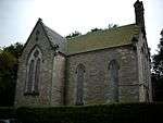 | |||
| Aberdour, 1 Seaside Place, Seaside House Including Iron Railings | 56°03′05″N 3°17′55″W | Category B | 49683 | | |||
| Aberdour, 27, 29, 31, 33 High Street With Boundary Walls, Bee Boles, Well And Trough In Courtyard To Rear | 56°03′13″N 3°18′06″W | Category B | 3587 | | |||
| Aberdour, 18 Manse Street, The Manse | 56°03′10″N 3°18′19″W | Category B | 3591 | | |||
| Cullaloe Tower | 56°05′02″N 3°18′43″W | Category C(S) | 3602 | | |||
| Aberdour, 6, 7 Livingston Lane | 56°03′13″N 3°18′00″W | Category B | 3613 | | |||
| Aberdour, 5 Livingston Lane, Glenelm | 56°03′13″N 3°18′00″W | Category C(S) | 3614 | | |||
| Aberdour, 55 High Street | 56°03′12″N 3°18′08″W | Category C(S) | 3618 | | |||
| Aberdour, Cuttlehill, Aberdour House Obelisk | 56°03′09″N 3°17′56″W | Category B | 3638 | | |||
| Aberdour, Hillside House Walled Garden | 56°03′31″N 3°18′06″W | Category C(S) | 49677 | | |||
| Aberdour, 73 Main Street, Including Boundary Wall | 56°03′28″N 3°17′41″W | Category B | 49679 | | |||
| Aberdour, 22 Shore Road, Whitehall Including Boundary Walls And Gatepiers | 56°03′11″N 3°18′00″W | Category C(S) | 49684 | | |||
| Mill Farm Road, Mill Farmhouse And Steading Including Boundary Walls | 56°03′21″N 3°18′29″W | Category B | 45594 | | |||
| Aberdour, Inverkeithing Road, St Colme House North Entrance Gate Lodge Including Quadrant Walls With Railings, Piers And Gates | 56°03′04″N 3°19′02″W | Category B | 6633 | | |||
| Aberdour, 73, 75 High Street Including Adjoining Arch | 56°03′12″N 3°18′10″W | Category C(S) | 3586 | | |||
| Aberdour, 4 Seaside Place, St Helen's | 56°03′06″N 3°17′56″W | Category C(S) | 3630 | | |||
| Aberdour, Shore Road, Seabank House Including Boundary Walls | 56°03′04″N 3°17′53″W | Category A | 3632 | | |||
| Aberdour, 36 Main Street | 56°03′23″N 3°17′51″W | Category B | 3574 | | |||
| Aberdour, 41 High Street | 56°03′13″N 3°18′08″W | Category B | 232 | | |||
| Aberdour, 36 High Street | 56°03′13″N 3°18′09″W | Category C(S) | 49676 | | |||
| Aberdour, 64, 66 Main Street | 56°03′25″N 3°17′45″W | Category C(S) | 49680 | | |||
| Aberdour, Aberdour Castle Including
Garden Terraces And Boundary Walls |
56°03′19″N 3°17′54″W | Category A | 6421 | | |||
| Aberdour, 68 High Street | 56°03′12″N 3°18′11″W | Category B | 3588 | | |||
| Aberdour, Hillside House Including Pedestrian Gate To South Boundary Wall | 56°03′26″N 3°18′07″W | Category B | 3596 | | |||
| Aberdour, Aberdour Castle Dovecot | 56°03′17″N 3°17′50″W | Category A | 3611 | | |||
| Aberdour, Aberdour House Entrance Gateway Including Connecting Walls With Terminating Obelisks | 56°03′15″N 3°18′02″W | Category B | 3639 | | |||
| Aberdour, Dour Cottage | 56°03′15″N 3°18′02″W | Category C(S) | 3640 | | |||
| Aberdour, 10,12,14,16 Seaside Place, Forth House | 56°03′05″N 3°17′57″W | Category B | 3565 | | |||
| Easterheughs Including Gate Piers And Boundary Wall,Garage, Boiler House (Former Log Store) And Pump House | 56°03′37″N 3°16′11″W | Category A | 49686 | | |||
| Aberdour, Wester Aberdour Dovecot | 56°03′09″N 3°18′22″W | Category B | 3594 | | |||
| Cullaloe Farmhouse Including Outhouse | 56°04′57″N 3°18′16″W | Category B | 3601 | | |||
| Couston Castle Including Walled Garden And Garage | 56°03′05″N 3°20′13″W | Category C(S) | 3606 | | |||
| Aberdour Kirk, St Filan's (Church Of Scotland) Including Graveyard And Boundary Walls | 56°03′19″N 3°17′49″W | Category A | 3608 | 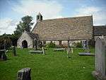 | |||
| Aberdour, 43, 45, 47, 49, 51 High Street Including Rear Outbuildings | 56°03′13″N 3°18′08″W | Category C(S) | 3617 | | |||
| Aberdour Railway Station Including Shelter, Footbridge And Signal Box | 56°03′17″N 3°18′04″W | Category B | 3629 | | |||
| Aberdour, High Street, K6 Telephone Kiosk At Clock Tower | 56°03′15″N 3°18′03″W | Category B | 3550 | | |||
| The Murrel,Kate Randall's Cottage | 56°03′59″N 3°18′09″W | Category B | 3551 | | |||
| Oxcars Lighthouse, Firth Of Forth | 56°01′21″N 3°16′49″W | Category B | 49687 | | |||
| Aberdour, 70 High Street, Anvil House | 56°03′12″N 3°18′12″W | Category C(S) | 3589 | | |||
| Cullaloe Dry Bridge | 56°05′10″N 3°18′08″W | Category C(S) | 3600 | | |||
| Whitehill Dovecot | 56°03′45″N 3°19′13″W | Category B | 3604 | | |||
| Whitehill Policies, Black Lodge Including Boundary Wall | 56°03′26″N 3°19′01″W | Category B | 3605 | | |||
| Aberdour, 57 High Street | 56°03′12″N 3°18′09″W | Category C(S) | 3619 | | |||
| Aberdour, 2 Seaside Place, Clachaig Including Boundary Wall With Post Box | 56°03′06″N 3°17′56″W | Category B | 3631 | | |||
| Aberdour, 13 Manse Street, Woodlee | 56°03′05″N 3°18′01″W | Category B | 3563 | | |||
| Aberdour, 3 Sands Place, High Street, Verona Cottage | 56°03′04″N 3°18′04″W | Category C(S) | 3564 | | |||
| Aberdour, High Street, East Lodge Including Screen Walls, Gates, Gatepiers And Railings | 56°03′10″N 3°18′14″W | Category A | 6632 | | |||
| Aberdour, Harbour Pier Including Workshop/Club House | 56°03′07″N 3°17′40″W | Category B | 3595 | | |||
| Aberdour,Aberdour Castle Walled Garden With Sundial | 56°03′20″N 3°17′49″W | Category A | 3610 | | |||
| Aberdour, 9 Main Street, Templeland | 56°03′23″N 3°17′52″W | Category C(S) | 3633 | | |||
| Aberdour, High Street, The Woodside Hotel | 56°03′11″N 3°18′15″W | Category B | 3560 | | |||
| Aberdour, 2 Sands Place, High Street | 56°03′10″N 3°18′19″W | Category C(S) | 49681 | |
Key
The scheme for classifying buildings in Scotland is:
- Category A: "buildings of national or international importance, either architectural or historic; or fine, little-altered examples of some particular period, style or building type."[1]
- Category B: "buildings of regional or more than local importance; or major examples of some particular period, style or building type, which may have been altered."[1]
- Category C: "buildings of local importance; lesser examples of any period, style, or building type, as originally constructed or moderately altered; and simple traditional buildings which group well with other listed buildings."[1]
In March 2016 there were 47,288 listed buildings in Scotland. Of these, 8% were Category A, and 50% were Category B, with the remaining 42% being Category C.[2]
gollark: So it doesn't actually go forward but a random other one enters?
gollark: Also, yay, I caught an Aeon.
gollark: So when you take an egg the queue goes forward a bit?
gollark: That makes a lot of sense, actually. I thought 5-minute ones added eggs to the front of the queue or something.
gollark: Ah.
See also
Notes
- Sometimes known as OSGB36, the grid reference (where provided) is based on the British national grid reference system used by the Ordnance Survey.
• "Guide to National Grid". Ordnance Survey. Retrieved 2007-12-12.
• "Get-a-map". Ordnance Survey. Retrieved 2007-12-17. - Historic Environment Scotland assign a unique alphanumeric identifier to each designated site in Scotland, for listed buildings this always begins with "LB", for example "LB12345".
References
- All entries, addresses and coordinates are based on data from Historic Scotland. This data falls under the Open Government Licence
- "What is Listing?". Historic Environment Scotland. Retrieved 29 May 2018.
- Scotland's Historic Environment Audit 2016 (PDF). Historic Environment Scotland and the Built Environment Forum Scotland. pp. 15–16. Retrieved 29 May 2018.
This article is issued from Wikipedia. The text is licensed under Creative Commons - Attribution - Sharealike. Additional terms may apply for the media files.