List of listed buildings in Aberdeen/2
List
| Name | Location | Date Listed | Grid Ref. [note 1] | Geo-coordinates | Notes | LB Number [note 2] | Image |
|---|---|---|---|---|---|---|---|
| Morningfield Road And King's Gate, Morningfield Hospital, Including Porter's Lodge, Gatepiers And Boundary Walls | 57°08′48″N 2°08′15″W | Category C(S) | 46160 |  | |||
| 59 Riverside Drive, Deeford, Including Ancillary Structure, Gatepiers And Boundary Walls | 57°07′44″N 2°06′56″W | Category B | 46482 | | |||
| Duthie Park, Temperance Drinking Fountain, Including Urns | 57°07′53″N 2°06′22″W | Category C(S) | 46785 | | |||
| 17-29 (Odd Numbers) Ferryhill Place, Including Gatepiers And Boundary Walls | 57°08′12″N 2°06′11″W | Category B | 46786 | | |||
| 20-30(Even Numbers) Ferryhill Place, Including Gatepiers And Boundary Walls | 57°08′14″N 2°06′12″W | Category B | 46787 | | |||
| 111-119 (Odd Numbers) Great Southern Road And 89 Murray Terrace, Including Boundary Walls | 57°07′57″N 2°06′29″W | Category C(S) | 46791 | | |||
| 182 Market Street | 57°08′33″N 2°05′33″W | Category C(S) | 46792 | | |||
| Railway Viaduct Over River Dee At Ferryhill Junction | 57°07′47″N 2°05′45″W | Category C(S) | 46800 | | |||
| 248 And 250 Rosemount Place, Including Boundary Walls | 57°08′59″N 2°07′16″W | Category C(S) | 46986 | | |||
| 33-39 (Odd Numbers) Belgrave Terrace, Including Boundary Walls | 57°08′51″N 2°07′07″W | Category C(S) | 47455 | | |||
| 12 Carden Place, Including Boundary Walls | 57°08′42″N 2°07′08″W | Category C(S) | 47461 | | |||
| 3 Hamilton Place, Hamilton Lodge, Including Boundary Walls | 57°08′54″N 2°07′22″W | Category C(S) | 47483 | | |||
| 8 And 10 Hamilton Place, Including Boundary Walls | 57°08′55″N 2°07′24″W | Category C(S) | 47486 | | |||
| 60 Hamilton Place, Including Boundary Walls | 57°08′53″N 2°07′34″W | Category C(S) | 47490 | | |||
| Skene Street At Rose Street, Melville Court (Former Melville Church) | 57°08′46″N 2°06′47″W | Category C(S) | 47495 | | |||
| 14 And 16 Westfield Terrace, Including Boundary Walls | 57°08′50″N 2°07′21″W | Category C(S) | 47502 | | |||
| Albyn Place, Albyn Cottage (Originally On Albyn Lane), Including Gatepiers And Boundary Walls, To Rear Of 1 Albyn Place | 57°08′32″N 2°06′48″W | Category C(S) | 47911 | | |||
| 114 Anderson Drive, Ataraxia, Including Gatepiers And Boundary Walls | 57°08′29″N 2°08′33″W | Category C(S) | 47917 | | |||
| 28 Forest Road, Including Gatepiers And Boundary Walls | 57°08′38″N 2°08′06″W | Category B | 47925 | | |||
| 211-229 (Odd Numbers) Great Western Road, Eldon Terrace, Including Boundary Walls | 57°08′12″N 2°07′16″W | Category C(S) | 48514 | | |||
| 403 And 405 Great Western Road At Granville Place, Including Boundary Walls | 57°08′00″N 2°07′51″W | Category C(S) | 48517 | | |||
| 34 Claremont Street, Nazareth House, Including Chapel, Entrance Lodge, Mortuary Chapel, Ancillary Structures, Gates, Gatepiers, Boundary Walls And Railings | 57°08′22″N 2°07′12″W | Category C(S) | 48522 | | |||
| Gerrard Street Baptist Church (Former United Free Church) Including Church Hall And Railings | 57°09′12″N 2°06′08″W | Category B | 49192 | | |||
| Gallowgate, Voluntary Services Aberdeen | 57°09′05″N 2°05′53″W | Category C(S) | 50053 | | |||
| Kaimhill Road, Kaimhill Funeral Home (Formerly Kaimhill Crematorium) Including Memorial Garden, Boundary Walls, Gatepiers And Gates | 57°07′29″N 2°07′53″W | Category B | 50178 | | |||
| 32-52 (Even Nos) Bridge Street And 19-25 (Odd Nos) Crown Terrace | 57°08′40″N 2°06′04″W | Category B | 50622 | | |||
| Footdee, Nos 8, 9, 10, 11, 12, 13, 14 And 15 North Square | 57°08′38″N 2°04′16″W | Category C(S) | 50939 | | |||
| Footdee, No 28 North Square | 57°08′37″N 2°04′21″W | Category C(S) | 50940 | | |||
| 26-38 (Even Nos) Union Street, Esslemont And Macintosh Department Store | 57°08′51″N 2°05′46″W | Category C(S) | 50959 | | |||
| Justice Mill Lane And Holburn Street, Ventilator | 57°08′31″N 2°06′44″W | Category C(S) | 45663 | | |||
| Mid Stocket Road, Oakbank School, Governor's House | 57°08′58″N 2°08′27″W | Category C(S) | 45665 | | |||
| 70 Rubislaw Den North, Selsden, Including Gatepiers And Boundary Walls | 57°08′40″N 2°08′33″W | Category B | 20784 | | |||
| 72 Rubislaw Den North, Including Gatepiers And Boundary Walls | 57°08′40″N 2°08′34″W | Category B | 20785 | | |||
| 5 And 7 Rubislaw Den South At Spademill Road, Including Gatepiers And Boundary Walls | 57°08′33″N 2°08′07″W | Category C(S) | 20789 | | |||
| 22 Rubislaw Den South, Including Gatepiers And Boundary Walls | 57°08′35″N 2°08′15″W | Category C(S) | 20802 | | |||
| 66 Rubislaw Den South, Including Gatepiers And Boundary Walls | 57°08′33″N 2°08′41″W | Category B | 20820 | | |||
| Eday Road Woodend Hospital, Main Building | 57°08′50″N 2°10′18″W | Category B | 20826 | | |||
| Eday Road Woodend Hospital Westholme | 57°08′47″N 2°10′23″W | Category B | 20829 | | |||
| 1-5 (Odd Nos) St Nicholas Street | 57°08′50″N 2°05′53″W | Category C(S) | 20686 | | |||
| 42-44 Union Terrace, 3 Skene Terrace And 26 North Silver Street, Union Hall | 57°08′51″N 2°06′22″W | Category B | 20691 | | |||
| 43 Forest Road At Carlton Place, Including Gatepiers And Boundary Walls | 57°08′41″N 2°08′05″W | Category B | 20699 | | |||
| 14 And 16 Forest Road At Rubislaw Den South, Including Gatepiers And Boundary Walls | 57°08′33″N 2°08′02″W | Category C(S) | 20700 | | |||
| 49 And 51 Queen's Road, Including Gatepiers And Boundary Walls | 57°08′27″N 2°08′07″W | Category C(S) | 20728 | | |||
| 52 And 54 Queen's Road, Including Gatepiers And Boundary Walls | 57°08′30″N 2°08′08″W | Category B | 20741 | | |||
| 66 And 68 Queen's Road, Including Gatepiers And Boundary Walls | 57°08′29″N 2°08′13″W | Category C(S) | 20746 | | |||
| 108 Queen's Road, And Royfold Crescent | 57°08′24″N 2°08′39″W | Category C(S) | 20756 | | |||
| 114 Queen's Road | 57°08′23″N 2°08′42″W | Category B | 20758 | | |||
| 5, 5A And 5B Rubislaw Den North, Including Gatepiers And Boundary Walls | 57°08′40″N 2°08′10″W | Category C(S) | 20761 | | |||
| 2 And 4 Rubislaw Den North At Forest Road, Including Boundary Walls | 57°08′41″N 2°08′08″W | Category C(S) | 20768 | | |||
| 1-4 (Inclusive Numbers), 5, 5A, 6-8 (Inclusive Numbers), 9A, 9B, 10A, 10B, 10C, 11 And 11A Queen's Gardens, Off Queen's Road, Including Gatepiers, Railings And Boundary Walls | 57°08′35″N 2°07′41″W | Category B | 20636 | | |||
| Kepplestone House 179 Queen's Road | 57°08′18″N 2°08′59″W | Category B | 20639 | | |||
| 12 Exchange Street | 57°08′45″N 2°05′51″W | Category C(S) | 20659 | | |||
| 20-24 (Even Nos) Guild Street, St Magnus Court, Including 19-23 (Odd Nos) Stirling Street And 22-28 (Even Nos) Exchange Street And 2 Imperial Place | 57°08′43″N 2°05′49″W | Category C(S) | 20662 | | |||
| 78 And 80 Guild Street, The Station Hotel | 57°08′41″N 2°05′55″W | Category B | 20663 | | |||
| 19 Correction Wynd, Commercial Building At Corner Of St Nicholas Lane | 57°08′49″N 2°05′56″W | Category B | 20681 | | |||
| 3-13 (Inclusive Numbers) South Crown Street, Including Boundary Walls | 57°08′13″N 2°06′02″W | Category C(S) | 20616 | | |||
| Stirling Street, Trinity Street And Carmelite Lane, Carmelite Hotel | 57°08′44″N 2°05′52″W | Category B | 20619 | | |||
| 31 And 37-49 (Odd Numbers) Argyll Place, Including Boundary Walls | 57°09′03″N 2°07′29″W | Category B | 20623 | | |||
| 88 Fountainhall Road At Hamilton Place, Including Gates, Gatepiers And Boundary Walls | 57°08′49″N 2°07′45″W | Category C(S) | 20632 | | |||
| 32 Westburn Road, Asylum Lodge | 57°09′12″N 2°06′52″W | Category C(S) | 20599 | | |||
| Wrights' And Coopers' Place (House 3; Old Number 5) | 57°09′59″N 2°06′06″W | Category B | 20601 | | |||
| Rosemount Viaduct, His Majesty's Theatre | 57°08′53″N 2°06′18″W | Category A | 20605 | 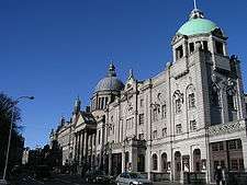 | |||
| 1-7 Abbotsford Place (Inclusive Numbers), Including Boundary Walls | 57°08′17″N 2°06′11″W | Category C(S) | 20608 | | |||
| Union Street, 257,259 | 57°08′40″N 2°06′21″W | Category B | 20537 | | |||
| 82-106 (Even Nos) Union Street | 57°08′49″N 2°05′54″W | Category C(S) | 20554 | | |||
| 158-164 (Even Nos) Union Street | 57°08′44″N 2°06′15″W | Category B | 20563 | | |||
| 6 And 8 Upperkirkgate | 57°08′57″N 2°05′53″W | Category B | 20578 | | |||
| 78-82 (Even Nos) St Clement Street, 25-31 (Odd Nos) York Place And 26-32 (Even Nos) Wellington Street | 57°08′44″N 2°04′48″W | Category B | 20477 | | |||
| St. Machar Drive, 80 Old Aberdeen | 57°10′01″N 2°05′59″W | Category B | 20481 | | |||
| North Silver Street 27, 29 And 33 Skene Terrace | 57°08′50″N 2°06′24″W | Category C(S) | 20490 | | |||
| Spital, 49 | 57°09′31″N 2°06′00″W | Category B | 20509 | | |||
| 118-122 (Even Nos) King Street | 57°09′03″N 2°05′37″W | Category B | 20408 | | |||
| 142 King Street | 57°09′04″N 2°05′36″W | Category C(S) | 20412 | | |||
| 5-9 (Odd Nos) Marischal Street | 57°08′52″N 2°05′35″W | Category B | 20423 | | |||
| 29-33 (Odd Nos) Marischal Street | 57°08′51″N 2°05′34″W | Category B | 20427 | | |||
| 49-53 (Odd Nos) Marischal Street | 57°08′48″N 2°05′31″W | Category C(S) | 20431 | | |||
| 55, 57 Marischal Street | 57°08′48″N 2°05′30″W | Category B | 20432 | | |||
| 28-32 (Even Nos) Marischal Street | 57°08′50″N 2°05′35″W | Category B | 20436 | | |||
| The Colwyn 820 Great Northern Road | 57°10′24″N 2°08′44″W | Category B | 20451 | | |||
| 41 And 42 Regent Quay | 57°08′48″N 2°05′26″W | Category B | 20463 | | |||
| 76, 77 And 78 Regent Quay | 57°08′48″N 2°05′16″W | Category C(S) | 20468 | | |||
| Golden Square, 10, 11, 12 | 57°08′47″N 2°06′19″W | Category B | 20325 | | |||
| 90 And 92 Hamilton Place, Including Gatepiers And Boundary Walls | 57°08′50″N 2°07′44″W | Category A | 20342 |  | |||
| High Street, 25, (West Side) | 57°09′54″N 2°06′08″W | Category B | 20350 | | |||
| High Street, 65, (West Side) And 2 Thom's Place, Old Aberdeen | 57°09′57″N 2°06′08″W | Category B | 20358 | | |||
| High Street, 111, 113 (West Side) Old Aberdeen | 57°10′01″N 2°06′09″W | Category B | 20366 | | |||
| High Street, 70 (East Side) Old Aberdeen | 57°09′57″N 2°06′07″W | Category B | 20370 | | |||
| Old Aberdeen, High Street, Shed Immediately To North Of Number 70 | 57°09′58″N 2°06′07″W | Category C(S) | 20371 | | |||
| High Street, 90 (East Side) Old Aberdeen | 57°10′00″N 2°06′08″W | Category B | 20373 | | |||
| High Street, 96 (East Side) Old Aberdeen | 57°10′00″N 2°06′07″W | Category A | 20374 | .jpg) | |||
| Huntly Street, 23, 25, 27 | 57°08′42″N 2°06′24″W | Category C(S) | 20380 | | |||
| 1-7 (Odd Nos) Justice Street, Including Pend To Chapel Court | 57°08′55″N 2°05′14″W | Category B | 20384 | | |||
| 77-97 (Odd Nos) King Street | 57°09′01″N 2°05′39″W | Category B | 20389 | | |||
| 159-173 (Odd Nos) King Street | 57°09′05″N 2°05′40″W | Category C(S) | 20392 | | |||
| 36-48 (Even Nos) King Street | 57°08′58″N 2°05′36″W | Category B | 20400 | | |||
| Golden Square, 1, 2, 3 | 57°08′44″N 2°06′16″W | Category B | 20322 | | |||
| College Bounds, 10, 12 (East Side) Old Aberdeen | 57°09′43″N 2°06′05″W | Category B | 20224 | | |||
| College Bounds, 14 (East Side) Old Aberdeen | 57°09′43″N 2°06′05″W | Category B | 20225 | | |||
| College Bounds, 18 (East Side) Old Aberdeen | 57°09′44″N 2°06′05″W | Category B | 20226 | | |||
| College Bounds, 42 (East Side) Old Aberdeen | 57°09′46″N 2°06′06″W | Category B | 20233 | | |||
| College Bounds, 44, 46 (East Side) Old Aberdeen | 57°09′47″N 2°06′06″W | Category B | 20234 | | |||
| Crown Street, Former Trinity Uf Church | 57°08′37″N 2°06′10″W | Category C(S) | 20239 | | |||
| Crown Street 111-119 And 9 St. Mary's Place | 57°08′33″N 2°06′05″W | Category B | 20245 | | |||
| 8-10 (Even Nos) Crown Street With 1-3 (Odd Nos) Langstane Place (Including The Star And Garter Ph) | 57°08′41″N 2°06′14″W | Category B | 20247 | | |||
| 77 Dee Street | 57°08′31″N 2°06′09″W | Category C(S) | 20265 | | |||
| 9 And 10 Devanha Terrace, Including Boundary Walls And Railings Enclosing Garden Across Road Opposite Front Elevation | 57°08′14″N 2°06′00″W | Category C(S) | 20269 | | |||
| Don Street, 25 (West Side) Old Aberdeen | 57°10′04″N 2°06′06″W | Category C(S) | 20277 | | |||
| Don Street, 43 (West Side) Old Aberdeen | 57°10′05″N 2°06′03″W | Category B | 20279 | | |||
| Don Street, 18 (East Side) Old Aberdeen | 57°10′03″N 2°06′06″W | Category B | 20287 | | |||
| Don Street, 28 (East Side) Old Aberdeen | 57°10′04″N 2°06′05″W | Category C(S) | 20289 | | |||
| 1 And 2 Carden Terrace, Including Boundary Walls | 57°08′41″N 2°07′04″W | Category C(S) | 20158 | | |||
| 5 And 6 Carden Terrace, Including Boundary Walls | 57°08′40″N 2°07′08″W | Category C(S) | 20161 | | |||
| 19-23 (Inclusive Nos) Castle Street | 57°08′55″N 2°05′33″W | Category B | 20167 | | |||
| 42-44 (Inclusive Nos) Castle Street | 57°08′53″N 2°05′33″W | Category C(S) | 20170 | | |||
| 55, 56 And 57 Castle Street | 57°08′51″N 2°05′38″W | Category B | 20175 | | |||
| Chanonry, 13 Boundary Walls | 57°10′08″N 2°06′09″W | Category B | 20193 | | |||
| College Bounds, 1 (West Side) Old Aberdeen | 57°09′42″N 2°06′05″W | Category B | 20206 | | |||
| College Bounds, 29 (West Side) Old Aberdeen | 57°09′46″N 2°06′07″W | Category B | 20215 | | |||
| College Bounds (West Side) Walls And Gates Powis Lodge | 57°09′50″N 2°06′09″W | Category B | 20219 | | |||
| 34 Albyn Place, Including Gatepiers And Boundary Walls | 57°08′34″N 2°07′24″W | Category B | 20123 | | |||
| Bon Accord Street, 56, 58 | 57°08′31″N 2°06′19″W | Category B | 20147 | | |||
| Bon Accord Street, 64-68 (Even Nos) | 57°08′30″N 2°06′18″W | Category C(S) | 20149 | | |||
| Skene Street And Esslemont Avenue, Aberdeen Grammar School | 57°08′49″N 2°06′53″W | Category B | 20084 | 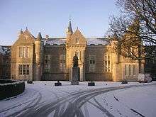 | |||
| Esslemont Avenue At Rosemount Place And Belgrave Terrace, Rosemount Community Education Centre (Formerly Rosemount School), Including Boundary Walls | 57°08′58″N 2°07′02″W | Category B | 20091 | | |||
| Ashgrove House, 49 Beattie Avenue | 57°09′33″N 2°07′25″W | Category B | 20097 | | |||
| 12 And 14 Devanha Gardens, Devanha House, Including Piers And Boundary Walls | 57°08′10″N 2°06′08″W | Category A | 20098 |  | |||
| Old Aberdeen Town House, High Street, Old Aberdeen | 57°10′02″N 2°06′08″W | Category A | 19992 | 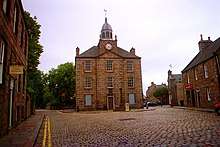 | |||
| Public Library, Rosemount Viaduct | 57°08′53″N 2°06′21″W | Category C(S) | 19993 | 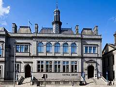 | |||
| Aberdeen Royal Infirmary Woolmanhill | 57°08′57″N 2°06′20″W | Category A | 19995 | .jpg) | |||
| Gordon, Rev. Charles, St. Peter's R.C. School, Nelson Street | 57°09′17″N 2°05′49″W | Category B | 20008 | | |||
| March Stone No. 60 In Froghall Road Outside Granite Works Of Charles Mcdonald Ltd. And Opposite No. 26 | 57°09′26″N 2°06′11″W | Category B | 20040 |  | |||
| March Stone Cr At Rear Of Foot Pavement On South-West Side Of Jack's Brae About 60 Yards South East Of Northfield Place | 57°08′54″N 2°06′42″W | Category B | 20048 | | |||
| St. Peter's Cemetery, Moir Of Scotstoun Mausoleum | 57°09′36″N 2°05′57″W | Category C(S) | 20061 | | |||
| Stonehaven Road And Anderson Drive South, Bridge Of Dee, Over River Dee, Including Sundial | 57°07′22″N 2°07′08″W | Category A | 20068 | 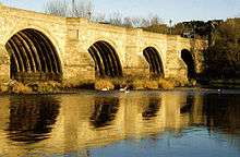 | |||
| Riverside Drive, Ruthrieston Pack Bridge Over Ruthrieston Burn | 57°07′33″N 2°07′05″W | Category B | 20071 | | |||
| Victoria Bridge Over River Dee, At Market Street And Victoria Road | 57°08′24″N 2°05′22″W | Category B | 20072 | | |||
| Craigiebuckler Church (C. Of S.), Springfield Road | 57°08′16″N 2°09′18″W | Category B | 19938 | | |||
| St. Machar's Cathedral, Chanonry | 57°10′12″N 2°06′08″W | Category A | 19957 | 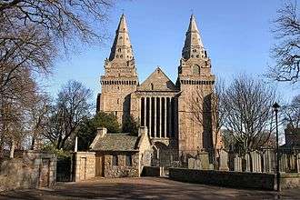 | |||
| St. Mary's (R. C.) Cathedral, Presbytery And Halls, 16-20 Huntly Street | 57°08′43″N 2°06′23″W | Category B | 19962 | | |||
| Belmont Street, Former West St Nicholas Kirk House | 57°08′48″N 2°06′03″W | Category B | 19970 | | |||
| St. Peter's Court 191 Victoria Road, Torry | 57°08′13″N 2°04′57″W | Category B | 19972 | | |||
| Clifton Manor 352 Clifton Road Woodside | 57°10′13″N 2°07′41″W | Category B | 19975 | | |||
| Schoolhill And Blackfriars Street, Art Gallery Including War Memorial And Cowdray Hall, Robert Gordon's College Archway And Former Gray's School Of Art | 57°08′53″N 2°06′10″W | Category A | 19978 | .jpg) | |||
| 25 Fonthill Terrace, The Kessocks, Including Boundary Wall | 57°08′10″N 2°06′35″W | Category B | 46479 | | |||
| Hardgate At Strawberry Bank Gardens, The Hardgate Well | 57°08′33″N 2°06′32″W | Category C(S) | 46520 | | |||
| Duthie Park, Bowling Pavilion | 57°07′51″N 2°06′02″W | Category C(S) | 46778 | | |||
| 62 And 64 Polmuir Road, Including Steps And Boundary Wall | 57°07′59″N 2°06′11″W | Category C(S) | 46799 | | |||
| Rosemount Place And Loanhead Terrace, Rosemount Parish Church Celebration Centre (Church Of Scotland), Including Hall | 57°09′00″N 2°06′58″W | Category C(S) | 46985 | | |||
| 222 And 224 Westburn Road, Including Boundary Walls And Railings | 57°09′10″N 2°07′42″W | Category C(S) | 46991 | | |||
| Mid Stocket Road And Gordondale Road, Mile-End Primary School, Including Servitor's House, Gates, Gatepiers, Boundary Walls And Railings | 57°08′56″N 2°07′54″W | Category C(S) | 46994 | |
Key
The scheme for classifying buildings in Scotland is:
- Category A: "buildings of national or international importance, either architectural or historic; or fine, little-altered examples of some particular period, style or building type."[1]
- Category B: "buildings of regional or more than local importance; or major examples of some particular period, style or building type, which may have been altered."[1]
- Category C: "buildings of local importance; lesser examples of any period, style, or building type, as originally constructed or moderately altered; and simple traditional buildings which group well with other listed buildings."[1]
In March 2016 there were 47,288 listed buildings in Scotland. Of these, 8% were Category A, and 50% were Category B, with the remaining 42% being Category C.[2]
gollark: <:Thonk:445016973798014987> <:Thonk:445016973798014987> <:Thonk:445016973798014987> <:Thonk:445016973798014987> <:Thonk:445016973798014987> <:Thonk:445016973798014987> <:Thonk:445016973798014987> <:Thonk:445016973798014987> <:Thonk:445016973798014987> <:Thonk:445016973798014987> <:Thonk:445016973798014987> <:Thonk:445016973798014987> <:Thonk:445016973798014987> <:Thonk:445016973798014987> <:Thonk:445016973798014987> <:Thonk:445016973798014987> <:Thonk:445016973798014987> <:Thonk:445016973798014987> <:Thonk:445016973798014987> <:Thonk:445016973798014987> <:Thonk:445016973798014987> <:Thonk:445016973798014987> <:Thonk:445016973798014987> <:Thonk:445016973798014987> <:Thonk:445016973798014987> <:Thonk:445016973798014987> <:Thonk:445016973798014987> <:Thonk:445016973798014987>
gollark: <:Thonk:445016973798014987> <:Thonk:445016973798014987> <:Thonk:445016973798014987> <:Thonk:445016973798014987> <:Thonk:445016973798014987>
gollark: ?emojistats
gollark: ?help
gollark: You are clearly a robot.
See also
Notes
- Sometimes known as OSGB36, the grid reference (where provided) is based on the British national grid reference system used by the Ordnance Survey.
• "Guide to National Grid". Ordnance Survey. Retrieved 12 December 2007.
• "Get-a-map". Ordnance Survey. Retrieved 17 December 2007. - Historic Environment Scotland assign a unique alphanumeric identifier to each designated site in Scotland, for listed buildings this always begins with "LB", for example "LB12345".
References
- All entries, addresses and coordinates are based on data from Historic Scotland. This data falls under the Open Government Licence
- "What is Listing?". Historic Environment Scotland. Retrieved 29 May 2018.
- Scotland's Historic Environment Audit 2016 (PDF). Historic Environment Scotland and the Built Environment Forum Scotland. pp. 15–16. Retrieved 29 May 2018.
This article is issued from Wikipedia. The text is licensed under Creative Commons - Attribution - Sharealike. Additional terms may apply for the media files.