List of listed buildings in Aberdeen/1
List
| Name | Location | Date Listed | Grid Ref. [note 1] | Geo-coordinates | Notes | LB Number [note 2] | Image |
|---|---|---|---|---|---|---|---|
| 54-71 (Inclusive Numbers) Springbank Terrace, Including Boundary Walls And Railings | 57°08′25″N 2°06′20″W | Category C(S) | 44958 |  | |||
| 62 And 62A Rubislaw Den North, Including Gatepiers And Boundary Walls | 57°08′40″N 2°08′30″W | Category B | 20781 | | |||
| 64 Rubislaw Den North, Rostrevor, Including Gatepiers And Boundary Walls | 57°08′40″N 2°08′31″W | Category B | 20782 | | |||
| 23 And 25 Rubislaw Den South, Including Boundary Walls | 57°08′33″N 2°08′14″W | Category C(S) | 20790 | | |||
| 29 And 31 Rubislaw Den South, Including Gatepiers And Boundary Walls | 57°08′32″N 2°08′15″W | Category C(S) | 20792 | | |||
| 72 Rubislaw Den South, Duthie Lodge, Including Gatepiers And Boundary Walls | 57°08′32″N 2°08′44″W | Category B | 20823 | | |||
| Broomhill Road, K6 Telephone Kiosk | 57°07′42″N 2°07′42″W | Category B | 20825 | | |||
| Trinity Quay, 1-7 (Inclusive Nos) Trinity Buildings, Formerly Duthie's Warehouse | 57°08′45″N 2°05′43″W | Category B | 20832 | | |||
| Granton Lodge, 8-14 Great Western Place, Granton Lodge, Including Boundary Walls, Gatepiers And Railings | 57°08′24″N 2°07′01″W | Category B | 20836 | | |||
| Powis Terrace, Kittybrewster Auction Mart | 57°09′39″N 2°06′57″W | Category B | 20688 | | |||
| 39-41(Inc Nos) Union Terrace | 57°08′51″N 2°06′21″W | Category B | 20690 | | |||
| 13, 13A, 13B, 15, 17 And 19 Forest Road, Including Gatepiers And Boundary Walls | 57°08′35″N 2°08′00″W | Category B | 20693 | | |||
| 23, 25 And 27 Forest Road At Beaconsfield Place, Langley, Including Gatepiers And Boundary Walls | 57°08′36″N 2°08′01″W | Category B | 20694 | | |||
| 35 And 37 Forest Road, Including Gatepiers And Boundary Walls | 57°08′40″N 2°08′04″W | Category C(S) | 20697 | | |||
| 39 And 41 Forest Road, Including Gatepiers And Boundary Walls | 57°08′41″N 2°08′04″W | Category C(S) | 20698 | | |||
| 24 Forest Road, Including Gatepiers And Boundary Walls | 57°08′37″N 2°08′05″W | Category B | 20702 | | |||
| 26 Forest Road, Including Steps, Gatepiers And Boundary Walls | 57°08′38″N 2°08′05″W | Category B | 20703 | | |||
| 11 Queen's Road, Including Ancillary Structure, Gatepiers And Boundary Walls | 57°08′31″N 2°07′48″W | Category B | 20713 | | |||
| 3 Queen's Gate At Queen's Road And Forest Avenue, Including Gatepiers And Boundary Walls | 57°08′29″N 2°07′59″W | Category B | 20720 | | |||
| 35 Queen's Road, Including Gatepiers And Boundary Walls | 57°08′28″N 2°08′03″W | Category B | 20724 | | |||
| 37 And 39 Queen's Road, Including Gatepiers And Boundary Walls | 57°08′28″N 2°08′04″W | Category C(S) | 20725 | | |||
| 41, 41A, 43 And 43A Queen's Road, Including Gatepiers And Boundary Walls | 57°08′28″N 2°08′05″W | Category C(S) | 20726 | | |||
| 45, 45A, 47 And 47A Queen's Road, Including Gatepiers And Boundary Walls | 57°08′28″N 2°08′06″W | Category C(S) | 20727 | | |||
| 6 Queen's Road, Including Gatepiers And Boundary Walls | 57°08′34″N 2°07′48″W | Category C(S) | 20734 | | |||
| 46 And 48 Queen's Road, Including Gatepiers And Boundary Walls | 57°08′30″N 2°08′06″W | Category B | 20740 | | |||
| 62 Queen's Road, Including Gatepiers And Boundary Walls | 57°08′29″N 2°08′12″W | Category C(S) | 20744 | | |||
| 94 Queen's Road, Including Gatepiers And Boundary Walls | 57°08′26″N 2°08′29″W | Category B | 20753 | | |||
| 116 Queen's Road, Westholme | 57°08′23″N 2°08′43″W | Category B | 20759 | | |||
| 3 And 3A Rubislaw Den North, Gatepiers And Boundary Walls | 57°08′39″N 2°08′08″W | Category C(S) | 20760 | | |||
| 13 Rubislaw Den North, Glenburnie Park, Including Gatepiers And Boundary Walls | 57°08′39″N 2°08′19″W | Category B | 20764 | | |||
| 20 Rubislaw Den North, Including Gatepiers And Boundary Walls | 57°08′42″N 2°08′16″W | Category C(S) | 20773 | | |||
| 1-10 (Inclusive Numbers) Queen's Terrace, At Prince Arthur Street, Including Railings, Lamp Standards, And Balustrading, Gatepiers, Gates And Railings Enclosing Communal Garden To South | 57°08′36″N 2°07′14″W | Category B | 20633 | | |||
| 1-16 (Inclusive Numbers) Albyn Terrace, Including Gatepiers, Boundary Walls And Railings | 57°08′36″N 2°07′26″W | Category B | 20634 | | |||
| 8-26 (Even Nos) Schoolhill | 57°08′53″N 2°06′00″W | Category B | 20645 | | |||
| 46-70 (Even Nos) Schoolhill | 57°08′53″N 2°06′04″W | Category B | 20647 | | |||
| 264 And 266 Holburn Street, Including Boundary Walls | 57°08′14″N 2°06′54″W | Category C(S) | 20651 | | |||
| 39 The Green And 2 And 4 Carmelite Street | 57°08′45″N 2°05′55″W | Category C(S) | 20665 | | |||
| 41 And 43 The Green | 57°08′45″N 2°05′56″W | Category C(S) | 20666 | | |||
| Guild Street Aberdeen Railway Station And Road Overbridge | 57°08′38″N 2°05′54″W | Category A | 20673 | 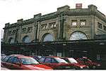 | |||
| Former Station Building At North East Corner Guild Street And College Street | 57°08′39″N 2°06′02″W | Category B | 20674 | | |||
| 12A-15 Correction Wynd | 57°08′49″N 2°05′56″W | Category C(S) | 20680 | | |||
| 2-18 (Even Numbers) Ferryhill Place, Including Gatepiers And Boundary Walls | 57°08′14″N 2°06′10″W | Category B | 20612 | | |||
| 16 Polmuir Road, Rotunda Lodge, Including Boundary Walls | 57°08′08″N 2°06′17″W | Category C(S) | 20614 | | |||
| 55-93 (Odd Numbers) Argyll Place, Including Boundary Walls | 57°09′04″N 2°07′29″W | Category B | 20624 | | |||
| 1-13 (Inclusive Numbers) Argyll Crescent, Including Gates, Gatepiers And Boundary Walls | 57°09′10″N 2°07′33″W | Category B | 20625 | | |||
| 20 And 22 Waverley Place, Prince Regent Hotel, Including Gatepiers And Boundary Walls | 57°08′40″N 2°06′56″W | Category B | 20596 | | |||
| Wrights' And Coopers' Place (Houses 5 And 5A; Old Number 9) | 57°09′59″N 2°06′05″W | Category B | 20603 | | |||
| 1-29 (Odd Numbers) Caledonian Place, Including Boundary Walls | 57°08′20″N 2°06′15″W | Category B | 20606 | | |||
| 2-24 (Even Numbers) Caledonian Place, Including Boundary Walls | 57°08′20″N 2°06′10″W | Category B | 20607 | | |||
| 1 Abbotsford Lane, Woodbine Cottage, Including Boundary Walls | 57°08′15″N 2°06′13″W | Category C(S) | 20609 | | |||
| 1-6 (Inclusive Numbers) Marine Place, Including Gates, Gatepiers, Boundary Walls, Letter Box And Railings | 57°08′13″N 2°06′04″W | Category B | 20610 | | |||
| 3-15 (Odd Numbers) Ferryhill Place, Including Gatepiers And Boundary Walls | 57°08′13″N 2°06′09″W | Category B | 20611 | | |||
| Union Street, 175-197 (Odd Nos) | 57°08′42″N 2°06′12″W | Category B | 20530 | | |||
| Union Street, 221, 223 | 57°08′41″N 2°06′17″W | Category B | 20533 | | |||
| Union Street, 335-369 (Odd Nos) | 57°08′38″N 2°06′25″W | Category C(S) | 20540 | | |||
| Union Street, 381-391 (Odd Nos) | 57°08′37″N 2°06′30″W | Category B | 20542 | | |||
| 78 And 80 Union Street, Royal Bank Of Scotland | 57°08′49″N 2°05′54″W | Category B | 20553 | | |||
| Union Street, 148 | 57°08′44″N 2°06′11″W | Category C(S) | 20558 | | |||
| Union Street, 152 | 57°08′44″N 2°06′13″W | Category B | 20560 | | |||
| 220 Union Street | 57°08′41″N 2°06′23″W | Category C(S) | 20568 | | |||
| 478-484 (Even Numbers) Union Street | 57°08′36″N 2°06′41″W | Category C(S) | 20572 | | |||
| 21-59 (Odd Numbers) Victoria Street, Including 53A Victoria Street And 181 Skene Street, Including Boundary Walls | 57°08′43″N 2°06′53″W | Category B | 20591 | | |||
| 18-28 (Even Numbers) And 18A Victoria Street And 2, 6, 8, 10 And 16 Waverley Place, Including Boundary Walls | 57°08′38″N 2°06′50″W | Category B | 20592 | | |||
| 1-26 (Inclusive Numbers) Rubislaw Terrace, At Rubislaw Place Including Railings, Lamp Standards, Ancillary Structures, And Balustrading, Gatepiers, Gates And Railings Enclosing Communal Garden To South | 57°08′37″N 2°07′00″W | Category B | 20476 | | |||
| St. Mary's Place, 1-6 (Inclusive) | 57°08′34″N 2°06′02″W | Category B | 20482 | | |||
| North Silver Street 17 | 57°08′49″N 2°06′22″W | Category C(S) | 20487 | | |||
| North Silver Street, 14, 16 | 57°08′49″N 2°06′21″W | Category B | 20494 | | |||
| Skene Terrace, 35 | 57°08′50″N 2°06′25″W | Category B | 20501 | | |||
| Skene Terrace, 42 | 57°08′51″N 2°06′27″W | Category B | 20503 | | |||
| 1-15 (Inclusive Nos) Springbank Terrace And 121 Bon Accord Street | 57°08′28″N 2°06′08″W | Category C(S) | 20510 | | |||
| Thom's Place, 8 High Street, Old Aberdeen | 57°09′57″N 2°06′10″W | Category C(S) | 20512 | | |||
| 5-21 (Odd Nos) Union Street And 1 And 2 Castle Street, Union Building | 57°08′51″N 2°05′41″W | Category B | 20514 | | |||
| 23-31 (Odd Nos) Union Street | 57°08′50″N 2°05′43″W | Category C(S) | 20515 | | |||
| 33-37 (Odd Nos) Union Street | 57°08′50″N 2°05′44″W | Category C(S) | 20516 | | |||
| 51 And 53 Union Street | 57°08′49″N 2°05′47″W | Category C(S) | 20518 | | |||
| 3-11 (Inclusive Numbers) Marine Terrace, Including Railings | 57°08′17″N 2°06′06″W | Category B | 20421 | | |||
| 17-21 (Odd Nos) Marischal Street | 57°08′51″N 2°05′34″W | Category B | 20425 | | |||
| 16-20 (Even Nos) Marischal Street | 57°08′51″N 2°05′35″W | Category B | 20434 | | |||
| 34, 34A Marischal Street | 57°08′50″N 2°05′34″W | Category B | 20437 | | |||
| 42, 42A Marischal Street | 57°08′49″N 2°05′33″W | Category B | 20438 | | |||
| 48 Marischal Street | 57°08′48″N 2°05′32″W | Category B | 20441 | | |||
| 2 Queen's Cross And 2 Fountainhall Road, Including Piers And Boundary Walls | 57°08′37″N 2°07′37″W | Category B | 20456 | | |||
| 50, 50A And 50B Queen's Road, Including Ancillary Structures, Gatepiers And Boundary Walls | 57°08′30″N 2°08′07″W | Category A | 20459 | 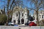 | |||
| Rosemount House, At 28 Rosemount Place | 57°09′04″N 2°06′42″W | Category B | 20470 | | |||
| 1-13 (Inclusive Numbers) Rosemount Square, At Leadside Road, South Mount Street, Richmond Street And Kintore Place | 57°08′58″N 2°06′41″W | Category A | 20471 | 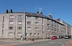 | |||
| 1-27 (Odd Nos) Rosemount Viaduct And 53, 55 Skene Street | 57°08′52″N 2°06′27″W | Category B | 20472 | | |||
| 1-6 (Inclusive Numbers) Rubislaw Place And 21 And 23 Waverley Place, Including Gatepiers And Boundary Walls | 57°08′37″N 2°06′54″W | Category B | 20475 | | |||
| Golden Square, 13, 14, 15 | 57°08′46″N 2°06′21″W | Category B | 20326 | | |||
| Golden Square, 19, 20, 21 | 57°08′44″N 2°06′20″W | Category B | 20329 | | |||
| High Street, 5. (West Side) Old Aberdeen | 57°09′52″N 2°06′08″W | Category B | 20345 | | |||
| High Street 29 (Formerly) Now 1 Douglas Place Old Aberdeen | 57°09′54″N 2°06′08″W | Category B | 20351 | | |||
| Huntly Street, 33-51 (Odd Nos) | 57°08′43″N 2°06′27″W | Category C(S) | 20381 | | |||
| 17, 19, 21 King's Crescent And 1 Jute Street | 57°09′22″N 2°05′59″W | Category B | 20385 | | |||
| 1-5 (Odd Nos) King Street | 57°08′54″N 2°05′37″W | Category B | 20386 | | |||
| Don Street (N.W. Side) 1 Rocky Bank | 57°10′39″N 2°06′01″W | Category B | 20300 | | |||
| Don Street, (N.W. Side) Balgownie Hall Mission (46 Aberdeen Scout Troop) | 57°10′39″N 2°06′00″W | Category B | 20302 | | |||
| The Esplanade, Beach Ballroom | 57°09′19″N 2°04′47″W | Category B | 20314 | .jpg) | |||
| Golden Square, 4, 5, 6 | 57°08′46″N 2°06′16″W | Category B | 20323 | | |||
| Golden Square, 7, 8, 9 | 57°08′46″N 2°06′16″W | Category B | 20324 | | |||
| College Bounds, 48 (East Side) Old Aberdeen | 57°09′47″N 2°06′06″W | Category B | 20235 | | |||
| Crown Street 57-83 (Odd Nos) | 57°08′38″N 2°06′08″W | Category B | 20242 | | |||
| 12-16 (Even Nos) Crown Street | 57°08′41″N 2°06′14″W | Category B | 20248 | | |||
| Crown Street, 82 | 57°08′37″N 2°06′09″W | Category B | 20249 | | |||
| Crown Street 100-122 (Even Nos) And 2, 4 Dee Place | 57°08′33″N 2°06′07″W | Category B | 20251 | | |||
| Crown Terrace, 4-7 (Inclusive) | 57°08′39″N 2°06′06″W | Category C(S) | 20252 | | |||
| Crown Terrace, 13, 14 | 57°08′37″N 2°06′04″W | Category B | 20253 | | |||
| Dee Street, 37, 39 | 57°08′36″N 2°06′12″W | Category C(S) | 20258 | | |||
| 1-8 (Inclusive Numbers) Devanha Terrace, Including Boundary Walls And Railings And Boundary Walls And Railings Enclosing Garden Across Road Opposite Front Elevation | 57°08′14″N 2°06′00″W | Category B | 20268 | | |||
| 31-55 (Odd Numbers) Carden Place And 2 And 4 Prince Arthur Street, Including Boundary Wall And Railings | 57°08′37″N 2°07′24″W | Category B | 20157 | | |||
| 17 Castle Street | 57°08′55″N 2°05′33″W | Category B | 20166 | 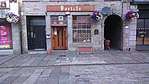 | |||
| Chanonry, 3 (East Side) Old Aberdeen | 57°10′04″N 2°06′08″W | Category B | 20180 | | |||
| Chanonry, 9 (West Side) Mitchell Hospital Old Aberdeen | 57°10′08″N 2°06′13″W | Category A | 20186 | 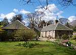 | |||
| Chanonry, 10 (West Side) Old Aberdeen | 57°10′08″N 2°06′19″W | Category B | 20187 | | |||
| Chanonry, 12 (West Side) Tillydrone House, Old Aberdeen | 57°10′11″N 2°06′17″W | Category B | 20190 | | |||
| Chanonry, 12 Boundary Wall, Chanonry And Tillydrone Road | 57°10′11″N 2°06′17″W | Category B | 20191 | | |||
| Chanonry, 16 Boundary Wall | 57°10′10″N 2°06′06″W | Category B | 20198 | | |||
| Cherrybank 1-4 (Inclusive Nos) And 57-63 (Odd Nos) Hardgate | 57°08′30″N 2°06′30″W | Category C(S) | 20203 | | |||
| College Bounds, 5, 5A (West Side) Old Aberdeen | 57°09′43″N 2°06′06″W | Category B | 20208 | | |||
| 2, 2A, 4, 8-16 (Even Numbers) Albyn Place, Including Railings | 57°08′35″N 2°06′51″W | Category B | 20117 | | |||
| 2 Little Belmont Street And 11A Back Wynd | 57°08′50″N 2°06′01″W | Category C(S) | 20125 | | |||
| 19 Belmont Street | 57°08′48″N 2°06′05″W | Category C(S) | 20128 | | |||
| 25 Belmont Street | 57°08′49″N 2°06′06″W | Category B | 20129 | | |||
| Bon Accord Crescent 1-19 (Inclusive) | 57°08′31″N 2°06′24″W | Category B | 20135 | | |||
| Bon Accord Square 1-17 (Odd Nos) And 1-7 (Odd Nos) East Craibstone Street And 1-7 (Odd Nos) West Craibstone Street | 57°08′33″N 2°06′26″W | Category B | 20136 | | |||
| Bon Accord Square, 2-20 (Even Nos) And 35-47 (Odd Nos) Langstane Place, 2, 4, 6, West Craibstone Street Frontage To Square Of Garage At 10 Bon Accord Street And 25 Bon Accord Terrace | 57°08′34″N 2°06′28″W | Category B | 20137 | | |||
| Bon Accord Street, 75-101 (Odd Nos) | 57°08′31″N 2°06′17″W | Category C(S) | 20142 | | |||
| Bon Accord Street 103-119 (Odd Nos) | 57°08′29″N 2°06′15″W | Category C(S) | 20143 | | |||
| Bon Accord Street 38-46 (Even Nos) | 57°08′33″N 2°06′19″W | Category C(S) | 20145 | | |||
| Bon Accord Street, 70-78 (Even Nos) | 57°08′28″N 2°06′16″W | Category C(S) | 20150 | | |||
| Bon Accord Terrace, 32-40 (Even Nos) And 37-45 (Odd Nos) Hardgate | 57°08′32″N 2°06′30″W | Category C(S) | 20153 | | |||
| Bon Accord Terrace, 44, 46 And 49,51 Hardgate | 57°08′31″N 2°06′30″W | Category C(S) | 20154 | | |||
| Albyn Place, Harlaw Academy, Including Gatepiers And Boundary Walls | 57°08′33″N 2°07′01″W | Category B | 20083 | | |||
| Alford Place, The College (Former Christ's College), Including Railings | 57°08′34″N 2°06′45″W | Category B | 20086 | | |||
| 1-23 (Odd Numbers) Albert Street, Including Boundary Walls And Railings | 57°08′40″N 2°06′58″W | Category B | 20113 | | |||
| 2-18 (Even Numbers) Albert Street, Including Boundary Walls And Railings | 57°08′41″N 2°07′01″W | Category B | 20114 | | |||
| 1-34 (Inclusive Numbers) Albert Terrace And 1 Prince Arthur Street, Including Boundary Walls And Railings | 57°08′39″N 2°07′03″W | Category B | 20115 | | |||
| Skene Street And Esslemont Avenue, Aberdeen Grammar School, Lord Byron Statue | 57°08′48″N 2°06′52″W | Category B | 20003 | 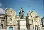 | |||
| March Stone No. 1, In Roadway At S.E. Junction Of Hardgate And Union Glen | 57°08′27″N 2°06′32″W | Category B | 20014 | | |||
| March Stone No. 9, At 126 Craigton Road | 57°07′45″N 2°09′06″W | Category B | 20022 | | |||
| March Stone No. 10, On South Side Of Craigton Road Opposite Slopefield Reservoir | 57°07′35″N 2°09′43″W | Category B | 20023 | | |||
| March Stone No. 50, In Corner Of Don Terrace, At Foot Of Deer Road Above Grandholm Bridge And Near Woodside Railway Station | 57°10′23″N 2°07′41″W | Category B | 20030 | | |||
| March Stone No. 52, In Smithfield Road At The South-East Corner Of Woodside School Boundary Wall | 57°10′12″N 2°07′47″W | Category B | 20032 | | |||
| Crabstone, Hardgate, At Rear Boundary Of 6 West Craibstone Street | 57°08′35″N 2°06′29″W | Category B | 20049 | | |||
| Well Of Spa Spa Street | 57°08′55″N 2°06′23″W | Category B | 20055 | 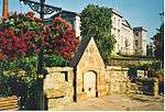 | |||
| Seaton Park, Walled Garden, Don Street | 57°10′28″N 2°05′55″W | Category B | 20062 | | |||
| Schoolhill And Belmont Street, Former Triple Kirks Churches, Including Steeple And Former East Free Church | 57°08′51″N 2°06′09″W | Category A | 19940 | 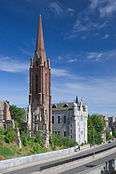 | |||
| Carden Place At Albert Street, Former Melville Carden Place Church, Including Gatepiers, Boundary Walls And Railings | 57°08′44″N 2°07′04″W | Category B | 19944 | | |||
| Sacred Heart, Church Of The (R. C.) And Presbytery House, Grampian And Glenbervie Roads, Torry | 57°08′09″N 2°05′15″W | Category B | 19952 | | |||
| Mid Stocket Road, St Ninian's Church (Church Of Scotland), Including Gates, Gatepiers And Boundary Walls | 57°09′00″N 2°08′06″W | Category B | 19971 | | |||
| St Peter's R.C. Church And Presbytery And 1-5 Chapel Court | 57°08′55″N 2°05′32″W | Category B | 19973 | |
Key
The scheme for classifying buildings in Scotland is:
- Category A: "buildings of national or international importance, either architectural or historic; or fine, little-altered examples of some particular period, style or building type."[1]
- Category B: "buildings of regional or more than local importance; or major examples of some particular period, style or building type, which may have been altered."[1]
- Category C: "buildings of local importance; lesser examples of any period, style, or building type, as originally constructed or moderately altered; and simple traditional buildings which group well with other listed buildings."[1]
In March 2016 there were 47,288 listed buildings in Scotland. Of these, 8% were Category A, and 50% were Category B, with the remaining 42% being Category C.[2]
gollark: There's probably room for some meddling, though.
gollark: Could you not just use it to accelerate a large rock up to, I don't know, 0.99c and then leave it going?
gollark: A large nuclear bomb? The bots will presumably be hardened against anything short of being destroyed directly anyway.
gollark: What could POSSIBLY go wrong?
gollark: 9 persons? How does THAT work?
See also
Notes
- Sometimes known as OSGB36, the grid reference (where provided) is based on the British national grid reference system used by the Ordnance Survey.
• "Guide to National Grid". Ordnance Survey. Retrieved 12 December 2007.
• "Get-a-map". Ordnance Survey. Retrieved 17 December 2007. - Historic Environment Scotland assign a unique alphanumeric identifier to each designated site in Scotland, for listed buildings this always begins with "LB", for example "LB12345".
References
- All entries, addresses and coordinates are based on data from Historic Scotland. This data falls under the Open Government Licence
- "What is Listing?". Historic Environment Scotland. Retrieved 29 May 2018.
- Scotland's Historic Environment Audit 2016 (PDF). Historic Environment Scotland and the Built Environment Forum Scotland. pp. 15–16. Retrieved 29 May 2018.
This article is issued from Wikipedia. The text is licensed under Creative Commons - Attribution - Sharealike. Additional terms may apply for the media files.