List of historic places in Queens County, New Brunswick
This is a list of historic places in Queens County, New Brunswick entered on the Canadian Register of Historic Places, whether they are federal, provincial, or municipal.
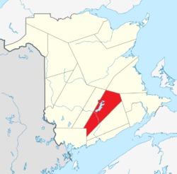
List of historic places
| Name | Address | Coordinates | IDF | IDP | IDM | Image | |
|---|---|---|---|---|---|---|---|
| Barrack Block | Dufferin Drive, Gagetown, NB | 45°50′16″N 66°26′12″W | 15391 |  | |||
| Barrack Block | Dufferin Drive, Gagetown, NB | 45°50′16″N 66°26′13″W | 15364 | | |||
| Drill Hall D15 | CFB Gagetown, Gagetown, NB | 10894 | | ||||
| Drill Hall H12 | St. Jean Avenue, CFB Gagetown, Gagetown, NB | 45°50′42″N 66°27′21″W | 10892 | | |||
| Nehemiah Belyea House | 3259 Lower Cambridge Road, Cambridge-Narrows, NB | 45°45′20″N 66°00′53″W | 15651 | | |||
| Cambridge-Narrows Municipal Building | 6 Municipal Lane, Cambridge-Narrows, NB | 45°49′39″N 65°57′22″W | 15646 | | |||
| Cambridge-Narrows Regional Library | 2216 Lakeview Road, Cambridge-Narrows, NB | 45°49′55″N 65°57′16″W | 15645 | | |||
| Chipman Community Heritage Centre | 238 Main Street, Chipman, NB | 46°10′33″N 65°52′51″W | 12222 | | |||
| Claremont | 104 Tilley Road, Gagetown, NB | 45°47′19″N 66°08′47″W | 15603 | | |||
| Codys Women's Institute Hall | 1 Codys Lane, Johnston, NB | 45°52′29″N 65°49′36″W | 7734 | | |||
| Archdeacon Hiram A. Cody House | 37 Codys Lane, Codys, NB | 45°52′14″N 65°49′48″W | 9991 | | |||
| Cossar Farm Site | 16 Fox Road, Gagetown, NB | 45°44′26″N 66°08′06″W | 15943 | | |||
| Cow Point Site | Scotchtown Road, Scotchtown, NB | 45°52′46″N 66°10′02″W | 13155 | 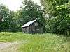 | |||
| Darrah's Insurance Ltd. Building | 267 Main Street, Chipman, NB | 46°10′29″N 65°52′56″W | 12241 | | |||
| Anthony Flower House | Lower Cambridge Road, Cambridge-Narrows, NB | 45°49′41″N 65°57′26″W | 15643 | | |||
| Glenora | 7 Peters Street, Gagetown, NB | 45°47′00″N 66°08′44″W | 15944 | | |||
| Hector House | 20 Front Street, Gagetown, NB | 45°46′48″N 66°08′37″W | 15946 | | |||
| Hendry Farm Lighthouse | Washademoak Lane, Cambridge-Narrows, NB | 45°43′58″N 66°02′54″W | 15497 | | |||
| Jemseg Archaeological Site | Highway 695, Cambridge, NB | 45°49′44″N 66°06′59″W | 7990 | | |||
| Junior Ranks Quarters | Cartier Crescent, Gagetown, NB | 45°50′16″N 66°26′12″W | 15386 | | |||
| Dr. Malcolm MacDonald House | 2224 Lakeview Road, Cambridge-Narrows, NB | 45°49′53″N 65°57′18″W | 15649 | | |||
| Orange Hall Museum | Court House Road, Gagetown, NB | 45°47′09″N 66°08′42″W | 15948 | | |||
| Harry Peters House | 5 Mill Road, Gagetown, NB | 45°46′52″N 66°08′42″W | 15945 | | |||
| James Peters Tombstone | Front Street, Gagetown, NB | 45°47′07″N 66°08′41″W | 15947 | | |||
| Pines Conservation Park | 1307 Bridge Drive, Cambridge-Narrows, NB | 45°49′47″N 65°56′54″W | 15647 | | |||
| Queens County Court House | 16 Court House Road, Gagetown, NB | 45°47′08″N 66°08′53″W | 5978 | 15949 | | ||
| Reid's Mill Smokestack | 32 and 34 Old Mill Road, Gagetown, NB | 45°45′44″N 66°08′25″W | 15952 | | |||
| Charles Robinson House | 2321 Lower Cambridge Road, Cambridge-Narrows, NB | 45°49′23″N 65°57′10″W | 15648 | | |||
| James S. Robinson House | 2349 Lower Cambridge Road, Cambridge-Narrows, NB | 45°49′16″N 65°57′27″W | 15650 | | |||
| St. John's Anglican Church Cemetery | Front Street, Gagetown, NB | 45°47′07″N 66°08′40″W | 15951 | | |||
| Soldiers' Memorial Hall | 81 Tilley Road, Gagetown, NB | 45°47′09″N 66°08′49″W | 15953 | | |||
| Sir Samuel Leonard Tilley House / Tilley House National Historic Site of Canada | 69 Front Street, Gagetown, NB | 45°47′04″N 66°08′41″W | 12662 | 1247 | 15950 | | |
| Wharves of Cambridge-Narrows | Washademoak Lake, western shore, Cambridge-Narrows, NB | 45°47′05″N 65°59′13″W | 15644 | | |||
| Wolastoq National Historic Site of Canada | Entire watershed of Saint John River, central and western New Brunswick, parts of southeastern Quebec, NB | 45°45′37″N 66°08′11″W | 18954 | 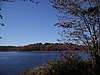 More images |
gollark: Maybe checking which has the most fuel, and running that.
gollark: No idea, but it'd be cool.
gollark: I'm considering somehow coordinating it with the *other* reactor which burns TBU oxide.
gollark: Otherwise it turns off.
gollark: Basically, the top one transmits the powercell's fullness level (obtained via a computercraft thing since comparators appear to not work) and the bottom one receives that, reads the reactor's buffer level (it was meant to be heat but somehow I just get the RF output buffer level), and if the powercell is below full and the buffer empty it turns the reactor on.
See also
| Wikimedia Commons has media related to Cultural heritage monuments in New Brunswick. |
This article is issued from Wikipedia. The text is licensed under Creative Commons - Attribution - Sharealike. Additional terms may apply for the media files.