List of crossings of the Cape Cod Canal
This is a list of crossings of the Cape Cod Canal from its north end in Cape Cod Bay to its southern end in Buzzards Bay. The canal, which was opened in 1914, shortened the route from New York City to Boston by 62 miles.[1]
Center of Canal
Crossings
| Crossing | Carries | Location | Built | Image | Coordinates | References |
|---|---|---|---|---|---|---|
| Sagamore Highway Bridge (former) | United States Route 3 | Sagamore | 1910-1911 | 41°46′30.21″N 70°31′59.52″W | [2] | |
| Sagamore Bridge | U.S. Route 6 | 1933-1935 |  |
41°46′34.14″N 70°32′36.13″W | [2] | |
| Bourne Bridge | Massachusetts Route 28 | Bourne | 1933-1935 |  |
42°50′1.19″N 70°54′24.53″W | [3] |
| Highway bridge (former) | Old Bridge Road | 41.7459°N 70.5962°W | ||||
| Bourne Highway Bridge (former) | Perry Avenue | 1910-1911 |  |
41.7448°N 70.6009°W | [2][3] | |
| Cape Cod Canal Railroad Bridge | Cape Main Line: MassCoastal Railroad | 1933-1935 | 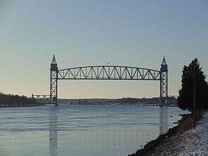 |
41°44′31.16″N 70°36′49.15″W | [4] | |
| Canal Railroad Bridge (former) | Cape Main Line | 1910-1911 | .jpg) |
41°44′41.22″N 70°36′12.30″W | [2] | |
References
- American Geographic Society "The Opening of the Cape Cod Canal" (1914)
- Reid, William (1961). The Building of The Cape Cod Canal: 1627-1914. New York City: George McKibbin And Son Inc. p. 131.
- Turner, Lane; Tute, Lisa (8 August 2012). "Cape Cod Canal and bridges". The Boston Globe. Retrieved 23 June 2013.
- "The Cape Cod Canal's Vertical Lift Railway Bridge" (PDF). United States Army Corps of Engineers. Retrieved 23 June 2013.
See also
- Cape Cod Canal Tunnel
- Third Cape Cod Canal road bridge
This article is issued from Wikipedia. The text is licensed under Creative Commons - Attribution - Sharealike. Additional terms may apply for the media files.