List of New York State Historic Markers in Chenango County, New York
Afton, New York "This is an incomplete list of New York State Historic Markers in Chenango County, New York.[1] Afton, New York
Listings county-wide
| City or Town | Marker name[1] | Image | Date designated | Location | City or Town | Coords | Marker text | |
|---|---|---|---|---|---|---|---|---|
| Afton, Town of, New York | HISTORIC NEW YORK | 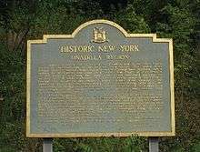 Historic marker of Historic New York, Unadilla Region, Afton, NY. |
Education Department State of New York 1965 Department of Public Works | NYS Route 7 between Bainbridge and Afton, NY at traffic pull off | Afton, Town of, New York | N 42˚14’32.2”
W 75˚29’37.8” |
HISTORIC NEW YORK
UNADILLA REGION Indians living in the valleys of the Unadilla and Susquehanna Rivers played an important role in the region’s early history. | |
| Afton, Town of, New York | MORMON HOUSE | 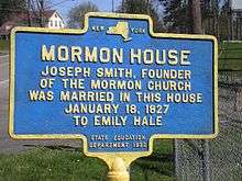 Historic marker of Mormon House, Afton, NY |
State Education Department 1932 | 20 feet east of NYS Route 41 in front of Afton Fair Grounds, Afton, NY | Afton, Town of, New York | N 42˚13'17.9"
W 75˚31'18.3" |
MORMON HOUSE
Joseph Smith, founder of the Mormon Church was married in this house to Emily Hale | |
| Bainbridge, Town of, New York | FIRST TOLL GATE | 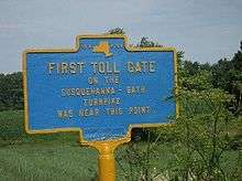 Historic marker of the first toll gate on the Susquehanna-Bath Turnpike was near this point in Bainbridge, NY. |
State Education Department | West Main Street, NYS Route 206. 3 miles northwest of Bainbridge, NY | Bainbridge, Town of, New York | N 42˚18'30.1"
W 75˚31'18.0" |
FIRST TOLL GATE
On the Susquehanna-Bath Turnpike was near this point | |
| Columbus, Town of, New York | ARROW (CARR FARM) | 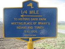 Historic marker of the Carr farm, Brant's Indians and Tories meeting place, 1770-1778 in Columbus, NY. |
Erected 2002 | NYS Route 8 about six miles north of New Berlin, NY. In the town of Columbus, NY | Columbus, Town of, New York | N 42˚39'43.0”
W 75˚19'55.8” |
1/4 MILE
To Historic Carr Farm Meeting Place Of Brant's Indians And Tories 1770–1778 | |
| Lincklaen, Town Of, New York | JOHN B. FINCH | 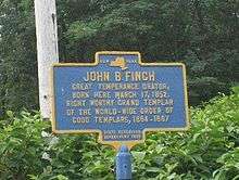 Historic marker of John B. Finch, Lincklaen, NY, Right Worthy Grand Templar of the World Wide Order of Good Templars. |
State Education Department 1938 | Chenango Co. Route 12.1½ miles north of Lincklaen, NY | Lincklaen, Town Of, New York | N 42˚41'44.7"
W 75˚52'24.1” |
JOHN B. FINCH
Great Temperance Orator, Born Here March 17, 1852 Right Worthy Grand Templar Of The World-wide Order Of Good Templars, 1884-1887 | |
| McDonough, Town Of, New York | DEACON TOWNE | 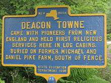 Historic marker of Deacon Towne, he held the first religious services in McDonough, NY. Buried on former Michael and Daniel Pike Farm. |
State Education Department 1938 | NYS Route 220 at village of McDonough, NY, north on Pike Road then right on Beckwith Road | McDonough, Town Of, New York | N 42˚31'16.7”
W 75˚44'44.6” |
DEACON TOWNE
Came With Pioneers From New England And Held First Religious Services Here In Log Cabins Buried On Former Michael And Daniel Pike Farm, South Of Fence. | |
| Columbus, Town of, New York | UNADILLA RIVER | 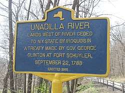 Historic marker of the Unadilla River, lands to the west ceded to New York State by the Iroquois via treaty of September 22, 1788. |
Erected 2002 | NYS Route 8, north of New Berlin, NY in the town of Columbus, NY on east side of road in row of trees overlooking the river | Columbus, Town of, New York | N 42˚39’43.0” W 75˚19’55.8” | UNADILLA RIVER
Lands west of river ceded to NY State by Iroquois in a Treaty made by Gov.George Clinton at Fort Schuyler, September 22, 1778 | |
| Greene, Town Of, New York | CHENANGO CANAL #16 | 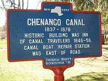 Historic marker of Chenango Canal #16 Historic building was inn of canal travelers 1846-56. Canal boat repair station was east of road. |
Chenango Co. Bicentennial ‘82 | NYS Route 12 at Brisben, NY | Greene, Town Of, New York | N 42°21’54.7”
W 75°40’50.9” |
CHENANGO CANAL 1837-1878
Historic building was inn of canal travelers 1846-56. Canal boat repair station was east of road. | |
| Greene, Town Of, New York | CHENANGO CANAL #17 | 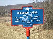 Historic marker of Chenango Canal tow path and bed. |
Chenango Co. Bicentennial ‘82 | NYS Route 12, 2.1 miles south of Oxford, NY | Greene, Town Of, New York | N 42˚21’08.7”
W 75˚43’30.2” |
CHENANGO CANAL 1837-1878
The canal bed and towpath curve around to make level route on the valley floor. | |
| Greene, Town Of, New York | CHENANGO CANAL #19 | 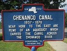 Historic marker, Chenango Canal #19. Ruins of Aqueduct over the Chenango River, Greene, NY |
Chenango Co. Bicentennial ‘82 | NYS Route 12, just south of Greene, NY | Greene, Town Of, New York | N 42˚19’24.6”
W 75˚46’34.5” |
CHENANGO CANAL 1837-1878
Near here to the east are ruins of an aqueduct which carried the canal across the Chenango River | |
| Greene, Town Of, New York | CHENANGO CANAL #20 | 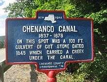 Historic maker, Chenango Canal # 20. 1845 culvert, Greene, NY. |
Chenango Co. Bicentennial ‘82 | NYS Rt. 12, south of the Village of Greene, NY | Greene, Town Of, New York | N 42˚18’31.1
W 75˚46’42.7” |
CHENANGO CANAL 1837-1878
On this spot was a 100 ft. culvert of cut stone dated 1845 which carried a creek under the canal. | |
| North Norwich, Town of, New York | CHENANGO CANAL #5 | 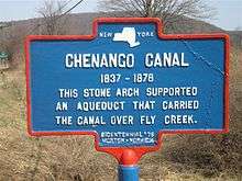 Historic marker of Chenango Canal #5: Aqueduct at North Norwich, NY |
Chenango Co. Bicentennial ‘82 | NYS Route. 12, just south of the village of North Norwich, NY | North Norwich, Town of, New York | N 42°36’35.0”
W 75°31’39.3” |
CHENANGO CANAL 1837-1878
This stone arch supported an aqueduct that carried the canal over Fly Creek. | |
| North Norwich, Town of, New York | CHENANGO CANAL #6 | 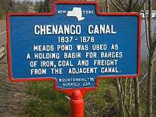 Historic marker of Chenango Canal #6: Meads Pond holding basin at North Norwich, NY |
Chenango Co. Bicentennial ‘82 | NYS Route 12, south of the village of North Norwich, NY at Meads Pond | North Norwich, Town of, New York | N 42°34'18.9"
W 75°31'41.4" |
CHENANGO CANAL 1837-1878
Meads Pond was used as a holding basin for barges of iron, coal and freight from the adjacent canal. | |
| North Norwich, Town of, New York | CHENANGO CANAL #7 | 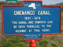 Historic marker of Chenango Canal #7: canal and towpath at North Norwich, NY |
Chenango Co. Bicentennial ‘82 | NYS Route 12 south of the village of North Norwich, NY by the Warren Eaton Airport runway | North Norwich, Town of, New York | N 42°33'58.4"
W 75°31'45.9" |
CHENANGO CANAL 1837-1878
The canal and towpath can be seen parallel to the highway at this point. | |
| Norwich, City of, New York | CHENANGO CANAL #10 | Chenango Co. Bicentennial ‘82 | On NYS Route 12, South Broad Street, Norwich, NY | Norwich, City of, New York | N 42°31’1.7”
W 75°31’22.6” |
CHENANGO CANAL 1837-1878
Just west a large wooden aqueduct spanned the creek.$2,500,000 canal linked area to Utica, Binghamton. | ||
| Norwich, City of, New York | CHENANGO CANAL #11 | Chenango Co. Bicentennial ‘82 | NYS Route 12 | Norwich, Town of, New York | CHENANGO CANAL 1837-1878
Here canal is visible south of old Lock House where packets stopped for passengers. | |||
| Norwich, City of, New York | CHENANGO CANAL #12 | Chenango Co. Bicentennial ‘82 | NYS Route 12 | Norwich, Town of, New York | CHENANGO CANAL 1837-1878
East of road are remains of a lock and feeder pond where canal passed through productive farm country. | |||
| Norwich, City of, New York | CHENANGO CANAL #9 | 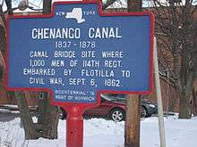 Historic marker of Chenango Canal #9. Bridge, site of where 1,000 men of the 114th NY Regt. left for the Civil War by flotilla, Sept 6, 1862, Norwich, NY. |
Chenango Co. Bicentennial ‘82 | NYS Route 12 | Norwich, City of, New York | N 42°31'42.4
W 75°31'25.4" |
CHENANGO CANAL 1837-1878
Canal bridge site where 1000 men of 114th Regt. embarked by flotilla to Civil War, | |
| Oxford, Town of, New York | CHENANGO CANAL #15 | 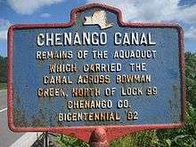 Historic marker of Chenango Canal #15, Bowman Creek, north of Lock 99, Oxford, NY. |
Chenango Co. Bicentennial ‘82 | NYS Route 12 | Oxford, Town of, New York | N 42°24’13.6”
W 75°38’07.9” |
CHENANGO CANAL 1837-1878
Remains of the Aqueduct which carried the Canal across Bowman Creek, north of Lock 99 | |
| Oxford, Town of, New York | CHENANGO CANAL #13 | 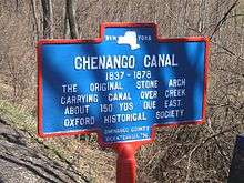 Historic marker of Chenango Canal #13: original stone arch carrying canal over creek at Oxford, NY |
Chenango Co. Bicentennial ‘82 | NYS Route 12 | Oxford, Town of, New York | N 42°22’38.0”
W 75°39’15.7” |
CHENANGO CANAL 1837-1878
Original stone arch carrying canal over creek about 150 yds. due east. | |
| Oxford, Town of, New York | CHENANGO CANAL #14 | 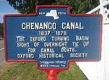 Historic marker of the Chenango Canal #14, turning basin, Oxford, NY. |
Chenango Co. Bicentennial ‘82 | NYS Route.12 | Oxford, Town of, New York | N 42°26’38.0”
W 75°35’45.8” |
CHENANGO CANAL 1837-1878
1837-1878 The Oxford turning basin site of overnight tie up for canal boats. | |
| Oxford, Town of, New York | CHENANGO CANAL #15 | 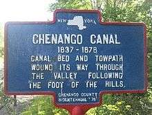 Historic marker Chenango Canal #15 2 canal bed and towpath, Oxford, NY |
Chenango Co. Bicentennial ‘82 | NYS Route 12, Oxford, NY, to Chenango County Rd 3 | Oxford, Town of, New York | N 42°25’26.9”
W 75°38’00.2” |
CHENANGO CANAL 1837-1878
Canal bed and towpath wound its way through the valley following the foot of the hills. | |
| Sherburne, Town of, New York | CHENANGO CANAL #2 | 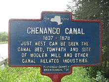 Historic marker of the Chenango Canal #2, Sherburne, NY |
Chenango Co. Bicentennial ‘82 | NYS Route 12, north of Sherburne, NY | Sherburne, Town of, New York | N 42°41’52.5”
W 75°30’49.1” |
CHENANGO CANAL 1837-1878
Just west can be seen the canal bed, towpath and site of woolen mill and other canal related industries | |
| Sherburne, Town of, New York | CHENANGO CANAL #3 | 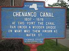 Historic marker of Chenango Canal # 3, canal under wooden bridge, Water Street, Sherburne, NY. |
Chenango Co. Bicentennial ‘82 | NYS Route 80, West State Street, Sherburne, NY | Sherburne, Town of, New York | N 42°40’41.9”
W 75°30’00.4” |
CHENANGO CANAL 1837-1878
At this point the canal ran under a wooden bridge on what was then known as Water St. | |
| Sherburne, Town of, New York | CHENANGO CANAL #4 | 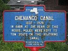 Historic marker of Chenango Canal #4, barn for mules, Sherburne, NY. |
Chenango Co. Bicentennial ‘82 | NYS Route 12, South Main Street, Sherburne, NY | Sherburne, Town of, New York | N 42°40’30.2”
W 75°29’51.5” |
CHENANGO CANAL 1837-1878
In barn at the rear of this house, mules were kept to tow boats on the adjoining canal. | |
| Greene, Town of, New York | FIRST CHURCH IN VILLAGE OF GREENE | 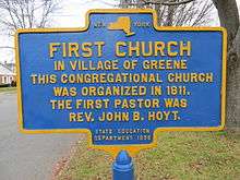 Historic marker of the Congregational Church of Greene, NY. |
Chenango County Bicentennial '76 | North Chenango Street, Greene, NY, in front of First Congregational Church | Greene, Town of, New York | N 42˚19’55.0”
W 75˚46’04.1” |
FIRST CHURCH IN VILLAGE OF GREENE
This Congregational Church was organized in 1811. The first pastor was Rev. John B. Hoyt. | |
| Greene, Town of, New York | FIRST BAPTIST CHURCH | 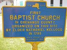 Historic marker of first Baptist Church in Greene, NY |
State Education Department 1936 | South Chenango Street, Greene, NY | Greene, Town of, New York | N 42˚19’39.3”
W 75˚46’18.8” |
FIRST BAPTIST CHURCH
In Chenango County organized on this site by Elder Nathaniel Kellogg in 1795 | |
| Greene, Town of, New York | FIRST BRIDGE | 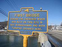 Historic marker of the first bridge over the Chenango River built 1807in Greene, NY. The Susquehanna and Bath Turnpike crossed here. |
State Education Department 1936 | Washington Street, Greene, NY, east side of the Chenango River | Greene, Town of, New York | N 42˚19’41.1”
W 75˚46’03.6” |
FIRST BRIDGE
Across the Chenango river was built on this site in 1807. Susquehanna and Bath Turnpike crossed here | |
| Greene, Town of, New York | FIRST REFRIGERATOR PLANT | 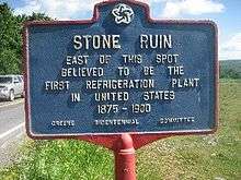 Historic marker of first Refrigeration Plant in the United States, 1875-1900, Greene, NY |
Greene Bicentennial Committee | North Genegantslet Road, north of intersection of Clark Road, Greene, NY | Greene, Town of, New York | N 42˚21’18.9”
W 75˚48’37.0” |
FIRST REFRIGERATOR PLANT
East of this spot believed to be the First Refrigeration Plant in United States 1875-1900 | |
| Greene, Town of, New York | GO-WON-GO MOHAWK | 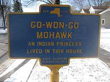 Historic marker of Go-Won-Go Mohawk, home. Indian Princess from Greene, NY |
State Education Department 1936 | South Chenango and Page Street, Greene, NY | Greene, Town of, New York | N 42˚19’45.0”
W 75˚46’12.0” |
GO-WON-GO MOHAWK
An Indian princess lived in this house. | |
| Greene, Town of, New York | EARLY SETTLERS | 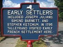 Historic maker of the early settlers of Greene, NY. |
North Chenango Street by Birdsall Brook, Greene, NY | Greene, Town of, New York | N 42˚19’59.5”
W 75˚46’00.6” |
EARLY SETTLERS
Included Joseph Juliand, Simon Barnett, and Stephen Ketchum. In 1795 Talleyrand visited early French settlement here. | ||
| Greene, Town of, New York | GREENE | 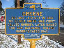 Historic marker of the village of Greene, NY. Laid out in 1806 by Elisha Smith. First called Hornby, renamed for General Nathaniel Greene. |
State Education Department 1936 | Park at Cutler Road, North Washington Street, and North Chenango Street, Greene, NY | Greene, Town of, New York | N 42˚20’12.3”
W 75˚45’57.1” |
GREENE
Village laid out in 1806 by Elisha Smith. Was first called Hornby, later named for Gen. Nathaniel Greene. Incorporated 1842. | |
| Greene, Town of, New York | FIRST HOTEL | 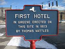 Historic marker of the first hotel in Greene, NY built 1803 by Thomas Wattles. |
South Chenango Street at intersection of Genesee Street, Greene, NY | Greene, Town of, New York | N 42˚19’45.1”
W 75˚46’12.4” |
FIRST HOTEL
In Greene Erected On This Site In 1803 By Thomas Wattles | ||
| Greene, Town of, New York | STEPHEN KETCHUM | 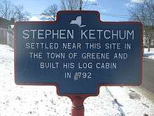 Historic marker of Stephen Ketchum's log cabin, built, 1792 in Greene, NY. |
Corner of South Chenango Street, Greene, NY | Greene, Town of, New York | N 42˚19’45.0”
W 75˚46’12.0” |
STEPHEN KETCHUM
Settled near this site in the Town of and built his log cabin in 1792 | ||
| Greene, Town of, New York | WILCOX HOMESTEAD | 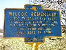 Historic marker of Wilcox Homestead, Greene, NY |
State Education Department 1938 | NYS Route 12 north of Greene, NY, between Elmer Smith Road and Chenango County. Route 3A | Greene, Town of, New York | N 42°20’59.2”
W 75°44’06.7” |
WILCOX HOMESTEAD
First tavern in the Town of erected on this site by Conrad Sharp, 1794. First Town Meeting Held Here in 1798 | |
| Guilford, Town of, New York | FIRST DOCTOR | 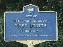 Historic marker of Dr. John Clark the first doctor in Guilford, NY. |
Guilford Bicentennial Historical Committee 1995 | Main Street, Guilford, NY | Guilford, Town of, New York | N 42°24’17.6”
W 75°29’25.3” |
FIRST DOCTOR
Site of First Office and Residence Dr. John Clark | |
| Guilford, Town of, New York | FIRST LOG CABIN | 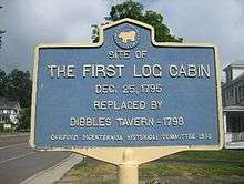 Historic marker of the first log cabin, Guilford, NY. |
Guilford Bicentennial Historical Committee 1995 | Main Street, Guilford, NY | Guilford, Town of, New York | N 42°24’22.9”
W 75°29’32.0” |
FIRST LOG CABIN
Site of The First Log Cabin Dec. 25, 1795 Replaced by Dibbles Tavern - 1798 | |
| McDonough, Town of, New York | EARLY INDUSTRY | 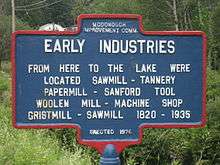 Historic marker of early industry of 1820-1935 in McDonough, NY |
Erected 1976 | NYS Route 220 by Creek Road, Pharsalia, NY | McDonough, Town of, New York | N 42°29’52.7”
W 75°45’26.5” |
EARLY INDUSTRY
From here to the lake were located Sawmill – Tannery - Papermill – Sanford Tool Woolen Mill – Machine Shop - Grist Mill - Sawmill 1820-1935 | |
| McDonough, Town of, New York | KELLY GRANGE | McDonough, Town of, New York | N 42˚29’34.3”
W 75˚44’33.3” |
KELLY GRANGE | ||||
| McDonough, Town of, New York | MCDONOUGH | 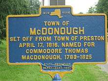 Historic marker of the Town of McDonough, NY. |
McDonough, Town of, New York | N 42°29’55.2”
W 75°46’03.6” |
TOWN OF MCDONOUGH
Set off from Town of Preston April 17, 1816. Named for Commodore Thomas MacDonough, 1783-1825 | |||
| New Berlin, Town of, New York | JOHN P. USHER | 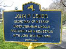 Historic marker of John P. Usher, New Berlin, NY. Secretary of the Interior under President Lincoln. |
Erected 2002 | NYS Route 8 north of Village of New Berlin, NY, north end of park | New Berlin, Town of, New York | N 42°7’38.6”
W 75°19’56.1” |
JOHN P. USHER
Secretary of Interior under Abraham Lincoln Practiced law in New Berlin with John Hyde 1837-1839 | |
| New Berlin, Town of, New York | HISTORIC LAW OFFICE | 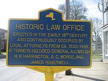 Historic marker of Law Office, 1830-1995, New Berlin, NY |
NYS Route 8, center of Village of New Berlin, NY | New Berlin, Town of, New York | N 42°7’24.7”
W 75°19’56.2” |
HISTORIC LAW OFFICE
Erected in the early 19th century and continuously occupied by local attorneys from CA. 1830-1995. Attorneys included: General A.C. Welch H.H. Harrington, A.C. Morse, and James Honeywell | ||
| New Berlin, Town of, New York | NEW BERLIN | 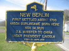 Historic marker of Anson Burlingame, New Berlin, NY |
State Ed. Dept. 1935 | NYS Route 8 south of Village of New Berlin, NY | New Berlin, Town of, New York | N 42°37’05.3”
W 75°19’58.7” |
NEW BERLIN
First settled about 1790 Anson Burlingame born here U.S. Minister to under President Lincoln | |
| New Berlin, Town of, New York | NYO&W Depot | 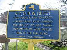 Historic marker of N.Y. O & W Depot, New Berlin, NY. |
Unadilla Valley Railway Soc. | Genesee Street (east) and Railroad Street, New Berlin, NY | New Berlin, Town of, New York | N 42°37’28.9”
W 75°19’43.3” |
N.Y.O.&.W. Depot
1869 Board & Batten Depot- Largest Built by N.Y. Oswego Midland and R.R. its size shows how important New Berlin was to the railroad. | |
| New Berlin, Town of, New York | SITE OF DANIEL SCRIBNER'S HOME | 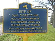 Historic marker of Daniel Scribner's home, built 1790, first in township, New Berlin, NY. |
Scribner's Cemetery Association-Town of New Berlin 2002 | NYS Route 8, 2 mile south of Village of New Berlin, NY | New Berlin, Town of, New York | N 42°35’29.5”
W 75°20’12.7” |
SITE OF DANIEL SCRIBNER'S HOME
Built 1790, First house in 16th Township. Large log building used as trading post and for town meetings | |
| New Berlin, Town of, New York | ST ANDREWS CHURCH AND CEMETERY | 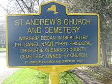 Historic marker of St. Andrews Church and cemetery, New Berlin, NY. |
St. Andrews Church and Cemetery 2002 | NYS Route 8 in Village of New Berlin, NY, south of St. Andrews Church | New Berlin, Town of, New York | N42°37’18.0”
W 75°19’55.5” |
ST ANDREWS CHURCH AND CEMETERY
Worship began in 1808 led by Fr. Daniel Nash. First Episcopal Church in Chenango. Cemetery owned by church. | |
| North Norwich, Town of, New York | OBADIAH GERMAN | 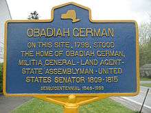 Historic marker of 1798 North Norwich home of Obadiah German, first US Senator Chenango County, NY. |
Sesquicentennial 1849-1999 | Chenango County Road 23 & 23A in front of Town Hall, former schoolhouse in village of North Norwich, NY | North Norwich, Town of, New York | N 42°37'5.3"
W 75°31'38.5" |
OBADIAH GERMAN
On this site, 1798, stood the home of Obadiah German; Militia General - Land Agent - State Assemblyman - United States Senator 1809-1815 | |
| Norwich, Town of, New York | AVERY POWER | 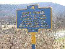 Historic marker of Avery Power, Norwich, NY |
State Education Department 1936 | NYS Route 12, 1 mile south of City of Norwich, NY | Norwich, Town of, New York | N 42°30'37.2"
W 75°31'21.1" |
AVERY POWER
First settler in Norwich 1788, owned adjoining river flat. Lucy Power, first white native (born) of Chenango valley. | |
| Norwich, Town of, New York | CANASAWACTA CREEK | 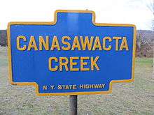 Historic marker of Canasawacta Creek, Norwich, NY |
N.Y. State Highway | NYS Route 12, between the Canasawacta Creek and the entrance to Mt. Hope Cemetery, south of the City of Norwich, NY | Norwich, Town of, New York | N 42 31’09.4”
W 75 31’22.4” |
CANASAWACTA CREEK | |
| Norwich, City of, New York | 1789 | 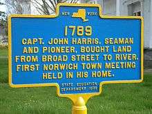 Historic marker of Captain John Harris, Norwich, NY |
State Education Department 1936 | NYS Route 12, north of NYS Route 23 intersection in Norwich, NY | Norwich, City of, New York | N 42°32’17.3”
W 75°31’27.4” |
1789
Capt. John Harris, seaman and pioneer, bought land from Broad Street to river. First town meeting held in his home. | |
| Norwich, City of, New York | FIRST LOG CABIN | 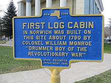 Historic marker of log cabin built by Colonel William Monroe. |
State Education Department 1936 | NYS Route 12, City of Norwich, NY, West Park in front of Chenango County Courthouse | Norwich, City of, New York | N 42 31’54.2” W 75 31’28.7” | FIRST LOG CABIN
In Norwich was built on this site about 1790 by Colonel William Monroe “Drummer Boy of the Revolutionary War.” | |
| Norwich, City of, New York | O&W RAILROAD YARDS | 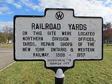 Historic marker of the O & W Railroad yards of Norwich, NY |
Midland Drive, in front of Norwich High School, City of Norwich, NY | Norwich, City of, New York | N 42°31’40.1”
W 75°30’52.5” |
RAILROAD YARDS
On This Site Were Located Northeren Division Offices, Yards, Repair Shops, of the New York, Ontario & Western Railway 1868-1957 | ||
| Norwich, Town of, New York | RUTH BENEDICT | 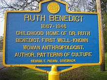 Historic marker of the childhood home of Dr. Ruth Benedict. A well known anthropologist and author of Patterns of Culture. |
NYS Route 12 south of the City of Norwich, NY and Unisom/GE Plant. Red house with white trim | Norwich, Town of, New York | N 42°29’36.5”
W 75°31’56.5” |
RUTH BENEDICT
1887-1948 Childhood Home of Dr. Ruth Benedict. First Well – Known Woman Anthropologist. Author, Patterns of Culture | ||
| Norwich, Town of, New York | THE CASTLE | 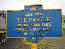 Historic marker of "The Castle" of Norwich, NY |
State Education Department 1936 | East River Road, south of Polkville, NY, 1/2 mile on west side of road | Norwich, Town of, New York | N 42°30’41.8”
W 75°30’32.1” |
¼ Mile West “THE CASTLE”
Oneida Indian Fort Councils held here up to 1790 | |
| Norwich, Town of, New York | WARNING CURVE | 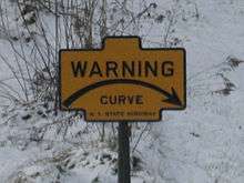 Historic marker of the Warning curve, Norwich, NY. |
New York State Highway | NYS Route 12 south of the City of Norwich, NY, past the cemetery | Norwich, Town of, New York | N 42°30’30.0”
W 75°31’21.2” |
WARNING CURVE | |
| Norwich, Town of, New York | WHITE STORE CHURCH | 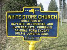 Historic marker of the White Store Church, Norwich, NY |
State Education Department 1935 | NYS Route 8 at White Store Cemetery, Norwich, NY | Norwich, Town of, New York | N 42°29'1.6"
W 75°24'18.4" |
WHITE STORE CHURCH
Built 1820 by Baptists, Methodists, and Universalists. Church in original form except pulpit lowered in 1863. | |
| Norwich, Town of, New York | WILLIAM MONOROE DRUMMER BOY | 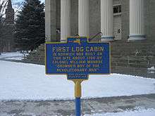 Historic marker of site of first log cabin built in Norwich, NY by Colonel William Monroe. |
NYS Route 12, center of the City of Norwich, NY, on West Side Park by the Chenango County Court House | Norwich, City of, New York | N 42°31’54.2”
W 75°31’28.7” |
FIRST LOG CABIN
Revolutionary Drummer Boy’s House – William Monroe | ||
| Norwich, Town of, New York | FLY MEADOW CREEK | 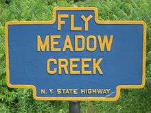 Historic marker of Fly Meadow Creek, Oxford, NY |
NY State Highway | NYS Route 12, at bridge, south of the City of Norwich, NY | Norwich, Town of, New York | N 42°27’38.9”
W 75°34”28.7” |
FLY MEADOW CREEK | |
| Otselic, Town of, New York | GRACE BROWN | 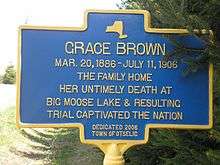 Historic marker of Grace Brown's family home, Otselic, NY |
Dedicated 2006 Town of Otselic | Stage Road by Brown Lane, Otselic, NY | Otselic, Town of, New York | N 42°39’29.5”
W 75°43’18.3” |
GRACE BROWN
Mar. 20, 1886-July 11, 1906 The family home her untimely death at Big Moose Lake & resulting trial captivated the nation | |
| Otselic, Town of, New York | GRACE BROWN | 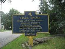 Historic marker of Grace Brown, Otselic, NY. The inspiration for Theodore Dreiser's "An American Tragedy". |
Dedicated 2006 Town of Otselic | NYS Route 26, Otselic, NY. Below the junction with Gorge Road, by the steps to the cemetery | Otselic, Town of, New York | N 42°38’44.8”
W 75°46’57.9” |
GRACE BROWN
Whose Life & Death Inspired Theodore Dreiser's "An American Tragedy" Her Final Resting Place in the Valley She loved | |
| Oxford, Village of, New York | SITE OF ANCIENT INDIAN FORT | 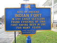 Historic marker of Indian Fort found in 1791, Oxford, NY |
State Education Department 1938 | NYS Route 220, in front of Oxford Middle School, Oxford, NY | Oxford, Village of, New York | N 42°26'26.2"
W 26.2"75°35" |
SITE OF ANCIENT INDIAN FORT
In 1791 early settlers found evidence of this fort having been in use for many years. | |
| Oxford, Village of, New York | CONGREGATIONAL CHURCH | 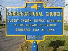 Historic marker of the Congregational Church in the village of Oxford, NY. |
State Education Department 1938 | Fort Hill Park, east side, Oxford, NY | Oxford, Village of, New York | N 42°26'25.8
W 75°35' 45.2 |
CONGREGATIONAL CHURCH
Oldest church edifice standing in the Village. Dedicated July 31, 1823 | |
| Oxford, Village of, New York | FIRST SITE OF OXFORD ACADEMY | 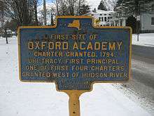 Historic marker of the first site of the Oxford Academy, Oxford, NY. |
State
Education Department 1938 |
NYS Route 220 on Washington Park, Oxford, NY | Oxford, Village of, New York | N 42°39’43.0”
W 75°19’55.8” |
FIRST SITE OF OXFORD ACADEMY
Charted granted 1794. Uri Tracy, first principal. One of the first four charters granted west of Hudson River. | |
| Oxford, Village of, New York | BALDWIN HOME | 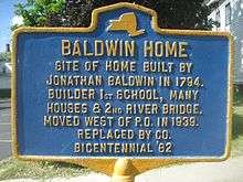 Historic marker of the Baldwin Home, Oxford, NY. |
Replaced by Co. Bicentennial “82 | West of Washington Ave. on West State Street, Oxford, NY | Oxford, Village of, New York | N 42°26’33.7”
W 75°35’56.5” |
BALDWIN HOME
Site of home built by Jonathan Baldwin in 1794. Builder 1st school, many houses & 2nd river bridge, moved west of P.O. in 1939. | |
| Oxford, Village of, New York | JUNCTION OF ITHACA-CATSKILL TURNPIKE | 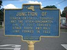 Historic marker of the Ithaca Catskill Turnpike, Oxford, NY. |
State Education Department 1938 | Washington Avenue and Lafayette Park, Oxford, NY | Oxford, Village of, New York | N 42°26’33.2”
W 75°35’53.5” |
JUNCTION OF
Ithaca-Catskill turnpike and the Utica-Binghamton line of Post Coaches. Stage route and mail line formed in 1822 | |
| Oxford, Village of, New York | OXFORD FIRST TOWN MEETING | 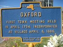 Historical marker of Oxford, NY, first town meeting, April 1794, village incorporated April 6, 1806. |
State Education Department 1938 | NY State Route 12 and Lafayette Park, Oxford, NY | Oxford, Village of, New York | N 42°26’32.2”
W 75°35’51.5” |
OXFORD
First town meeting held in April 1794. Incorporated as village . | |
| Oxford, Village of, New York | SITE OF LOG HOUSE | 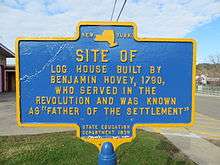 Historic marker at the site of Benjamin Hovey log house, Oxford, NY |
State Education Department 1938 | Park in front of Oxford High School, Oxford, NY | Oxford, Village of, New York | SITE OF LOG HOUSE
Built by Benjamin Hovey 1790, who served in the Revolution and was known as “Father of the Settlement” | ||
| Oxford, Village of, New York | SITE OF ST. PAUL'S EPISCOPAL CHURCH | 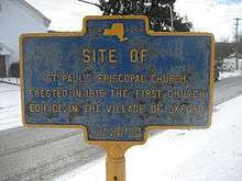 Historic marker of the site of St. Paul's Episcopal Church, first church edifice in village of Oxford, NY. |
State Education Department 1938 | Park in front of Oxford High School, Oxford, NY | Oxford, Village of, New York | SITE OF
St. Paul’s Episcopal church, erected in 1816. The first church edifice in the village of Oxford. . | ||
| Oxford, Town of, New York | LYON BROOK BRIDGE | 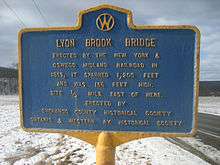 Historic marker of NY & Oswego Midland Railroad, Lyon Brook Bridge, Oxford, NY |
Chenango County Historical Society, Ontario & Western Railway Historical Society | Chenango County Highway 32 at Lyon Brook Road, between Norwich and Oxford, NY | Oxford, Town of, New York | N 42°27'44.7"
W 75°32'54.6" |
LYON BROOK BRIDGE
Erected by the New York & Oswego Midland Railroad in 1869, It spanned 1,200 feet & was 156 feet high. Site ½ mile east of here. | |
| Oxford, Town of, New York | LAKE WARN | 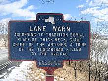 Historic maker of Lake Warn, Oxford, NY |
NYS ED Department 1938 | NYS Route 12 between Brisben and Oxford, NY | Oxford, Town of, New York | N 42°22'49.1
W 75°38'49.3" |
LAKE WARN
According to tradition burial place of Thick Neck, giant Chief of the Antones, a tribe of the Tuscaroras killed by the Oneidas. | |
| Pharsalia, Town of, New York | GAME REFUGE | 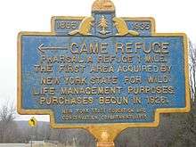 Historic marker of Game Refuge, Pharsalia, NY |
NYS Ed & Cons Dept
1955? |
NYS Route 23 at Benedict Hill Road, Pharsalia, NY | Pharsalia, Town of, New York | N 42°40'59"
W 75°31'1" |
1885-1935
GAME REFUGE Pharsalia Refuge 1 mile The first area acquired by New York State for wild life management purposes purchases begun in 1926. | |
| Plymouth, Town of, New York | DEPOT BUILT 1869 | 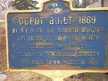 Historic marker of NY & OM Railroad, Auburn branch, operated by O & W Railroad. Restored in 1979 by the Plymouth Historical Society to use as Town Museum. |
Chenango County Route 16, east of Village of Plymouth, NY | Plymouth, Town of, New York | N 42°37’00.4”
W 75° 36’07.0” |
DEPOT BUILT 1869
by NY & OM RR Auburn Branch operated by O&W 1874-1879 Restored in 1979 by Plymouth Historical Society as a Town Museum | ||
| Preston, Town of, New York | SCHOOL HOUSE | 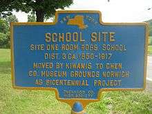 Historic marker on the site of one room schoolhouse, Ross School District 3, Preston, NY. 1850-1917. |
Chenango Co. Hist. Society | Chenango County Route 10, east of Village of Preston, NY | Preston, Town of, New York | N 42°32’26.2”
W 75°34’53.2” |
SCHOOL SITE
Site one room Ross School Dist 3 ca. 1850-1917 Moved by Kiwanis to Chen Co. Museum Grounds Norwich as Bicentennial Project | |
| Sherburne, Town of, New York | 1885 - 1935
GAME FARM |
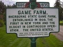 Historic marker of Game Farm in Sherburne, NY |
New York State Education and Conservation Departments, 1935 | NYS Route 80, west of Chenango County Route 23 and Cush Hill Road, Sherburne, NY | Sherburne, Town of, New York | N 42°40’58.0”
W 75°31’00.3” |
1885 - 1935
GAME FARM. Sherburne State Game Farm. Established in 1909. The first in and the oldest in continuous operation the | |
| Smyrna, Town of, New York | ALBANY-ITHACA TURNPIKE 100 | 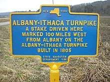 Historic marker of Albany Ithaca Turnpike, Smyrna, NY |
State Education Department 1936 | NYS Route 80, east of Chenango County Route.14, Smyrna, NY | Smyrna, Town of, New York | N 42°41’36.0”
W 75°33’21.2” |
ALBANY-ITHACA TURNPIKE
A stake driven here marked 100 miles west from Albany on the Albany-Ithaca Turnpike built in 1805 | |
| Sherburne, Town of, New York | FOOTBRIDGE | 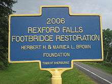 Historic marker of Rexford Falls, Sherburne, NY |
Town of Sherburne | NYS Route 80 at Rexford Falls, east of Sherburne, NY | Sherburne, Town of, New York | N 42°40’46.8”
W 75°28’15.9” |
2006
Rexford Falls Footbridge Restoration Herbert H. & Mariea L. Brown Foundation | |
| Sherburne, Town of, New York | WESTERN ORACLE | 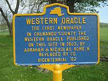 Historic marker of the Western Oracle, the first newspaper in Chenango County, NY. |
Replaced by Co. Bicentennial "82 | Chenango County Route. 20, east of railroad track, at Sherburne Four Corners, Sherburne, NY | Sherburne, Town of, New York | N 42°39’03.5”
W 75°34’44.3” |
WESTERN ORACLE
The first newspaper in Chenango County, the Western Oracle published on this site in 1803, by Abraham and Nicholas Romeyn. | |
| Sherburne, Town of, New York | WEST HILL
1802 |
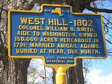 Historic marker of burial of Colonel William S. Smith, Sherburne, NY |
State Education Department 1936 | NYS Route 80, two miles northwest of Sherburne, NY, at entrance to West Hill Cemetery, Sherburne, NY | Sherburne, Town of, New York | N 42°41’38.5”
W 75°31’59.1” |
West Hill-1802
Colonel William S. Smith. Aide to Washington, owned 150,000 acres hereabout in 1791, married Abigail Adams. Buried at rear, due north. | |
| Smithville, Town of, New York | TARBELL FARMS | 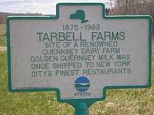 Historic marker of Tarbell Farms, Smithville, NY |
NYSDEC | NYS Route. 41 at Tarbell Road, Smithville, NY | Smithville, Town of, New York | N 42°25’00.9”
W 75°49’56.5” |
1875-1963
TARBELL FARMS Site of a Renowned Guernsey Dairy Farm Golden Guernsey milk was once shipped to New York Citys finest restaurants | |
| Smyrna, Town of, New York | BRIGHAM YOUNG | 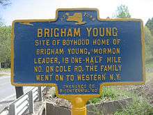 Historic marker of the boyhood home of Brigham Young. Cole Road, Smyrna, NY |
Chenango Co. Bicentennial ‘82
(Replaced after 1981) |
Chenango County Route 21, at Cole Road, Smyrna, NY | Smyrna, Town of, New York | N 42°39’03.5”
W 75°34’44.3” |
BRIGHAM YOUNG
Site of boyhood home of Brigham Young, Mormon leader, is one-half mile no. on Cole Rd. the family went on to Western N.Y. | |
| Oxford, Town of, New York | FORT HILL MILL | 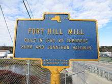 Historic marker of Fort Hill mill, Oxford, NY |
State Education Department 1938 | Chenango River bridge at the Oxford Fire Department, Main Street, Oxford, NY | Oxford, Town of, New York | N 42°26'28.6"
W 75°35'46.1" |
FORT HILL MILL
Built in 1794 by Theodore Burr and Jonathan Baldwin. | |
See also
References
- "New York State Historic Markers". New York State Historic Markers. New York State Museum. 2009-07-15. Archived from the original on 2013-03-24.