List of NYC Ferry stops
The following is a list of stops on NYC Ferry.
Stops
Stops on multiple routes
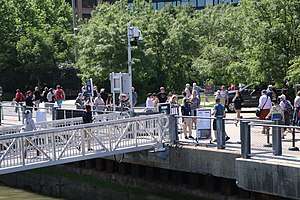
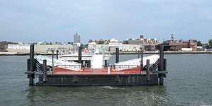
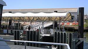
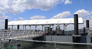
Pier 11/Wall Street
Pier 11/Wall Street is the terminal for all NYC Ferry routes, except for the St. George and South Brooklyn lines. The pier has five berths each with two ferry slips, and is also used by NY Waterway, New York Water Taxi, SeaStreak, and tour boats.
East 34th Street
East 34th Street Ferry Landing is served by the Astoria, East River, Soundview, and Lower East Side lines. The landing is also used by New York Water Taxi and SeaStreak as well as event ferries to Yankee Stadium, Randall's Island, and Citi Field.
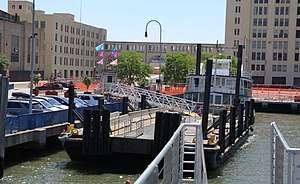
DUMBO
DUMBO (Brooklyn Bridge Pier 1) | ||||||||||||||||
|---|---|---|---|---|---|---|---|---|---|---|---|---|---|---|---|---|
| Ferry terminal | ||||||||||||||||
 | ||||||||||||||||
| Location | Old Fulton Street and Furman Street Dumbo, Brooklyn, New York, 11201 | |||||||||||||||
| Connections | ||||||||||||||||
| Services | ||||||||||||||||
| ||||||||||||||||
Located at the foot of Fulton Street, at the former Fulton Ferry landing, adjacent to Brooklyn Bridge Park's Pier 1. DUMBO is served by the East River and South Brooklyn routes.
Governors Island
Governors Island | |||||||||||
|---|---|---|---|---|---|---|---|---|---|---|---|
| Ferry terminal | |||||||||||
| Location | Gov. Island/Yankee Pier | ||||||||||
| Coordinates | 40.686854°N 74.017119°W | ||||||||||
| Services | |||||||||||
| |||||||||||
This stop is served by the Governors Island Ferry shuttle during summer weekends only. Prior to 2019, the East River and South Brooklyn ferries were extended from Wall St to Governors Island during summer weekends, before being replaced by the Governors Island shuttle in 2019.
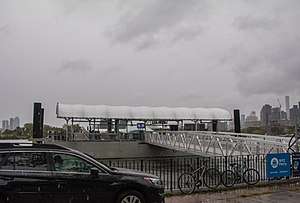
Sunset Park
Sunset Park | ||||||||||||||||
|---|---|---|---|---|---|---|---|---|---|---|---|---|---|---|---|---|
| Ferry terminal | ||||||||||||||||
 | ||||||||||||||||
| Location | 140 58th Street | |||||||||||||||
| Coordinates | 40.6455°N 74.02608°W | |||||||||||||||
| Services | ||||||||||||||||
| ||||||||||||||||
Located at the Brooklyn Army Terminal in Sunset Park, Brooklyn. Served by the South Brooklyn and Rockaway routes.
The landing was rebuilt and opened in 2018, with an all new waiting area.
Astoria route
Astoria
Astoria | |||||||||||
|---|---|---|---|---|---|---|---|---|---|---|---|
| Ferry terminal | |||||||||||
 | |||||||||||
| Location | 3-10 Astoria Boulevard, Astoria, Queens | ||||||||||
| Coordinates | 40.772114°N 73.937178°W | ||||||||||
| Connections | Q18, Q19, Q102, Q103 buses | ||||||||||
| Services | |||||||||||
| |||||||||||
The Astoria terminal is located in Hallets Cove between the Astoria Houses public housing project and Socrates Sculpture Park. Long Island City Community Boathouse runs an introductory kayaking program in the cove, and objected to the placement of the ferry terminal.[1]
Roosevelt Island
Roosevelt Island | |||||||||||
|---|---|---|---|---|---|---|---|---|---|---|---|
| Ferry terminal | |||||||||||
 | |||||||||||
| Coordinates | 40.772114°N 73.937178°W | ||||||||||
| Connections | |||||||||||
| Services | |||||||||||
| |||||||||||
Located underneath the Queensboro Bridge, NYC Ferry is one of three public transit options connecting Roosevelt Island with Manhattan, the other two being the F train and the Roosevelt Island Tramway.
Long Island City
Long Island City (Gantry Plaza State Park) | |||||||||||
|---|---|---|---|---|---|---|---|---|---|---|---|
| Ferry terminal | |||||||||||
 | |||||||||||
| Location | 46th Avenue and Center Boulevard Long Island City, New York | ||||||||||
| Connections | |||||||||||
| Services | |||||||||||
| |||||||||||
The Long Island City Ferry Terminal is located at the north end of Gantry Plaza State Park. It is served by the Astoria route in both directions.
Brooklyn Navy Yard
Brooklyn Navy Yard | |||||||||||
|---|---|---|---|---|---|---|---|---|---|---|---|
| Ferry terminal | |||||||||||
| Location | 63 Flushing Avenue Brooklyn, New York | ||||||||||
| Connections | |||||||||||
| Services | |||||||||||
| |||||||||||
The Brooklyn Navy Yard Ferry Terminal is located at Dock 72 in the Brooklyn Navy Yard, and opened on May 21st, 2019. It is served by the Astoria route in both directions.
Nearby, connections are available to the B67 bus within the Navy Yard, and the B57, B62, and B69 buses along Flushing Avenue.
East River Ferry
Hunters Point South
Hunters Point South | |||||||||||
|---|---|---|---|---|---|---|---|---|---|---|---|
| Ferry terminal | |||||||||||
 | |||||||||||
| Location | 54th Avenue on 2nd Street Long Island City, New York | ||||||||||
| Connections | |||||||||||
| Services | |||||||||||
| |||||||||||
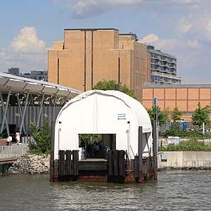
Greenpoint
Greenpoint | |||||||||||
|---|---|---|---|---|---|---|---|---|---|---|---|
| Ferry terminal | |||||||||||
 | |||||||||||
| Location | 10 India Street Greenpoint, Brooklyn | ||||||||||
| Connections | |||||||||||
| Services | |||||||||||
| |||||||||||
Located on the India Street Pier at 10 India Street in Greenpoint, Brooklyn along the East River. Served only by the East River route.
North Williamsburg
North Williamsburg | |||||||||||
|---|---|---|---|---|---|---|---|---|---|---|---|
| Ferry terminal | |||||||||||
 | |||||||||||
| Location | North 6th Street and Kent Avenue Williamsburg, NY 11249 | ||||||||||
| Connections | |||||||||||
| Services | |||||||||||
| |||||||||||
South Williamsburg
South Williamsburg | |||||||||||
|---|---|---|---|---|---|---|---|---|---|---|---|
| Ferry terminal | |||||||||||
 | |||||||||||
| Location | 440 Kent Avenue Williamsburg, NY 11249 | ||||||||||
| Connections | |||||||||||
| Services | |||||||||||
| |||||||||||
South Brooklyn
Corlears Hook
Corlears Hook | |||||||||||
|---|---|---|---|---|---|---|---|---|---|---|---|
| Ferry terminal | |||||||||||
| Coordinates | 40.71018°N 73.979238°W | ||||||||||
| Connections | |||||||||||
| Services | |||||||||||
| |||||||||||
Originally opened as part of the Lower East Side route in August 2018, it became the northern terminal of the South Brooklyn line on May 18, 2020.
Atlantic Avenue
Atlantic Avenue (Brooklyn Bridge Pier 6) | |||||||||||
|---|---|---|---|---|---|---|---|---|---|---|---|
| Ferry terminal | |||||||||||
 | |||||||||||
| Location | Brooklyn Bridge Park Greenway Brooklyn Heights, New York, 11201 | ||||||||||
| Connections | |||||||||||
| Services | |||||||||||
| |||||||||||
Red Hook
Red Hook (Atlantic Basin) | |||||||||||
|---|---|---|---|---|---|---|---|---|---|---|---|
| Ferry terminal | |||||||||||
 | |||||||||||
| Location | Ferris Street and Clinton Wharf Red Hook Brooklyn, New York, 11231 | ||||||||||
| Connections | |||||||||||
| Services | |||||||||||
| |||||||||||
The Red Hook Terminal is located in the Atlantic Basin next door to the Brooklyn Cruise Terminal.
Bay Ridge
Bay Ridge | ||||||||||||||||
|---|---|---|---|---|---|---|---|---|---|---|---|---|---|---|---|---|
| Ferry terminal | ||||||||||||||||
| Location | American Veterans Memorial Pier Bay Ridge Brooklyn, New York, 11220 | |||||||||||||||
| Connections | ||||||||||||||||
| Services | ||||||||||||||||
| ||||||||||||||||
Located on the north end of the 69th Street Pier in Bay Ridge, Brooklyn along the Verrazano Narrows, it opened as part of the original South Brooklyn line in 2018. Currently, it serves as the southern terminal of the South Brooklyn line, however, in 2021, South Brooklyn service will be discontinued at this stop and will instead be served by the new Coney Island route.
Rockaway route
Rockaway
Rockaway | |||||||||||
|---|---|---|---|---|---|---|---|---|---|---|---|
| Ferry terminal | |||||||||||
 | |||||||||||
| Location | Beach 108th Street and Beach Channel Drive Rockaway Park, New York | ||||||||||
| Connections | |||||||||||
| Services | |||||||||||
| |||||||||||
Located on the north side of Rockaway Park in Jamaica Bay. Served only by the Rockaway route, however the ferry terminal also has shuttle buses towards Edgemere to the east, and Jacob Riis Park to the west.
Soundview route
Soundview
Soundview | |||||||||||
|---|---|---|---|---|---|---|---|---|---|---|---|
| Ferry terminal | |||||||||||
| Location | Near Classon Point Park, The Bronx | ||||||||||
| Coordinates | 40.8049482, -73.8487173 | ||||||||||
| Connections | |||||||||||
| Services | |||||||||||
| |||||||||||
Located at the south east end of Classon Point park, it opened as part of the Soundview line on August 2018. It is currently the northern terminal of the Soundview Line. The Bx27 bus stops near the street loop on the north side of the street.
East 90th Street/Yorkville
East 90th Street (Yorkville) | |||||||||||
|---|---|---|---|---|---|---|---|---|---|---|---|
| Ferry terminal | |||||||||||
| Connections | |||||||||||
| Services | |||||||||||
| |||||||||||
Stuyvesant Cove
Stuyvesant Cove | |||||||||||
|---|---|---|---|---|---|---|---|---|---|---|---|
| Ferry terminal | |||||||||||
| Connections | |||||||||||
| Services | |||||||||||
| |||||||||||
Located at Stuyvesant Town on 23rd Street, it originally opened as part of the Lower East Side line in August 2018. When the Lower East Side line was discontinued, it was added as a stop to the Soundview line on May 18, 2020.
Coney Island route
Coney Island
Coney Island | |||||||||||
|---|---|---|---|---|---|---|---|---|---|---|---|
| Ferry terminal | |||||||||||
| Location | Near Coney Island, Brooklyn | ||||||||||
| Coordinates | N/A | ||||||||||
| Connections | |||||||||||
| Services | |||||||||||
| |||||||||||
This stop will serve as the southern terminal of the Coney Island line and will open in 2021.
St. George route
St. George
St. George | |||||||||||
|---|---|---|---|---|---|---|---|---|---|---|---|
| Ferry terminal | |||||||||||
| Location | Empire Outlets, Staten Island | ||||||||||
| Coordinates | 40.64515, -74.07470 | ||||||||||
| Connections | |||||||||||
| Services | |||||||||||
| |||||||||||
This stop will serve as the southern terminal of the St. George line and will open in 2021.
Coney Island route
Coney Island
Coney Island | |||||||||||
|---|---|---|---|---|---|---|---|---|---|---|---|
| Ferry terminal | |||||||||||
| Location | Near Coney Island, Brooklyn | ||||||||||
| Coordinates | N/A | ||||||||||
| Connections | |||||||||||
| Services | |||||||||||
| |||||||||||
This stop will serve as the southern terminal of the Coney Island line and will open in 2021.