Lihula Parish
Lihula Parish (Estonian: Lihula vald) was a rural municipality in Lääne County, Estonia. It had a population of 2,652 (as of 1 January 2010) and an area of 367.31 km2 (141.82 sq mi).[1] In 2017, Lihula Parish, Hanila Parish, Koonga Parish, and Varbla Parish were merged to form Lääneranna Parish.
Lihula Parish Lihula vald | |
|---|---|
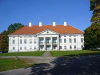
 Lihula manor | |
 Flag  Coat of arms | |
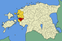
 Lihula Parish within Lääne County. | |
| Country | |
| County | |
| Administrative centre | Lihula |
| Area | |
| • Total | 367.31 km2 (141.82 sq mi) |
| Population (01.01.2010) | |
| • Total | 2,652 |
| • Density | 7.2/km2 (19/sq mi) |
| Website | www |
Settlements
Town
Villages
- Alaküla
- Aruküla
- Hälvati
- Järise
- Jõeääre
- Keemu
- Kelu
- Kirbla
- Kirikuküla
- Kloostri
- Kunila
- Laulepa
- Lautna
- Liustemäe
- Matsalu
- Meelva
- Metsküla
- Mõisimaa
- Nurme
- Pagasi
- Parivere
- Peanse
- Penijõe
- Petaaluse
- Poanse
- Rannu
- Rootsi
- Rumba
- Saastna
- Seira
- Seli
- Soovälja
- Tuhu
- Tuudi
- Uluste
- Vagivere
- Valuste
- Vanamõisa
- Võhma
- Võigaste
gollark: Error correcting codes at least.
gollark: I doubt it. There's presumably some intermediate encoding step going on.
gollark: If you have a video recorder program which does that, just take the output and mux out the video stream.
gollark: You can make Desmos draw π multiples on the axes?!
gollark: I can search through them easily enough.
References
- "Population figure and composition". http://www.stat.ee Statistics Estonia. Retrieved 11 August 2010. External link in
|publisher=(help)
This article is issued from Wikipedia. The text is licensed under Creative Commons - Attribution - Sharealike. Additional terms may apply for the media files.