Ligonier Historic District (Ligonier, Indiana)
Ligonier Historic District is a national historic district located at Ligonier, Noble County, Indiana. The district encompasses 253 contributing buildings and 2 contributing objects in Ligonier. It developed between about 1835 and 1937, and includes notable examples of Italianate, Queen Anne, Gothic Revival, Classical Revival, and Bungalow / American Craftsman style architecture. Located in the district are the separately listed Ahavas Shalom Reform Temple and Jacob Straus House. Other notable buildings include the Dr. Enos Fenton Residence (c. 1855), Silas Shobe Residence (c. 1870), Eli Gerber Residence (1874), Oscar Parks Residence (1892), Solomon Mier Residence (1906), Simon Schloss Residence (1912), Gentry Hotel (1870), Straus Brothers Block (1888), Zimmerman Block (1870, 1906), former Universalist Church (1856), Firs Presbyterian Church (1890), Ligonier Public Library (1908), Ligonier City Building (1914), U.S. Post Office (1935), Lyon and Greenleaf Flour Mill (1886), and former Mier Carriage Factory (1891).[2]
Ligonier Historic District | |
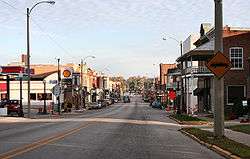
 Downtown Ligonier, October 2005 | |
  | |
| Location | Roughly bounded by Conrail right-of-way, Smith, Union, College, & Grand Sts., Ligonier, Indiana |
|---|---|
| Coordinates | 41°27′46″N 85°35′28″W |
| Area | 146 acres (59 ha) |
| Architect | Multiple |
| Architectural style | Late 19th And 20th Century Revivals, Late Victorian, Bungalow/craftsman |
| NRHP reference No. | 87001798[1] |
| Added to NRHP | October 23, 1987 |
It was listed on the National Register of Historic Places in 1987.[1]
References
- "National Register Information System". National Register of Historic Places. National Park Service. July 9, 2010.
- "Indiana State Historic Architectural and Archaeological Research Database (SHAARD)" (Searchable database). Department of Natural Resources, Division of Historic Preservation and Archaeology. Retrieved 2016-06-01. Note: This includes Craig Leonard (July 1986). "National Register of Historic Places Inventory Nomination Form: Ligonier Historic District" (PDF). Retrieved 2016-06-01., Site map, and Accompanying photographs.

