Lichtenstein (Osterode am Harz)
The Lichtenstein is a hill, 260.9 m above sea level (NHN)[1], in the southwestern Harz Foreland. It rises near Osterode am Harz in the Lower Saxon county of Göttingen.
| Lichtenstein | |
|---|---|
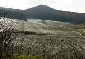 View of the Lichtenstein from the NE | |
| Highest point | |
| Elevation | 260.9 m above sea level (NHN) (856 ft) [1] |
| Listing | – Karstlandscape – Ruins of Lichtenstein Castle – Lichtenstein Cave |
| Coordinates | 51°43′16″N 10°10′33″E |
| Geography | |
 Lichtenstein | |
| Geology | |
| Type of rock | Lower Bunter sandstone, Gypsum karst |
There is a formation of Lower Bunter sandstone on the hill as well as the remains of Lichtenstein Castle. It is also the site of the Lichtenstein Cave.
Geography
Location
The Lichtenstein rises southwest of the Harz mountains between Förste to the north, Osterode am Harz to the east-northeast, Ührde to the southeast and Dorste to the south-southwest; it belongs entirely to the Osterode borough, the town itself being 5.3 (as the crow flies) east-northeast of the summit. The Söse tributary, the Salza, flows past the hill to the west. The hill's southwestern spur is the Badenhäuser Berg (221.6 m).
References
- Map services of the Federal Agency for Nature Conservation