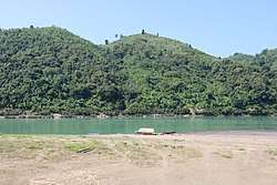
Lemro River
The Lemro (Burmese: လေးမြို့မြစ်, Burmese pronunciation: [lémjo̰ mjɪʔ]) is a river of Burma flowing through Chin State and Rakhine State. It flows into the Bay of Bengal east of Sittwe. The name of the river was given after establishment of four kingdom cities of Arakanese people between the eight and thirteen centuries along the river bank. The Lemro valley is noted for its rock art from these settlers.
| Lémro River လေးမြို့မြစ် | |
|---|---|
 | |
| Location | |
| Country | Myanmar |
| Cities | Mrauk U, Minbya, Pauktaw, Myebon, Sittwe |
| Physical characteristics | |
| Mouth | |
• location | Bay of Bengal |
• elevation | 0 m (0 ft) |
| Length | 183.5 km (114.0 mi) |
Etymology
In the term of "Lemro," the first term "Le" or "Lay" refers to counting number of "4" and the second term "Mro" refers to "town or city."
Physiography
Sources
Lémro river originates from the mountains and hills of Chin Hills Track in Chin State of Burma.
gollark: Huh.
gollark: Hmm. Obsidian can't be moved... iron maybe?
gollark: Getting to actually work on high-level details?
gollark: Radars, computer-driven TNT cannons, energy shields, lasers, fancy multiblock doors...
gollark: I would just use mods for this.
References
This article is issued from Wikipedia. The text is licensed under Creative Commons - Attribution - Sharealike. Additional terms may apply for the media files.