Leading Creek (Ohio)
Leading Creek is a tributary of the Ohio River, 29.5 miles (47.5 km) long,[3] in southeastern Ohio in the United States. Via the Ohio River, it is part of the watershed of the Mississippi River, draining an area of 150 square miles (390 km2)[3] on the unglaciated portion of the Allegheny Plateau. The creek's headwaters are in southern Athens County and it flows for most of its length in western Meigs County; its tributaries also drain a small area of northeastern Gallia County.[4]
| Leading Creek | |
|---|---|
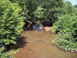 Leading Creek in Rutland Township in 2007 | |
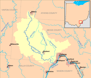 Map of Leading Creek and its watershed | |
| Location | |
| Country | United States |
| State | Ohio |
| Counties | Athens, Meigs |
| Physical characteristics | |
| Source | |
| • location | Lee Township, Athens County |
| • coordinates | 39.2359064°N 82.2190367°W[1] |
| • elevation | 820 ft (250 m)[2] |
| Mouth | Ohio River |
• location | Middleport |
• coordinates | 38.9845230°N 82.0715312°W[1] |
• elevation | 538 ft (164 m)[1] |
| Length | 29.5 mi (47.5 km) |
| Basin size | 150 sq mi (390 km2) |
| Basin features | |
| Tributaries | |
| • left | Little Leading Creek |
Leading Creek rises northwest of Albany in Lee Township in Athens County and initially flows southward into Meigs County, through Columbia Township, past the community of Carpenter; then southeastward through Salem, Rutland, and Salisbury townships, through the community of Langsville. It flows into the Ohio River at the south end of the village of Middleport.[4]
Little Leading Creek
Little Leading Creek is a tributary of Leading Creek and flows for its entire length in Meigs County. It rises at 39°08′54″N 82°09′16″W in Scipio Township and flows southward through the village of Rutland to 39°01′32″N 82°08′15″W in Rutland Township.[4][5] It is 10.6 miles (17.1 km) long and drains an area of 25.6 square miles (66 km2).[3]
See also
References
- Geographic Names Information System. "Geographic Names Information System entry for Leading Creek (Feature ID #1066794)". Retrieved 2011-10-12.
- Google Earth elevation for GNIS source coordinates. Retrieved on 2011-03-07.
- Ohio Department of Natural Resources (August 2001). "Gazetteer of Ohio Streams" (PDF). pp. 63–64. Retrieved 2011-10-12.
- Ohio Atlas & Gazetteer. Yarmouth, Me.: DeLorme. 1991. pp. 79–80, 87. ISBN 0-89933-233-1.
- Geographic Names Information System. "Geographic Names Information System entry for Little Leading Creek (Feature ID #1042671)". Retrieved 2011-10-12.