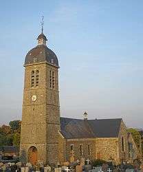
Le Tourneur
Le Tourneur is a former commune in the Calvados department in the Normandy region in northwestern France. On 1 January 2016, it was merged into the new commune of Souleuvre-en-Bocage.[2]
Le Tourneur | |
|---|---|
Part of Souleuvre-en-Bocage | |
 | |
Location of Le Tourneur 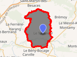
| |
 Le Tourneur  Le Tourneur | |
| Coordinates: 48°57′51″N 0°49′20″W | |
| Country | France |
| Region | Normandy |
| Department | Calvados |
| Arrondissement | Vire |
| Canton | Condé-sur-Noireau |
| Commune | Souleuvre-en-Bocage |
| Area 1 | 23.02 km2 (8.89 sq mi) |
| Population (2017)[1] | 638 |
| • Density | 28/km2 (72/sq mi) |
| Time zone | UTC+01:00 (CET) |
| • Summer (DST) | UTC+02:00 (CEST) |
| Postal code | 14350 |
| Elevation | 87–242 m (285–794 ft) |
| 1 French Land Register data, which excludes lakes, ponds, glaciers > 1 km2 (0.386 sq mi or 247 acres) and river estuaries. | |
Population
| Year | Pop. | ±% |
|---|---|---|
| 1962 | 738 | — |
| 1968 | 687 | −6.9% |
| 1975 | 593 | −13.7% |
| 1982 | 527 | −11.1% |
| 1990 | 506 | −4.0% |
| 1999 | 500 | −1.2% |
| 2008 | 577 | +15.4% |
gollark: Invent novel esolangs?
gollark: i.e. CraftOS, the CC OS thing, bootable on x86™.
gollark: Also, apparently someone made CraftOSOS?
gollark: I think they're all pretty cheap because mass production, so the only issues might be power consumption and complexity.
gollark: I see.
See also
References
- Téléchargement du fichier d'ensemble des populations légales en 2017, INSEE
- Arrêté préfectoral 1 December 2015 (in French)
| Wikimedia Commons has media related to Le Tourneur. |
| Authority control |
|
|---|
This article is issued from Wikipedia. The text is licensed under Creative Commons - Attribution - Sharealike. Additional terms may apply for the media files.