Le Rousset
Le Rousset is a former commune in the Saône-et-Loire department in the region of Bourgogne-Franche-Comté in eastern France. On 1 January 2016, it was merged into the new commune of Le Rousset-Marizy.[2]
Le Rousset | |
|---|---|
Part of Le Rousset-Marizy | |
 | |
Location of Le Rousset 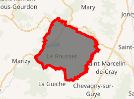
| |
 Le Rousset  Le Rousset | |
| Coordinates: 46°34′N 4°28′E | |
| Country | France |
| Region | Bourgogne-Franche-Comté |
| Department | Saône-et-Loire |
| Arrondissement | Charolles |
| Canton | Charolles |
| Commune | Le Rousset-Marizy |
| Area 1 | 24.74 km2 (9.55 sq mi) |
| Population (2017)[1] | 231 |
| • Density | 9.3/km2 (24/sq mi) |
| Time zone | UTC+01:00 (CET) |
| • Summer (DST) | UTC+02:00 (CEST) |
| Postal code | 71220 |
| Elevation | 265–486 m (869–1,594 ft) (avg. 433 m or 1,421 ft) |
| 1 French Land Register data, which excludes lakes, ponds, glaciers > 1 km2 (0.386 sq mi or 247 acres) and river estuaries. | |
Geography
The Arconce flows southwest through the western part of the commune and forms part of its southwestern border.
gollark: --tel dial MatsWidenBacon
gollark: bee.
gollark: ++magic py```python#timeout:50import asynciowhile True: await ctx.send("BEES") asyncio.sleep(1.05)```
gollark: ++magic py```pythonimport asynciowhile True: await ctx.send("BEES") asyncio.sleep(1.05)```
gollark: ...
References
| Wikimedia Commons has media related to Le Rousset. |
| Authority control |
|
|---|
This article is issued from Wikipedia. The text is licensed under Creative Commons - Attribution - Sharealike. Additional terms may apply for the media files.