Le Rouget
Le Rouget is a former commune in the département of Cantal in south-central France. On 1 January 2016, it was merged into the new commune Le Rouget-Pers.[2]
Le Rouget | |
|---|---|
Part of Le Rouget-Pers | |
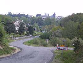 A general view of Le Rouget | |
Location of Le Rouget 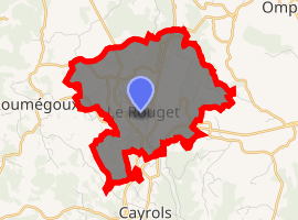
| |
 Le Rouget  Le Rouget | |
| Coordinates: 44°51′19″N 2°13′57″E | |
| Country | France |
| Region | Auvergne-Rhône-Alpes |
| Department | Cantal |
| Arrondissement | Aurillac |
| Canton | Saint-Mamet-la-Salvetat |
| Commune | Le Rouget-Pers |
| Area 1 | 8.23 km2 (3.18 sq mi) |
| Population (2017)[1] | 973 |
| • Density | 120/km2 (310/sq mi) |
| Time zone | UTC+01:00 (CET) |
| • Summer (DST) | UTC+02:00 (CEST) |
| Postal code | 15290 |
| Elevation | 555–665 m (1,821–2,182 ft) (avg. 600 m or 2,000 ft) |
| 1 French Land Register data, which excludes lakes, ponds, glaciers > 1 km2 (0.386 sq mi or 247 acres) and river estuaries. | |
Le Rouget, having grown from a hamlet as a result of coming of the railway, will not be found on many 19th-century maps. It was not granted commune status (and, with it, the right to elect a mayor of its own) until September 1945,[3] but is today a more important commercial and employment centre than the nearby historic cantonal centres of Saint-Mamet-la-Salvetat and Laroquebrou, although it lacks their architectural and historical interest.
A market is held every Sunday morning.
Population
| Year | Pop. | ±% |
|---|---|---|
| 1962 | 834 | — |
| 1968 | 918 | +10.1% |
| 1975 | 963 | +4.9% |
| 1982 | 902 | −6.3% |
| 1990 | 910 | +0.9% |
| 1999 | 901 | −1.0% |
| 2006 | 957 | +6.2% |
| 2012 | 962 | +0.5% |
gollark: Maybe *your* prime numbers.
gollark: Its factors are so boring.
gollark: How bland.
gollark: What's your favourite even prime number? Mine is 641240451.0 version 2.
gollark: Well, if you exclude GTech™'s collection.
See also
References
- Téléchargement du fichier d'ensemble des populations légales en 2017, INSEE
- Arrêté préfectoral 4 December 2015 (in French)
- Archive of Cantal about Saint-Mamet-la-Salvetat and the creation of Le Rouget.
| Wikimedia Commons has media related to Le Rouget. |
| Authority control |
|
|---|
This article is issued from Wikipedia. The text is licensed under Creative Commons - Attribution - Sharealike. Additional terms may apply for the media files.