Lao Khwan District
Lao Khwan (Thai: เลาขวัญ, pronounced [lāw kʰwǎn]) is a district (amphoe) in the northeastern part of Kanchanaburi Province, central Thailand.
Lao Khwan เลาขวัญ | |
|---|---|
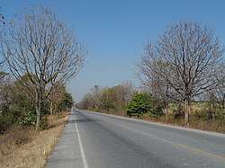 Road 3306, tambon Lao Khwan | |
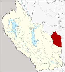 District location in Kanchanaburi Province | |
| Coordinates: 14°35′47″N 99°46′29″E | |
| Country | Thailand |
| Province | Kanchanaburi |
| Seat | Lao Khwan |
| Area | |
| • Total | 831.3 km2 (321.0 sq mi) |
| Population (2005) | |
| • Total | 54,967 |
| • Density | 66.1/km2 (171/sq mi) |
| Time zone | UTC+7 (ICT) |
| Postal code | 71210 |
| Geocode | 7110 |
History
Laotian people moved to establish a new village in the area of Ban Ko Ban Kao. Later people from Bo Phloi moved to the area. When the government established a new town, they named it Ban Lao Khwan.
The minor district (king amphoe) Lao Khwan was created on 1 October 1971, when the three tambons Lao Khwan, Nong Sano, and Nong Pradu were split off from Phanom Thuan District.[1] It was upgraded to a full district on 8 September 1976.[2]
Geography
Neighboring districts are (from the south clockwise) Huai Krachao, Bo Phloi, Nong Prue of Kanchanaburi Province, Dan Chang, Nong Ya Sai, Don Chedi and U Thong of Suphanburi Province.
Administration
The district is divided into seven sub-districts (tambons), which are further subdivided into 82 villages (mubans). Lao Khwan and Nong Fai are two townships (thesaban tambon), each covering parts of the same-named tambons. There are a further seven tambon administrative organizations (TAO).
| No. | Name | Thai name | Villages | Pop. | |
|---|---|---|---|---|---|
| 1. | Lao Khwan | เลาขวัญ | 15 | 9,333 | |
| 2. | Nong Sano | หนองโสน | 9 | 7,751 | |
| 3. | Nong Pradu | หนองประดู่ | 10 | 9,066 | |
| 4. | Nong Pling | หนองปลิง | 17 | 9,305 | |
| 5. | Nong Nok Kaeo | หนองนกแก้ว | 10 | 5,579 | |
| 6. | Thung Krabam | ทุ่งกระบ่ำ | 12 | 6,259 | |
| 7. | Nong Fai | หนองฝ้าย | 9 | 7,674 |
References
- ประกาศกระทรวงมหาดไทย เรื่อง แบ่งท้องที่อำเภอพนมทวน จังหวัดกาญจนบุรี ตั้งเป็นกิ่งอำเภอเลาขวัญ (PDF). Royal Gazette (in Thai). 88 (109 ง): 2802. October 12, 1971.
- พระราชกฤษฎีกาตั้งอำเภอเลาขวัญ อำเภอคำม่วง อำเภอพิปูน อำเภอศรีเทพ อำเภอนาแห้ว อำเภอส่องดาว อำเภอควนกาหลง อำเภอค่ายบางระจัน อำเภอบ้านตาขุน และอำเภอกุดจับ พ.ศ. ๒๕๑๙ (PDF). Royal Gazette (in Thai). 93 (109 ก special): 31–34. September 8, 1976.
External links
|  | |