La Chapelle-sur-Oudon
La Chapelle-sur-Oudon is a former commune in the Maine-et-Loire department of western France. On 15 December 2016, it was merged into the new commune Segré-en-Anjou Bleu.[2]
La Chapelle-sur-Oudon | |
|---|---|
Part of Segré-en-Anjou Bleu | |
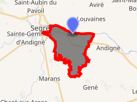
Location of La Chapelle-sur-Oudon 
| |
 La Chapelle-sur-Oudon  La Chapelle-sur-Oudon | |
| Coordinates: 47°40′46″N 0°49′31″W | |
| Country | France |
| Region | Pays de la Loire |
| Department | Maine-et-Loire |
| Arrondissement | Segré |
| Canton | Segré |
| Commune | Segré-en-Anjou Bleu |
| Area 1 | 12.73 km2 (4.92 sq mi) |
| Population (2017)[1] | 609 |
| • Density | 48/km2 (120/sq mi) |
| Demonym(s) | Chapellois, Chapelloise |
| Time zone | UTC+01:00 (CET) |
| • Summer (DST) | UTC+02:00 (CEST) |
| Postal code | 49500 |
| Elevation | 19–68 m (62–223 ft) (avg. 52 m or 171 ft) |
| 1 French Land Register data, which excludes lakes, ponds, glaciers > 1 km2 (0.386 sq mi or 247 acres) and river estuaries. | |
Geography
The river Oudon forms all of the commune's northern border.
gollark: Consider GPT-3, however.
gollark: And deconstructing it probably would have been better, yes, but for whatever reason I didn't.
gollark: It's osmarks, sorry.
gollark: I got banned on the July server by the automoderator after trying to use an artillery thing to get rid of a very annoying globally-playing music system. I'd like to be unbanned.
gollark: I see.
References
- Téléchargement du fichier d'ensemble des populations légales en 2017, INSEE
- Arrêté préfectoral 28 September 2016 (in French)
| Wikimedia Commons has media related to La Chapelle-sur-Oudon. |
This article is issued from Wikipedia. The text is licensed under Creative Commons - Attribution - Sharealike. Additional terms may apply for the media files.