Kyte, Norway
Kyte is a hamlet and basic statistical unit (grunnkrets) in the municipality of Voss in Hordaland county, Norway.[2]
Kyte | |
|---|---|
Hamlet | |
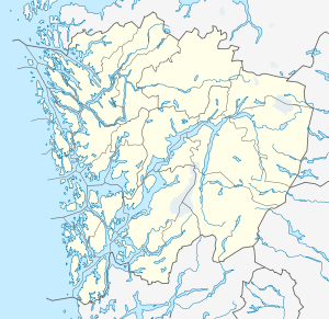 Kyte Location in Hordaland county  Kyte Kyte (Norway) | |
| Coordinates: 60°40′19″N 6°30′41″E | |
| Country | Norway |
| Region | Western Norway |
| County | Hordaland |
| District | Voss |
| Municipality | Voss |
| Elevation | 289 m (948 ft) |
| Time zone | UTC+01:00 (CET) |
| • Summer (DST) | UTC+02:00 (CEST) |
| Post Code | 5700 Voss |
Kyte includes Nedra Kyte[3] (literally, 'lower Kyte'; elevation 270 meters or 890 feet)[1] to the southwest and Øvre Kyte[4] (literally, 'upper Kyte'; elevation 307 meters or 1,007 feet)[1] to the northeast.[5][6] The settlement is accessible via Norwegian County Road 308, also known as Kytesvegen 'Kyte Road'.[7]
The settlement was attested as Kytuin in 1303 (and as Kytin in 1417 and Kythen in 1468, among other names).[5] The name is originally a compound of *Kýt-(v)in; the first element may mean 'hump, rise' and the second element, vin, is a common Old Norse place-name element meaning 'meadow, pasture'.[5]
References
- "Høydedata". Kartverket. Retrieved June 13, 2018.
- "Folkemengde grunnkretser - 12 Hordaland". Statistisk sentralbyrå. Retrieved June 13, 2018.
- "Nedra Kyte, Voss (Hordaland)" (in Norwegian). yr.no. Retrieved June 13, 2018.
- "Øvre Kyte, Voss (Hordaland)" (in Norwegian). yr.no. Retrieved June 13, 2018.
- Rygh, Oluf (1910). Norske Gaardnavne. Oplysninger samlade til brug ved Matrikelens Revision. 11. Søndre Bergenhus amt. Kristiania: Fabritius. p. 541. Retrieved June 13, 2018.
- Helland, Amund Theodor (1921). Norges land og folk: Søndre Bergenhus amt. Oslo: Aschehoug. p. 959.
- "Norgeskart". Retrieved June 13, 2018.
External links
This article is issued from Wikipedia. The text is licensed under Creative Commons - Attribution - Sharealike. Additional terms may apply for the media files.