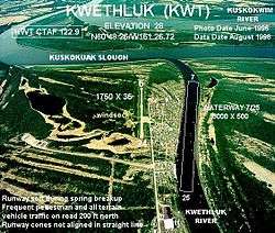
Kwethluk Airport
Kwethluk Airport (IATA: KWT[3], ICAO: PFKW[4], FAA LID: KWT) is a state-owned public-use airport located in Kwethluk, a city in the Bethel Census Area of the U.S. state of Alaska.[1]
Kwethluk Airport | |||||||||||
|---|---|---|---|---|---|---|---|---|---|---|---|
 | |||||||||||
| Summary | |||||||||||
| Airport type | Public | ||||||||||
| Owner | State of Alaska DOT&PF - Central Region | ||||||||||
| Serves | Kwethluk, Alaska | ||||||||||
| Elevation AMSL | 30 ft / 9 m | ||||||||||
| Coordinates | 60°47′25″N 161°26′37″W | ||||||||||
| Runways | |||||||||||
| |||||||||||
| Statistics | |||||||||||
| |||||||||||
As per Federal Aviation Administration records, this airport had 2,923 passenger boardings (enplanements) in calendar year 2007, an increase of 26% from the 2,329 enplanements in 2006.[2]
Facilities
Kwethluk Airport has one gravel surfaced runway (18/36) measuring 3,198 by 75 ft. (975 by 23 m).[1]
The airport was relocated from its former site at coordinates 60°48.26′N 161°26.72′W which had a 1,750 by 35 ft runway (6/24) and a 5,000 x 500 ft seaplane landing area.[5][6]
gollark: Got it working, just need to figure out these ¶egexes.
gollark: I have it *half* working, I just need to patch around this broken pytio library slightly.
gollark: Er, yes it does.
gollark: Working on converting <@509849474647064576> to support TIO instead of Coliru. It is not going well.
gollark: So just write no code?
References
- FAA Airport Master Record for KWT (Form 5010 PDF), effective 2008-09-25.
- Preliminary CY 2007 Passenger Boarding and All-Cargo Data. Federal Aviation Administration. 2008-07-17.
- KWT: Kwethluk Airport, Alaska. Aviation Safety Network. Retrieved 2008-09-21.
- PFKW: Kwethluk Airport, Alaska. AirNav.com. Retrieved 2008-09-21.
- Airport diagram (GIF). Federal Aviation Administration, Alaskan Region. 2004-04-15.
- Aerial photo showing locations of old and new airports. WikiMapia. Retrieved 2008-10-09.
External links
- Resources for this airport:
- Airport information for PKFW at AirNav
- Accident history for KWT at Aviation Safety Network
- Aeronautical chart and airport information for KWT at SkyVector
This article is issued from Wikipedia. The text is licensed under Creative Commons - Attribution - Sharealike. Additional terms may apply for the media files.