Kurima-jima
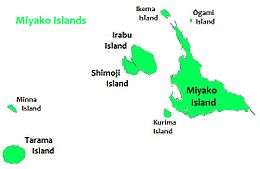
Kurima Island (来間島, Kurima-jima), (Miyako: Ffyama) is one of the Miyako Islands of Okinawa Prefecture, Japan. It is connected to Miyako-jima via 1,690m Kurima Bridge (来間大橋).[1][2]
| Native name: 来間島 | |
|---|---|
 Kurima-jima is located 1.5 km southwest of Miyako-jima | |
 Kurima Island | |
| Geography | |
| Location | Okinawa Prefecture |
| Coordinates | 24°43′20.47″N 125°14′49.10″E |
| Archipelago | Miyako Islands |
| Area | 2.84 km2 (1.10 sq mi)[1] |
| Administration | |
| Okinawa Prefecture | |
| Demographics | |
| Population | 161 (2015 national census)[1] |
Gallery
- Kurima-jima
 Bridge from Kurima-jima to Miyako-jima
 Beach on Kurima island
gollark: There is no 896 core CPU.
gollark: It might work with normal disk-as-cache functionality in OSes, but less efficiently than something dedicated probably.
gollark: I think they do work as normal NVMe disks based on interweb searching™, yes.
gollark: … what?
gollark: <@474726021652807680> There's some Linux thing to only allow certain connected devices to act as different device classes, you know. If BadUSB goes around emulating a keyboard or something that would stop it.
See also
References
- "Remote island related materials (離 島 関 係 資 料)" (PDF). Archived (PDF) from the original on 2020-02-15. Retrieved 2020-02-15.
- "Kurima-ohashi Bridge | Miyakojima | Japan Travel Guide - Japan Hoppers".
External links
| Wikimedia Commons has media related to Kurima Island. |
| Wikivoyage has a travel guide for Miyako Islands. |
This article is issued from Wikipedia. The text is licensed under Creative Commons - Attribution - Sharealike. Additional terms may apply for the media files.