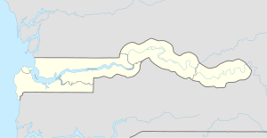
Kuntaur
Kuntaur is a town located in the Central River Division of the Gambia.[1]
Kuntaur | |
|---|---|
 Kuntaur Location in the Gambia | |
| Coordinates: 13°40′N 14°53′W | |
| Country | The Gambia |
| Division | Central River Division |
According to the 2013 census, there are 3074 inhabitants. The 1993 census gave an estimated population of 2286.
Geography
Kuntaur is located in Central River Division, in the district of Niani, on the north bank of the Gambia River which is about three kilometres south of Wassu and 13 kilometres north of Janjanbureh. The North Bank Road, an important highway crosses Wassu, where the well-known Wassu stone circles are located.
Cultural sights
The Senegambian stone circles which are regarded as a place of worship among the Serer are not far from the area.[2]
Economy and infrastructure
Located about 248 kilometres from the river mouth to the Atlantic Ocean, the town is the last inland port that can be navigated by large commercial ships. This port is a major transit point for peanuts and peanut related products.
References
- Johanson, Richard; Wilcox, Ryoko Tomita, (cont: Nathalie Lahire), Youth Employment and Skills Development in The Gambia, World Bank Publications (2011), p. 30, ISBN 9780821388112
- Meagher, Allen (pub), Historic sites of The Gambia. Ada Dinkiralu (Mandinka), Bereb-I-Chosan (Wolof), Tarica Tawal (Fula), Nannin (Jola), Soninke Ada (Serehuli), I-Mofan Chosan (Serer). An official guide to the monuments and sites of The Gambia. National Council for Arts and Culture, Banjul The Gambia (1998), p.15-16, OCLC 67789910