Kumealon Inlet
Kumealon Inlet is an inlet on the North Coast of British Columbia, Canada, on the eastern side of the north end of Grenville Channel facing Pitt Island.[1]
| Kumealon Inlet | |
|---|---|
 | |
 Kumealon Inlet | |
| Location | British Columbia |
| Coordinates | 53°51′39″N 129°59′33″W |
| Type | Fjord |
| Primary outflows | Grenville Channel |
Kumealon Inlet sits between the Ecstall Pluton and the Grenville Channel shear zone, and is bounded by rocks dating to the Albian (102.6±3.7Ma)[2].
Features
Connected features to the inlet are:
- Kumealon Island, located on the north side of the entrance to the inlet at 53°51′24″N 130°01′29″W [3]
- Kumealon Lagoon, a small arm on the north side of the inlet at 53°53′03″N 129°59′20″W,[4] connected to it via:
- Kumealon Narrows, a short narrows at 53°52′25″N 129°59′11″W [5]
- Kumealon Creek, a short creek which feeds northwest into Kumealon Lagoon, entering it at 53°52′41″N 129°58′02″W[6]
Images
| Wikimedia Commons has media related to Kumealon Inlet. |
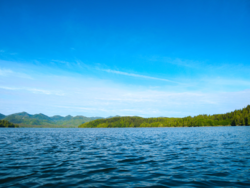
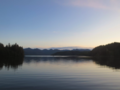 Looking Westward from the head of Kumealon Inlet towards the entrance
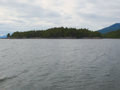 Kumealon Island
gollark: I forgot.
gollark: Oh no.
gollark: Please view the manual for more details.
gollark: That's actually nontrivial.
gollark: Who thought this was a useful thing to say?
See also
References
- BC Names/GeoBC entry "Kumealon Inlet"
- Wolfa D, Andronicosa C, Vervoortb J, Mansfieldc M, Chardon D (2010). "Application of Lu–Hf garnet dating to unravel the relationships betweendeformation, metamorphism and plutonism: An example from the PrinceRupert area, British Columbia" (PDF). Tectonophysics. 485 (2010): 62–77. Retrieved 2020-06-23.
- BC Names/GeoBC entry "Kumealon Island"
- BC Names/GeoBC entry "Kumealon Lagoon"
- BC Names/GeoBC entry "Kumealon Narrows"
- BC Names/GeoBC entry "Kumealon Creek"
This article is issued from Wikipedia. The text is licensed under Creative Commons - Attribution - Sharealike. Additional terms may apply for the media files.