Kudelin Point
Kudelin Point (Bulgarian: нос Куделин, ‘Nos Kudelin’ \'nos ku-de-'lin\) is the point on the northeast side of the entrance to Tlachene Cove on Loubet Coast, Antarctic Peninsula. The point is formed by an offshoot of Gaydari Peak, and was shaped as a result of the retreat of Hopkins Glacier during the last two decades of the 20th century.
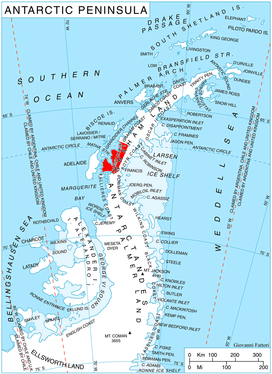
Location of Loubet Coast on the Antarctic Peninsula.
The feature is named after the settlement of Kudelin in Northwestern Bulgaria.
Location
Kudelin Point is located at 66°34′50″S 65°44′02″W, which is 27.4 km east of Madell Point, 18.3 km south of Phantom Point and 2.55 km northeast of Gostilya Point. British mapping in 1976.
Maps
- British Antarctic Territory. Scale 1:200000 topographic map. DOS 610 Series, Sheet W 66 64. Directorate of Overseas Surveys, Tolworth, UK, 1976.
- Antarctic Digital Database (ADD). Scale 1:250000 topographic map of Antarctica. Scientific Committee on Antarctic Research (SCAR). Since 1993, regularly upgraded and updated.
gollark: Sensors and propulsion are pretty useful, as we're meant to be surveying stuff and whatnot. Mining and power are important for infrastructure, I guess. Computing isn't too much of a problem as the magic computer box™ is only 10 minerals.
gollark: We don't really need weapons much, so that just leaves... everything else.
gollark: Anyway, can we get the research forks to focus on specific areas?
gollark: It's fine, we're probably overthinking this a lot...
gollark: I expect quantum stuff would probably just be special-purpose hardware running specific tasks while coordinated by classical computers.
References
- Kudelin Point. SCAR Composite Antarctic Gazetteer.
- Bulgarian Antarctic Gazetteer. Antarctic Place-names Commission. (details in Bulgarian, basic data in English)
External links
- Kudelin Point. Copernix satellite image
This article includes information from the Antarctic Place-names Commission of Bulgaria which is used with permission.
This article is issued from Wikipedia. The text is licensed under Creative Commons - Attribution - Sharealike. Additional terms may apply for the media files.